Adventures in the mountains…
21 minute read
April 6, 2024, 6:38 PM
From March 20-22, Elyse and I made our quarterly weekend trip down to Staunton. This was one where the planning was kind of light. We planned the dates and booked the room well in advance (vacation at my work is scheduled all at once for the year in June), but the planning for the actual adveture was a little light. So we just kind of played it by ear. It turned out to be pretty fun, with a few hard want-to-see things, and a lot of happy surprises in between. This trip started out somewhat unconventionally, though. Elyse got an early start in order to see the “Fleet of the Future” event that Metro was running down on the mall, so she left early and took the train down to see that (I went the following week, so stay tuned for my reportback there). I then left at my intended time, and scooped her from Vienna. Once I got Elyse, we were on our way again, heading down I-66 to I-81. The plan for the trip down was to stop in Middletown, where there was a place called Shaffer’s BBQ. We stopped in there for lunch on the September trip, and enjoyed it so much that we went again this time. Then our next stop was going to be Harrisonburg, because Elyse wanted to eat at D-Hall.
When we got off I-66 and onto I-81, though, we immediately noticed that the air was really smoky. We didn’t know what was going on, so we made our planned stop at Shaffer’s and did some research online. I ended up making a Reddit post while I was at Shaffer’s to see what I could find out. Reddit is pretty useful for that, throwing a question out there and then seeing what you get back. Consensus was that there were a bunch of wildfires burning in the state because of dry and windy weather, and that what we saw was most likely wildfire smoke. Okay.
Then after we finished at Shaffer’s, we continued on our trip south, taking US 11 to avoid an issue near exit 291 on I-81. While we were going down the road, Elyse spotted the source of the smoke: a large wildfire to our west. Okay, then. We pulled over and strategized a little bit, looking at Google Maps and figuring out how to tackle this. We ended up playing it by ear, taking various back roads while keeping an eye on our target and navigating closer to it. We pulled over at one point to get our bearings after going for a while without seeing the fire. There, we sent the drone up and verified where it was relative to our location.
Categories: Augusta County, Harrisonburg, JMU, Staunton, Staunton Mall, Travel, Virginia, Walmart
Making a weekend trip out of a delivery…
15 minute read
April 7, 2023, 10:00 AM
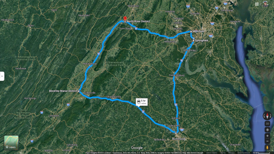
Recently, I was finally able to complete the last little bits of business related to the car accident from last October, and put it all behind me. On Thursday, March 30, I made the 175-mile journey to Stuarts Draft in the Scion – a trip that would leave it back home with my parents, where it belongs. And while I was at it, I made a weekend trip out of it, coupling it with a day in Richmond, where I did some photography. As such, I would traverse what I like to call Virginia’s “Interstate square”. If you look at a map of Virginia, the various Interstate highways in the state form something like a lopsided square, consisting of I-66 to the north, I-81 to the west, I-64 to the south, and I-95 to the east, and Strasburg, the DC area, Richmond, and Staunton at the corners:
Categories: Driving, Family, Harrisonburg, Howard Johnson's, JMU, Photography, Richmond, Roads, Scion xB, Staunton, Stuarts Draft, Travel
“Just singing a song…”
< 1 minute read
March 15, 2022, 12:00 PM
This past Thursday evening, Elyse and I found ourselves at JMU, touring the recently renovated Zane Showker Hall. I’m going to go into more detail on that adventure later, so stay tuned for that, but while we were in the lecture hall formerly known as G5 (now numbered 0212), I found a microphone up front, and it turned on and worked. When you give me a microphone, you never know what I’m going to do with it. In this instance, I had a little bit of fun with it, and belted out a tune, which Elyse recorded:
Categories: Harrisonburg, JMU, Today's Special
A flight over JMU…
4 minute read
May 15, 2021, 2:12 PM
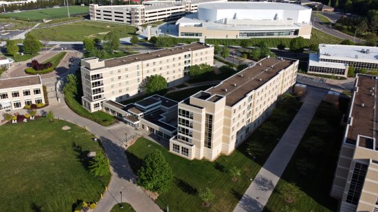
On May 10, while Elyse and I were on a weekend trip down to the Shenandoah Valley to see the parents and such, we stopped at JMU, and I took the drone for a flight over the far side of campus across Interstate 81. That is a part of campus that has definitely changed since I was a student, as it’s a lot more built up than it used to be. There are lots of buildings over there that weren’t there when I attended. There’s also a new indoor arena over there called the Atlantic Union Bank Center, or, as the folks on Reddit have taken to calling it, the “Algerdome”, after JMU’s current president, Jonathan Alger. I flew from a facility that was new since I was there, on the roof of a massive parking garage next to the Algerdome, built on the former site of Blue Ridge Hall. That higher vantage point was helpful because it gave me a better line of sight to my aircraft and a better signal for my remote, as there were fewer buildings getting in my way up there.
And here are the photos:
Categories: Harrisonburg, JMU, Photography
Flying over the Shenandoah Valley…
8 minute read
August 27, 2020, 11:25 PM
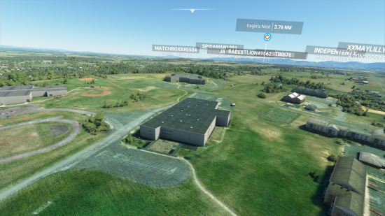
Recently, Elyse got a copy of the new Microsoft Flight Simulator game, which, among other things, features real landscapes based on map data. However, it’s not without its issues, since, if it doesn’t have good data for buildings and such, it attempts to fill in the gaps by rendering a building, taking a guess as to what kind of building it’s supposed to be. When there is good building data, the buildings look correct, as is the case in much of Howard County, Maryland. Down in Augusta County, that’s not the case, and most of the buildings are rendered by the game, doing its darndest to make a good guess. To accomplish this evening’s field trip, Elyse dropped us at Eagle’s Nest Airport, which is a privately-owned airport just outside Waynesboro. I didn’t have to fly the plane. Rather, we left the plane on the runway, and just flew around with the camera. I didn’t want to have to fly an airplane, after all. I just wanted to have a little eye in the sky. So from Eagle’s Nest, I quickly got my bearings, and made a beeline to Stuarts Draft.
First thing that I took a look at was my old middle school, Stuarts Draft Middle School:
Categories: Afton Mountain, Harrisonburg, Staunton, Stuarts Draft, Video games, Waynesboro
Finally, a road photo that I didn’t have to research…
2 minute read
July 11, 2015, 10:12 PM
Whenever I find a photo online showing something amusing on the road, I always like to find out the location. I’ve become rather skilled at looking at background details in photos to sleuth out locations after posting and geotagging countless photos on Panoramio, as well as researching filming locations for Project TXL (a planned overhaul of the Today’s Special site). So imagine my delight to see this funny road photo, showing Thomas the Tank Engine being transported on the back of a truck:
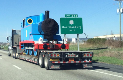
Photo: Imgur
Categories: Harrisonburg, Popular culture, Roads, Today's Special
Sometimes you have those weekends where you just have to get out of the house…
12 minute read
June 11, 2014, 6:06 PM
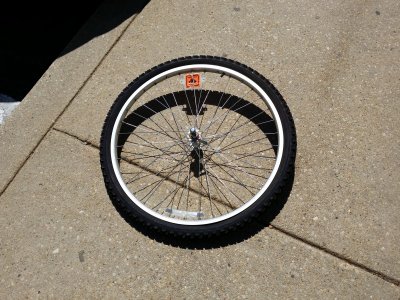
Ever get that feeling of “I just have to get out of the house”? I recently had that feeling, where I just needed a change of scenery for a little bit, and so I planned a weekend trip down to Stuarts Draft to visit the parents, going down Friday, and coming back Sunday. They were, as always, delighted to see me, and on the whole, we had a good time. I also made some extra space in my house, as, on Mom’s request, I brought my sister’s old bicycle back to my parents’ house. Gave me some practice in “beheading” a bicycle by removing the front wheel, and then reattaching it at my destination. But it travels much more easily without the front wheel:
Categories: Bicycle, Companies, Driving, Family, Fire drills, Harrisonburg, Middle school, Reddit, Stuarts Draft, Walmart, Waynesboro, Weather
A fun time was had by all…
9 minute read
April 7, 2010, 9:06 PM
So I got back from Stuarts Draft last night, and all in all, it was a pretty good trip. First of all, on the way down, I visited my friend Bergit, who I first met at the National Equality March back in October. We had a good time, chatting it up, and visiting a few stores in Charlottesville’s Corner district. Perhaps the most amusing part of the whole trip was the discovery that UVA sold a Snuggie with their logo on it, which Bergit modeled for the camera:
Categories: Charlottesville, Friends, Harrisonburg, JMU, Katie, Roads
The parking lot known as Interstate 66…
4 minute read
November 25, 2009, 10:07 PM
First of all, greetings from Stuarts Draft, where I’ve not been in six months. I’m here until Sunday, and left straight from work, which was interesting.
I tried something new this time around. I drove into work, worked a half day, and then left for Stuarts Draft straight from the office. For that, I took 16th Street from P Street to K Street, and then took K Street to I-66. Then I took 66 to the end, where I caught I-81 down to Staunton, and then from there, moseyed around a few back roads to Stuarts Draft and my parents’ house.
Driving into work and then leaving straight from work certainly has its ups and downs. On one hand, I can load up in the morning and then go, and not have to go back home to pick up the car, i.e. go north from the office back to Maryland just to immediately turn south again to go to Virginia. Then the drop-at-Vienna-the-night-before bit is a shade complicated. Recall that the drop-at-Vienna method involves positioning the car with most of the luggage in Virginia the night before, taking Metro and a bus back to Maryland, and then going to work like normal the next day. Then after work, take Metro to Vienna rather than Glenmont, grab the car, and zing off to Stuarts Draft. The idea there was to avoid the inside-the-beltway traffic by putting the car ahead of that and taking Metro to meet the car, but it’s just a bit too much trouble, and involves a lot of advance planning and coordination of what needs to be where. Plus it’s weird stashing the car and one’s luggage in another state for a night.
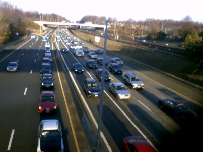
The whole idea is dealing with the traffic most effciently when there’s a workday involved. See, going into work precludes use of the Beltway for the trip out, since work is in Dupont Circle, near downtown Washington. One would think that it would have been less congested, but I-66 was slow all the way to Vienna. Seriously, I was on the phone with Mom part of the way, and was like, “I’m going eight miles per hour. Oh, wait, now ten. Wait… five.” Yeah, that slow. On the freeway. At least I had people on the phone, plus Randi Rhodes when I didn’t have anyone on the phone.
Categories: Driving, Harrisonburg, Stuarts Draft, Thanksgiving, Walmart
This was the first time we were all together in a long time…
4 minute read
March 17, 2008, 10:48 PM
Stuarts Draft was, as always, a lot of fun. And note, that is one sentence I never thought I’d find myself saying. But anyways…
So the whole dump-the-car-at-Vienna plan went according to plan, though it did take longer than I had planned to get out of the exit ramp. Of course, look what I had to contend with:
Categories: Driving, Family, Gas prices, Harrisonburg, Some people, Stuarts Draft
When I drive down to see the parents, I’m reminded of why I used to always do the driving on my DC trips in the early morning and late at night.
3 minute read
March 2, 2008, 11:30 PM
First of all, let me say that I had fun in Stuarts Draft and surrounding over the weekend. I came down Saturday morning, and went back up Sunday evening. In the process, I got to see Katie, my parents, and my friend Patrick Jarrett.
And the drive itself reminded me of why, when I did my bi-weekly DC trips for more than three years, I did the driving in the early morning and late at night. Traffic was much lighter than otherwise. On the way up to DC, I’d leave the house around 5:30 AM. Quiet on the highway. Then on the way back, I timed my arrival back at Vienna for around midnight to head back. Traffic was much lighter during those hours than otherwise. On my trip this time, where I took US 29 down, and I-81 and I-66 back, I think the only time when traffic wasn’t thick was on the way down between Culpeper and Ruckersville. Otherwise, it was pretty heavy traffic almost the entire way, including on US 340 going towards Stuarts Draft. Not fun.
However, the rest of the trip was fun. I got to see Katie for a few minutes, and then headed into Stuarts Draft to see the parents. They’ve made some changes to the “Pirate Room” (my old bedroom, which they’ve turned into an upstairs living room) since last I was there, removing my old desk and putting in this dresser with a ship painted on the front in the room in its place. It’s really nice, too. Meanwhile, we also finally named the pair of goldfish that Mom put in there. She hadn’t originally given them names because she couldn’t tell them apart, but I determined that one was more brightly colored than the other, thus we could tell them apart. I named them Castor and Pollux, after the twins in Greek mythology. It has a bit of a personal connection for me, as my astrological sign is Gemini, which is headed up by the stars Castor and Pollux. And in the fish, Castor is the more brightly-colored fish, while Pollux is the one with slightly more subdued colors.
Categories: Driving, Family, Harrisonburg, Stuarts Draft
I finally got a photo of the airport beacon…
< 1 minute read
December 25, 2007, 11:09 PM
While I was in Stuarts Draft and vicinity for Christmas, I finally got a photo of the airport beacon, which I previously discussed here and here. So here it is:
So there you have it. As you can see, it’s from a little private airport in Bridgewater. The only way one would know of its presence would be by seeing this beacon spinning around and around. But there you have it…
Categories: Harrisonburg
Bet you haven’t seen this before…
< 1 minute read
May 1, 2007, 6:06 PM
Categories: DC trips, Harrisonburg, WMATA
And what a wonderful time in Harrisonburg it was!
2 minute read
February 24, 2007, 9:25 PM
I had a fun day today in Harrisonburg. First of all, my time with Patrick went quite well. I got to meet his father, and the three of us had dinner at Ruby Tuesday. He also got to see the Sable, and he was impressed. It helped that I ran it through the car wash earlier that day, too. I also got to see his Chevy Venture, which was pretty neat.
The three of us were also in agreement that the people who designed the traffic patterns for the Harrisonburg Crossing shopping center deserve to be shot, since there are only three points of entrance to that very large and very congested shopping center. There’s one on Burgess Road, which leads to East Market Street (US 33). Then there are two at the other end on Reservoir Street. And the parking rows have no breaks from one end to the other. Therefore, you have two ways across the shopping center, parallel to the buildings. Right up against Wal-Mart and Home Depot, or right up against the Barnes and Noble/Michaels/Ross/Staples/Circuit City/whatever building. Thus it’s very easy to get stuck in parking lot hell, as you have to go all the way to either end to change rows, and the two side areas are VERY congested with traffic. Two words: It sucks. They would be very well served to reconfigure the parking lot to add another way across that massive lot parallel to the buildings. Imagine another path parallel to the buildings down the center. That would start directly in front of the main entrance at Reservoir Street to right in between O’Charley’s and Ruby Tuesday. The construction work necessary to do this would involve building some new parking lot islands to mark the new ends of the rows, and paving through some long islands that run perpendicular to the buildings and run the full length of the lot. Until they do that, which I don’t see as being likely to happen any time soon, have one hand on the horn, and have the middle finger on the other hand at the ready, because Harrisonburg drivers drive like idiots, and that goes for permanent residents and JMU students alike. Every time I have to cross that shopping center when it’s busy, another hair turns gray.
Categories: Friends, Harrisonburg
I found the beacon in Rockingham County
2 minute read
January 11, 2007, 2:43 PM
You may recall back in November in this entry that I was discussing a beacon visible from I-81 in Rockingham County.
Fast forward about a month and a half, and I can now tell you that I found the beacon. I was coming home from Harrisonburg last night, after attending a potluck at Rocktown Infoshop. I took Route 42 down as far as Bridgewater, and then crossed over to Route 11 on Dinkel Avenue. And there’s the light from the beacon, going around and around.
I’d spoken with some people about the beacon since I wrote my Journal entry, and they told me about an airport that I previously didn’t know about that exists in Bridgewater. I thought it was somewhat odd for an airport to be in Bridgewater, considering that the Shenandoah Valley Regional Airport exists just over the county line in Weyers Cave. But okay. There’s the light, and it had been a curiosity of mine for some years.
So I turned onto Route 11 and proceeded south through Mount Crawford, and turned right onto the aptly-named Airport Road. Airport Road starts out with a one-lane bridge over some river or stream, and then follows a series of sharp curves. All the while, the beacon’s light is still visible in the distance. And there are houses on this road. I could not imagine living so close to that beacon, but still, there you go. And as I traveled along this road, the beacon’s sweep became somewhat narrower, making it apparent that I was getting closer to the source.
Categories: Harrisonburg



 Continue reading…