


Adventures in the mountains…
21 minute read
April 6, 2024, 6:38 PM
From March 20-22, Elyse and I made our quarterly weekend trip down to Staunton. This was one where the planning was kind of light. We planned the dates and booked the room well in advance (vacation at my work is scheduled all at once for the year in June), but the planning for the actual adveture was a little light. So we just kind of played it by ear. It turned out to be pretty fun, with a few hard want-to-see things, and a lot of happy surprises in between. This trip started out somewhat unconventionally, though. Elyse got an early start in order to see the “Fleet of the Future” event that Metro was running down on the mall, so she left early and took the train down to see that (I went the following week, so stay tuned for my reportback there). I then left at my intended time, and scooped her from Vienna. Once I got Elyse, we were on our way again, heading down I-66 to I-81. The plan for the trip down was to stop in Middletown, where there was a place called Shaffer’s BBQ. We stopped in there for lunch on the September trip, and enjoyed it so much that we went again this time. Then our next stop was going to be Harrisonburg, because Elyse wanted to eat at D-Hall.
When we got off I-66 and onto I-81, though, we immediately noticed that the air was really smoky. We didn’t know what was going on, so we made our planned stop at Shaffer’s and did some research online. I ended up making a Reddit post while I was at Shaffer’s to see what I could find out. Reddit is pretty useful for that, throwing a question out there and then seeing what you get back. Consensus was that there were a bunch of wildfires burning in the state because of dry and windy weather, and that what we saw was most likely wildfire smoke. Okay.
Then after we finished at Shaffer’s, we continued on our trip south, taking US 11 to avoid an issue near exit 291 on I-81. While we were going down the road, Elyse spotted the source of the smoke: a large wildfire to our west. Okay, then. We pulled over and strategized a little bit, looking at Google Maps and figuring out how to tackle this. We ended up playing it by ear, taking various back roads while keeping an eye on our target and navigating closer to it. We pulled over at one point to get our bearings after going for a while without seeing the fire. There, we sent the drone up and verified where it was relative to our location.

Continuing on, we eventually found a spot where we found emergency responders blocking the road, which meant that we were very close by. We eventually found and followed Brooklee Ridge Lane, which was a private road with several houses on it, which was close enough to the fires that my drone could reach everything that I wanted it to see, while Elyse, the car, and myself were still a safe distance away. Like with the quarry fire the week before, the goal was to get the shots, but remain a safe distance away so as not to interfere with any firefighting efforts.


It made me sad to see the house on fire in that last photo, because you know full well that someone had just lost everything right then. We had heard some loud popping sounds while I was flying, and once we discovered the house on fire, we quickly put two and two together, realizing that the sounds happened when the fire reached some tanks alongside of the house, causing them to rupture. Northern Virginia Daily ran an article that included a photo of the house, at 1429 Coal Mine Road, just before the flames reached it. They ran another article discussing the aftermath of the fire, and show photos of it in its destroyed state. The family has set up a GoFundMe page following the fire. I donated, and you should, too.
While we were flying, a Loudoun County sheriff’s deputy came by to say hello to us. He was curious as to what we were up to because he lived in the last house on the road that we were on. When we explained that we were photographing the fire, he was appreciative, as we showed him the view from the drone’s camera, giving him an opportunity to see the fire from a higher angle than he otherwise could, and get a better feel for how much trouble he may or may not have been in as far as his own house was concerned.
Finishing up, we continued on our way. Our next stop was JMU, since Elyse wanted to eat at D-Hall. I didn’t join in for that, since I can’t eat like that anymore, and the price with tax comes to just under $18. That’s way more than I can justify, plus I wasn’t hungry, having had barbecue a couple of hours earlier (Elyse ate in DC, and didn’t have any barbecue). Plus it wasn’t my D-Hall anymore, as Gibbons Hall, the round building that I knew as D-Hall, had been demolished in 2016 and replaced with a new building that was not round.
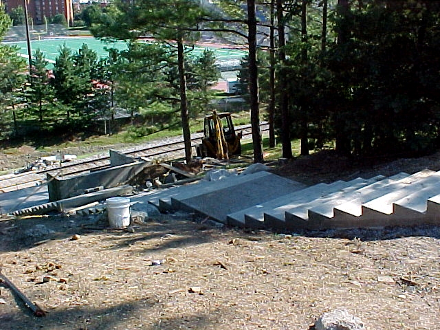
So while Elyse was there, I fired up the drone and photographed around campus a little bit. Due to daytime traffic restrictions, the closest that I could get to D-Hall was Godwin Hall, and so I dropped Elyse off at the “stairs of death”, a 68-step climb between Bridgeforth Stadium and D-Hall. That stair was made of wood for most of my time at JMU, and was replaced with concrete steps in the summer of 2002, which increased the stair count from 66 to 68. Here it is today:

Then I also buzzed around campus a bit, photographing a few things here and there.

Norfolk Southern railroad track through campus, facing approximately west. Note the students walking the track. Students have been doing that since forever. It’s unsafe, and not permitted, since it’s considered trespassing. Considering how long this has gone on, JMU should really work with Norfolk Southern to build a protected pedestrian path alongside the rail route, specifically to eliminate pedestrians on the track.

Norfolk Southern locomotive 4426 leads a train on its way through campus.

The Quad.

Keezell, Wilson, and Gabbin Halls, at the head of the Quad. D-Hall is located immediately behind Wilson.

Cupola on top of Wilson Hall.

Cupola on top of Gabbin Hall.

A new Village dorm, which replaces Ikenberry Hall. My understanding is that all of the old Village dorms will eventually be demolished and replaced with new buildings.

The Village, the Lake area, Godwin Hall, and UREC, viewed from above.

The other side of campus, viewed from above the Village.

King Hall, which I knew as the ISAT/CS building.

View past the Quad showing another wildfire in the distance. I noticed that it was a bit smoky in Harrisonburg as well, and I found the source of it. Wildfires were definitely a theme of our trip, as we spotted several on our first day, and went looking for some on the other days.
Having run out of sunlight for drone flying, I then went over to Gabbin Hall, which I knew as Maury Hall back then. There, I was more or less just killing some time photographing some stuff while Elyse finished up at D-Hall. I was surprised to find that the rooms where I had almost all of my political science and public administration classes were in the process of being renovated into computer labs for the assessment department. Here’s what one of the rooms looked like in March 2022:

Gabbin Hall room G1 in March 2022, more or less exactly as I remembered it.

Gabbin Hall room G1 in March 2024, cleaned out with no lights or ceiling.
I’m sure that the rooms will be really nice as assessment computer labs, and that it probably makes a lot of sense from an organizational standpoint, but I can’t help but feel a little bit sad that the rooms won’t be the way that I remembered them anymore. Time marches on, I suppose. Meanwhile, this amused me:

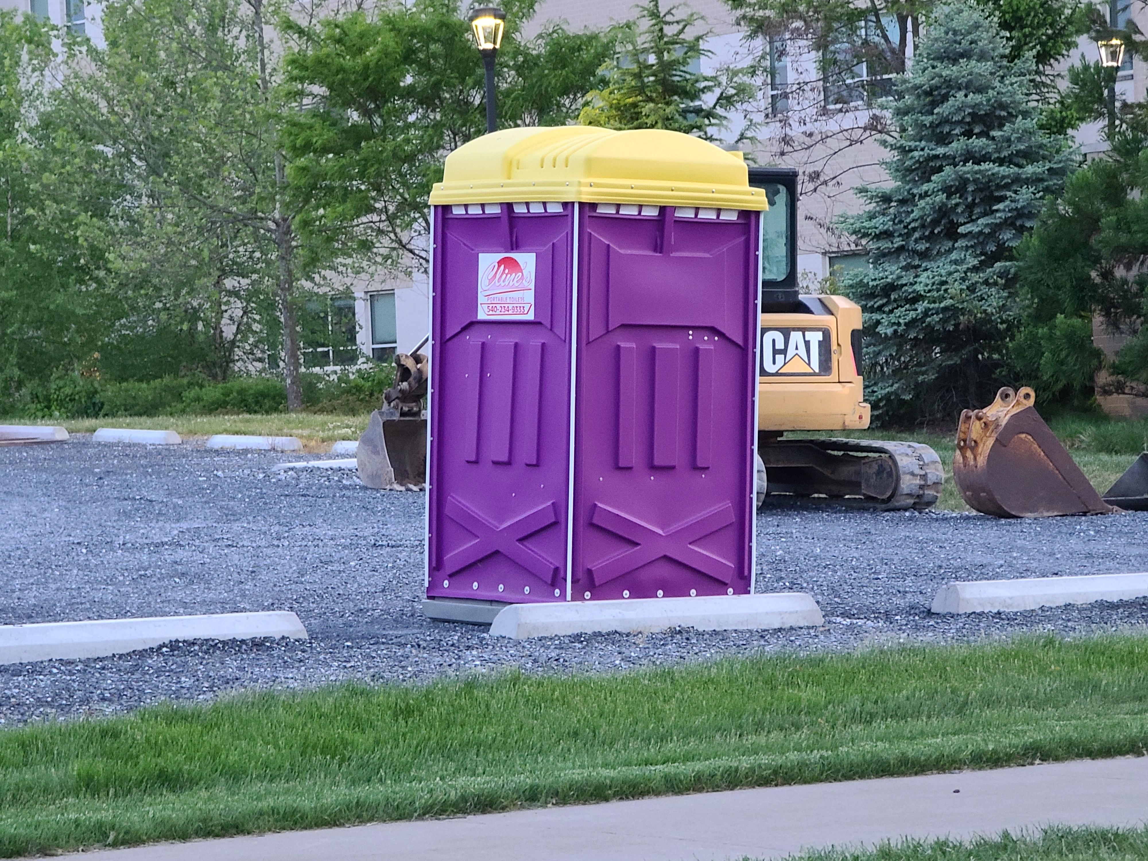
I couldn’t help but laugh about the fact that the doorstop is purple. Of course JMU would do that. I feel like this is a more recent thing, making everything purple, because they didn’t go this far into purple when I was a student (see the same room in 2002 with non-purple desks), and didn’t put it on every blasted thing like they do now. I mean, we get it. The school’s colors are purple and gold. But that doesn’t mean that everything, including the portapotties, needs to be purple. When everything has the purple theme like that, it comes off as more than a bit cheesy. I liked it when school colors were limited to just athletics, and didn’t take over every single aspect of the institution.
After that, we headed down to Staunton, got checked into the hotel, and all was well. I was going to go out and photograph a vintage neon sign in front of the Valley Mission in Staunton, but it was getting quite cold, so I pushed it off to the next night, which was a reasonable move.
The next day, we went on a road trip through the mountains of Virginia. Elyse wanted to see if we could spot any wildfires, and I looked forward to exploring further into this part of Virginia than we had explored before. The general track was to take 250 from Staunton to Monterey, and then turn south, and check out Warm Springs and Hot Springs along the way, revisit Gathright Dam and Lake Moomaw near Covington. If time allowed, we would also swing out to Lewisburg, West Virginia (though I considered that a long shot). Then we would swing east and return to Staunton via Lexington. Not a bad plan, if you ask me.
After breakfast, we started out on our adventure. Our first stop was the Sounding Knob Fire Tower near Monterey. This was not a new thing for either of us, as we had visited it once before in June 2022. Elyse wanted to look for wildfires, while I wanted to photograph from the top again.

Looking up at the Sounding Knob Fire Tower from the ground.

View of Monterey from the top of the fire tower.

Haze over the mountains as viewed from the top of the tower. When I was taking it, the thought crossed my mind that if I ever wanted to update the image of the sky at the top of the site with something newer, I could use this image. It might be worth exploring.
All in all, not a bad visit. I was surprised about how sturdy and well-constructed the fire tower was. I climbed up there in calm air, but once I was up in the little room at the top, it got really windy. The tower didn’t shake, sway, or make any kind of movement at all. My biggest complaint was that I didn’t bring my coat up with me, and so the climb up and down was quite cold. The room at the top of the tower was comfortable because it was fully enclosed.
Then we headed down the mountain into Monterey. Elyse wanted to visit the nearby Dollar General, while I found a place to sit and send the drone up into the air. I wanted to fly around Monterey, and considering how small of a town it is, it is possible to fly the whole thing from one location. I ended up parking behind the fire department, and got ready to go. However, before flying, I was distracted by the license plate on the fire truck that I parked beside:

I never realized that the “EMERGENCY VEHICLE” text on these plates was in Chicago, i.e. the classic Mac font. Interesting.
Then I got the drone prepped to go, and up it went.

The public school in Monterey, consisting of Highland Elementary School and Highland High School. Owing to the small population of Highland County (2,232 as of the 2020 census), this is the only public school in the entire county, and thus students attend this facility from kindergarten through 12th grade. I don’t know if I could have handled that, myself, spending 13 years in the same school. I definitely felt that I benefitted from changing schools as I leveled up, finding a new setting to grow into as I outgrew one level.

View of Monterey, facing approximately north. Monterey is a very small town, and this photograph captures most of it.

US 220 facing southbound, heading out of Monterey.

View of Monterey, facing approximately west.
 and Spruce Street.")
Intersection of West Main Street (US 250) and Spruce Street.

Cupola on the Highland County courthouse.

View of Monterey, facing approximately east.
Meanwhile, Elyse’s timing at the Dollar General was perfect. Seconds after I landed the drone, I saw Elyse come out of the store, and a phone call came shortly after that. I couldn’t help but think that if I was still up in the air, I could have done a follow-the-drone thing, making my drone’s presence known and asking Elyse to follow it, as the tune of The Sorcerer’s Apprentice started playing in my head. Instead, I just drove over and scooped.
After this, we went down to Jackson River Balery and Deli, an Amish-owned store just south of town. We’d been there once before, and they are quite good. I had the rest of my wrap from earlier, while Elyse got a sandwich, and we also shared an order of fries. Not a bad time.
We then continued on down the road, eventually getting to Warm Springs. We made a single stop in Warm Springs, at a gazebo that contained some information about Bath County, and I made a quick drone flight over the area. That was it for Warm Springs, as there really wasn’t that much else to see.

View from above the gazebo, facing northeast.

View from above the gazebo, facing southwest.

The Old Dairy Complex in Warm Springs.

The Warm Springs Pools, previously known as the Jefferson Pools, which comprise a spa facility.

And, of course, the gazebo.
After this brief flight, we continued a few miles down the road into Hot Springs. Compared to Warm Springs, Hot Springs was just hopping, as this was clearly the population center of the area (though it was still very much a small town). Our first stop in Hot Springs was at the Valley Supermarket IGA, which was the first full-line grocery store that we’d seen since we left Staunton that morning. Highland County, presumably owing to its very low population, has no full-line grocery stores. There is a Dollar General and a Dollar Tree/Family Dollar store in Monterey, and there are a number of small general stores that sell some grocery items, but that’s about it. Based on some research online, it seems that people who live in Highland County generally go to Staunton or Harrisonburg if they’re going into town to go shopping. I don’t know how they do it, because I can barely stand going over all of those winding mountain roads to get in and out of there. I couldn’t imagine doing that on a regular basis for routine needs, but I imagine that if I lived out there, I would figure it out.


Aisles at Valley Supermarket IGA, the only full-line grocery store for some distance.
Then we went to the main part of Hot Springs, where I flew around the Homestead Resort:


The weathervane on top of the cupola at the Homestead.
I imagine that the Homestead would be a fun place to visit, but we skipped it this time because Elyse wasn’t interested in visiting, which surprised me. But that’s how it goes sometimes.

The downtown area in Hot Springs. It’s a pretty small area, but it’s certainly quite vibrant.
Elyse and I then stopped in at the Duck In Deli & Market, which was a small restaurant and convenience store. They sold various convenience items, and then they also had fresh prepared sandwiches, and ice cream by the scoop. Elyse and I shared a cup of ice cream.
Then on the way out of Hot Springs on our way to our next destination, we spotted this:


This is a disguised cell phone tower (or as we call them, “cell trees”) located on some high ground behind the fire department in Hot Springs. Elyse spotted it, and so I took a few minutes to investigate it with the drone. We’ve seen cell trees before, but this one was unusual because it appeared to have all of the branches, but had almost no greenery on it. That lack of greenery made us wonder if it wasn’t supposed to look like a dead tree. Who knows.
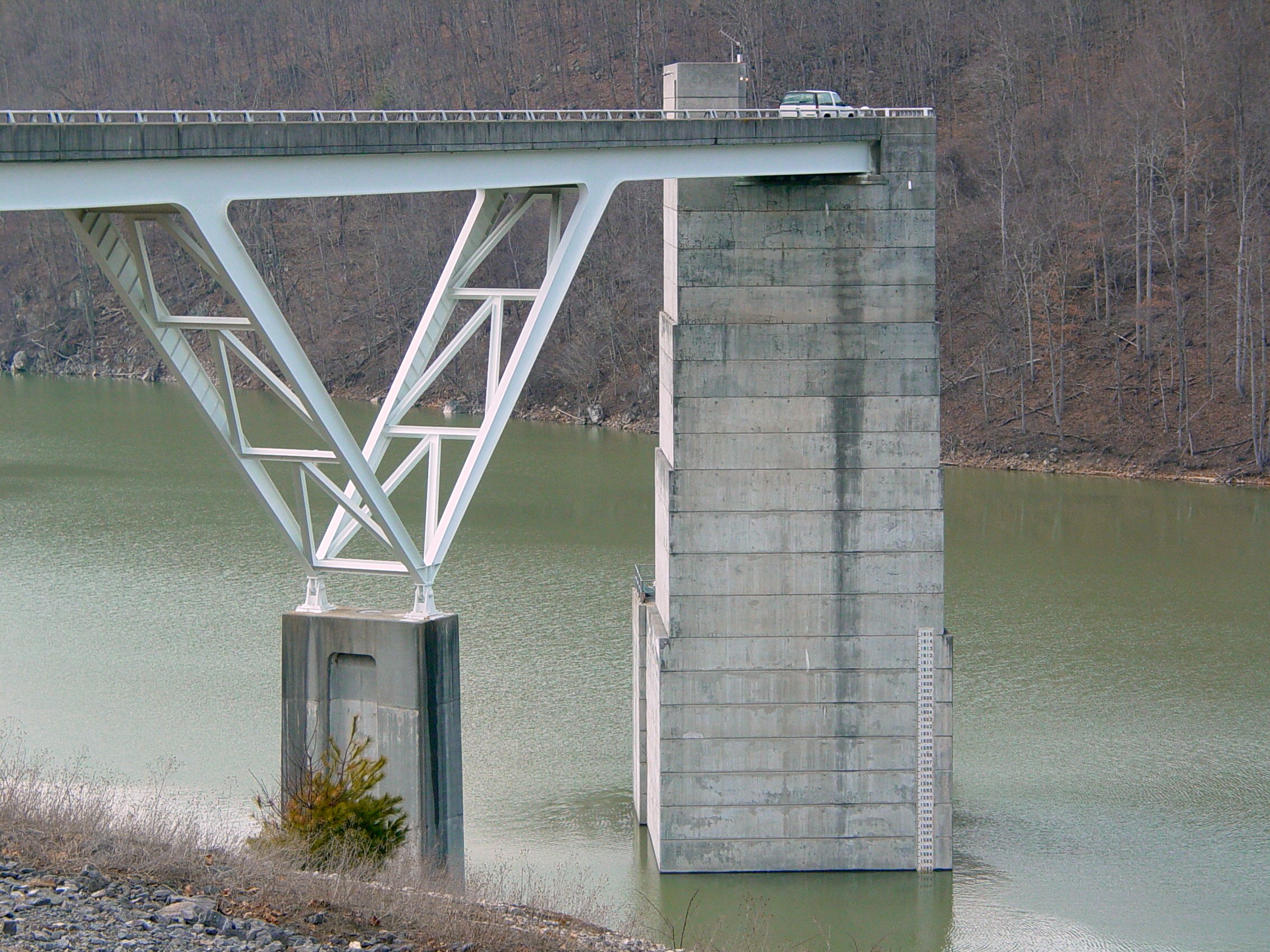
Then our next destination was Gathright Dam. This was something that I had last photographed about twenty years ago, and I wanted to update my shots, possibly with the drone. Getting to Gathright Dam was easy enough (just give Google Maps the location and go), but then when I got there, I spotted this:

Drat. Drones are prohibited on Corps of Engineers properties, which shot my plans for the dam, to get some new angles vs. my earlier shots. That meant that I was limited to more or less the same angles that I had available to me back in the 2000s. I was not pleased about that, but there you go, I suppose. One thing that I’ve noticed about the federal government is that they are pretty good about regulating drones to make sure that people operate them safely, but they absolutely hate when people fly them over their own installations, and often go out of their way to ban them over their own facilities. I also noticed that there were more security cameras then there were before, and there was a new siren on the dam, presumably to warn about large water discharges from the lake, but other than that, everything looked more or less the same as I remembered it.

“No parking” sign on the dam, same as in 2003.

This “NO TRESPASSING” sign on the steps going down the river side of the dam is new, replacing an older, slightly wordier sign.


The siren on top of the dam. This is a Sentry F-2-120 siren.

The river side of the dam, where the Jackson River resumes after the dam.

Bridge structure just upstream from the dam, unchanged from 2003.
Then we went over to the overlook trail.

Sign marking the location of the overlook trail. Recall in 2003 that I had intended to visit this overlook, but threw it out due to time constraints. The same thing happened this time around, as Elyse and I followed it for a short distance, but quickly realized that it was longer than we had anticipated, and we didn’t have enough time to complete it before the sun went down, so we aborted the mission again. However, that was a new sign compared to what was there in 2003.

Yellow blaze on a tree marking the overlook trail.
That was the end of the photography for the day, and we then headed into Covington. As expected, the window for Lewisburg had closed, but this was expected, as it was a bit out of the way at this point, and I wasn’t going to go into an unfamiliar small town at night to go sightseeing, because in the dark, what are you even going to see? We ended up going to the Walmart in Covington, where, to our surprise, a remodel was going on, taking the store from the late 2000s-era Project Impact store design to the current look:

Grocery side entrance with new bare concrete floor and old signage.

Remaining old tile on the old location of the electronics department.

Cordoning off the next area for floor work.

Moving a giant shelf gondola out of the way. It really looked like a big train moving through the store!

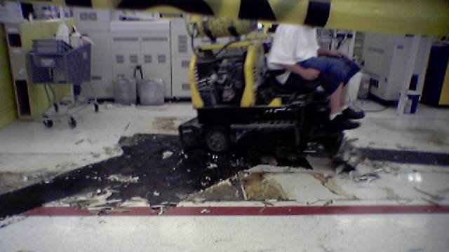
Using machinery to remove the wood-look tile floors in the clothing department. I got photos like this in 2005 when Lexington was being remodeled, but now, with a far superior camera, I was happy to get new shots.


The men’s restroom in the back of the store, freshly redone.
Leaving Walmart, we made a quick stop at the Love’s at the Low Moor exit, and then it was back to Staunton for us. When we got back to Staunton, we were greeted by a thick, smoky haze. Elyse quickly did the research, and it turned out that this was due to a wildfire in nearby Buffalo Gap. That said, that plan to photograph the Valley Mission sign just went right out of the window. The air quality was terrible, and I didn’t want to breathe that mess in, plus that smoke haze would affect my photos. So that went onto the list for another visit.
The next day, the first thing that we did was a Staunton Mall update. I dropped Elyse off at TJ Maxx, and then I took to the skies with the drone.

The former Staunton Mall, now with a lot less foundation, with more dirt visible than concrete.


Concrete debris around the former mall.

A large debris pile amongst a sea of floor tiles.

A pile of various wooden roots, presumably from the trees that used to grow inside the mall. From the air, though, I thought that it looked like steel wool.

A tire track through dirt that had not been exposed since the 1960s.

Heavy equipment at Staunton Mall, next to the Belk building.
Finishing up at the mall, I had some battery left, so I flew around the surrounding area.

Interchange between VA 262 and US 11. Route 262 is a loop road around Staunton, and is a full freeway, a Super 2, and a surface road at various points along its route.

Interchange between Route 262 and Old Greenville Road. Just after this exit, the road changes from a full freeway to a Super 2.

Communications tower on top of Mary Gray, the shorter of two mountains within the Staunton city limits.
From here, we caught 262 with the intention of taking it to VA 254 in order to go out to Buffalo Gap, as Elyse wanted to investigate the wildfire that was the source of all of the smoke that we saw in Staunton the night before. However, in going there, I made a mistake in navigation, and completely missed my exit, and only realized it once I saw signage for exits that were beyond where I intended to get off (whoops!). So I took what I considered a somewhat bold move, but one that I felt that I could complete on an undivided two-lane expressway. I pulled over, watched for a large gap in traffic (i.e. no vehicles at all), and then busted a big U-turn in the middle of that thing. I didn’t want any witnesses just in case the move that I was going to make was illegal, i.e. I didn’t want to get a ticket for it, but I completed the move safely, and we were on our way.
What we didn’t know yet, however, was that the fire that we were trying to investigate had been successfully put out overnight, so there was nothing to see. We set up at the corner of Hewitt Road and Parkersburg Pike, and I sent the drone up to investigate. Elyse had identified what she thought was smoke from the fire, but once I sent the drone up, it turned out that it was just a regular cloud. Going up without paying too much attention to the item of interest and then seeing nothing once I was at full altitude, I actually had to go back down almost to the ground in order to again identify my target and then ascend again. And I was able to verify: the item of interest was just a regular cloud, and no fire that I could find.
But I did get some decent shots while I was up there, and I admit that I picked that location in order to update my photos of Buffalo Gap High School, which I last flew over in 2021, and which has since been enlarged with the addition of a middle school wing.

Buffalo Gap High School, with its new middle school wing. Compare to a similar view taken in 2021.


The new middle school wing at Buffalo Gap. As I understand it, like at Riverheads, this new wing is essentially an entirely separate school from the high school, with only cafeteria food prep spaces’ being shared between the two. The new middle school wing otherwise contains all of its own services and amenities, including its own gymnasium (which means that this complex now has three gyms, as the high school had two gyms following a renovation in the 1990s).

The nearby mountain gap, i.e. Buffalo Gap itself, from which the area takes its name.
I admit that I have mixed feelings about Augusta County’s construction of middle school wings at Buffalo Gap and Riverheads. I feel like seven years is far too long to stay at one school, and in the same school environment. I feel that three or four years is the maximum that a child should remain in one school before advancing to the next tier, after which you kind of outgrow your setting and need to move on to continue your own growth. I also appreciated having a separate and distinct middle school experience, which was quite helpful for me. I hope that isn’t stifled by being directly attached to the high school, rather than being a totally separate structure in a different location. Additionally, considering that Augusta County has a tendency to underbuild as far as capacity goes (I can think of a few school construction projects that were overcrowded in their first year of operation), I hope that these are built to last, and won’t leave Augusta County scrambling for more space again in the near future.
We then headed into Waynesboro, where Elyse wanted to hit up a Dollar General in search of socks. We went to the downtown location, in what is clearly a former Rite Aid:

Funny thing. I remember when this site contained a store called “Little People’s Pharmacy”. That business was sold to Rite Aid, who briefly operated in the original building, before tearing it down and building this one. A similar thing happened in Stuarts Draft, where a second location of Little People’s Pharmacy was also acquired by Rite Aid, though in that instance, Rite Aid closed the location immediately, as a Rite Aid already existed in Stuarts Draft, to the left of Food Lion. A new Rite Aid store was built on the old Little People’s site there, and then Rite Aid moved to the new location. The old Rite Aid space was taken over by Food Lion to serve as an expansion, and the newer Rite Aid is now a Walgreens.
In Waynesboro, Rite Aid closed here some time between 2019 and 2022, and Dollar General opened in the building in 2023. The conversion is pretty elegant looking overall.
Things started winding up from there. Finishing up at Dollar General, we went to see my parents, and then we all had dinner over at Edelweiss German Restaurant in Greenville. Mom also recently discovered my YouTube channel, and so we watched some of those, particularly my (in)famous chili-making video. It’s funny in a stupid kind of way, but it amuses all the same. Then we dipped into my ex-store, i.e. Walmart #5117 in Waynesboro, and then we headed home via US 29. We made a pit stop at the Cook Out in Manassas on the way up, where, if I were to change one thing about that location, I would add a drop ceiling in order to help dampen the echoes.
And that was our trip! Not a bad time, if you ask me.
Categories: Augusta County, Harrisonburg, JMU, Staunton, Staunton Mall, Travel, Virginia, Walmart