


A proper visit to Charleston…
28 minute read
May 9, 2024, 10:14 AM
From April 17-19, Elyse and I made a weekend trip down to Charleston, South Carolina. It’s funny how this worked out. After our visit to Charleston last October, we both were left wanting more. We saw lots of potential in Charleston, and wanted to go back, but we weren’t sure whether we wanted to drive back again, vs. flying. Charleston is eight hours away, which is quite a long haul, and it’s almost entirely through rural areas once you get out of the DC region. In other words, not very exciting. But then when we looked at airfare, we realized that it was really expensive, and that with all of the goings-on at the airport plus multiple flights, we wouldn’t save any time compared to driving, plus we would be limited as to what we could bring with us, and would probably need to rent a car down there. All of that said, that pushed me into driving territory, because then we could bring whatever we wanted, go on our own schedule, and have fun on the way down and back. Plus then we would have the HR-V in Charleston.
On the southbound leg, I tried to keep the trip as close to all-business as I could. I only planned on making four stops: one in the Richmond area, one in Skippers, Virginia (the last Virginia exit on I-95), one somewhere in North Carolina, and then one at the Buc-ee’s in Florence, South Carolina. That would get us to Charleston at a somewhat reasonable hour as long as we kept to it.
Richmond was intended primarily as a food stop. My original idea was to stop at the Sheetz at the Atlee exit, and do Sheetz, and I pitched that to Elyse a few days prior to our trip. It’s funny – when I pitched the idea, Elyse’s response was something to the effect of, “When were you going to tell me about this?” and my response was simply, “What does this look like?” Elyse said that she didn’t want to do Sheetz, because we always do Sheetz, and then suggested we find a barbecue place. I was like, “You had me at barbecue.” Looking it up, I found two places that weren’t too far off of I-95. One was a place called Q Barbeque up in Glen Allen, and then the other one was Oak & Apple right in downtown. I chose Oak & Apple, because it was right in downtown Richmond, and closer to the freeway. More or less get off of the exit, go like two blocks, and boom, there it is.
And here’s the result:


My lunch. This was their BBQ Banh Mi, which consisted of pulled pork, hoisin BBQ, pickles carrots, cilantro, jalapeños, and pork cracklins, and a side of apple slaw. I enjoyed it.

Elyse’s beer, a Dark Hollow Bourbon Stout.

Washing up afterwards, I just loved this little sink in the men’s restroom. It was mounted in the corner, and was very tiny.
We both enjoyed the place thoroughly. We sat at the (outdoor) bar, and got friendly, quick service.
Finishing up there, we were back on our way, continuing down I-95. We were reminded of the infamous speed trap on I-95 as it goes through Emporia when we spotted an Emporia city cop sitting in the median of 95 with his radar out, ready to raise some money. I consider patrolling an Interstate like this, trolling for drivers to ticket, to be somewhat out of bounds for local police to do. After all, we have state troopers for this, and if city cops are out raising money on the freeway like this, that means that they’re not doing things that might directly benefit the city. Additionally, there’s the other side of things: if the city is that hard up for money, they should do the honest thing and just raise taxes. If the city’s leaders don’t have the balls to do that, then what’s the point of their being there?
The stop in Skippers was pretty straightforward: stop in at the truck stop, fuel the car, hit the restroom, look around briefly, and then hit the road again. We stayed on the road for another two hours and 130 miles. Where we were going to stop while we were in North Carolina was subject to some amount of discussion, since it was something of a balancing act. I wanted to put it as close to the middle of North Carolina as I could, since Skippers was at the end of Virginia, and Buc-ee’s was very close to the northern border of South Carolina. We ended up making the stop in Fayetteville, because Elyse wanted to see the transit center.
As it turned out, Fayetteville was not that interesting. All of the transit buses were off the road by 7 PM, and the transit hub also closed by then, which meant no restroom usage for us there. It was also the first time that I heard the recurring theme of this trip, which was “Transit is an afterthought”, sung to the tune of “Camptown Races“.
About the only thing interesting about the town was that Interstate 95 had a business loop through Fayetteville, co-signed with 301:

Interstate 95 business loop, co-signed with US 301. Considering that 301 is also signed through the whole thing, this seems pretty redundant.
All in all, I suspect that we’re not going to spend much time in Fayetteville again. The town seemed sketchy as hell with what felt like an out-sized police presence, and didn’t have much of interest in it.

I believe that David’s expression says it all. He was completely unimpressed by Fayetteville.
Next stop was the Buc-ee’s in Florence. We were both looking forward to Buc-ee’s.

Buc-ee’s in Florence, South Carolina. It was good to be back.

Meanwhile, I dressed the part. I specifically wore the Buc-ee’s tights that I bought there the last time I was through, knowing that we would visit again. I also love these tights compared to others because they have pockets.

Buc-ee’s private label animal crackers. We didn’t get these, but they were kind of cool looking.
And as usual, Buc-ee’s got us for about $200 dollars worth of food and other stuff. We got a big Buc-ee’s branded towel, we got shirts, and we got a whole bunch of food stuff to take home, like Beaver Nuggets, jellies and jams, salsa. We also got brisket sandwiches to eat in the car. I certainly wish that Buc-ee’s provided areas to eat, but I completely understand why they don’t do that, because they would be completely mobbed all the time, plus having to deal with cleaning all of that area up.
Then from Buc-ee’s, we did the remaining two hours and change to Charleston. This was not unfamiliar territory, as this was the same route that we took the last time we went. The notable thing here was I-95 between Florence and I-26, where the pavement causes an exceptionally loud sound when you’re driving over it. I don’t know what exactly causes loud pavement, but whatever it is, this road had it.
When we arrived in the Charleston area, we first stopped in at General Diesel. Had to check in on our friend:

There she is, the bus that we came down for last time and were not able to bring back home. The estimates have come back in, and while everything wrong with it can be fixed, it’s going to cost a big chunk of change to do. Whether that happens, however, is not up to me. But we at least wanted to say hello.
Then we headed down to our hotel. We were staying at the same Hampton Inn that we stayed at on the previous trip. We had looked around a bit online to see if there were other properties that might be a better price and/or a better location, but where we stayed last time turned out to be the best overall value as far as location and price went. We were, however, surprised to find out that the hotel was in the end stages of a remodel while we were staying there. As such, the front desk was cordoned off, as it was getting its updates, and so the interim “front desk” was the office behind the regular front desk. It was certainly interesting to see the inner workings of the front desk, that’s for sure. The majority of the hotel, including all of the guest rooms, was already completed, with only the major public spaces’ still either awaiting remodeling or actively undergoing remodeling.
The next day, the first thing that Elyse and I did was the Citadel Mall, which was a hop and a skip away from our hotel. That mall was pretty typical of a lot of shopping malls as of late, being past its prime with a lot of stores in spaces that were clearly built for someone else, and two nontraditional anchor tenants (a medical facility, and what appeared to be a church).
I started out with the drone, getting some aerial views.


Then I photographed the church with my DSLR:

The “church” turned out to be a filming location for The Righteous Gemstones, and apparently houses a production company inside.

I was, however, amused at how little effort they made to hide the name of the previous tenant. Clearly, the Sears letters were removed when Sears vacated, and the new tenant just put their sign up over it without even so much as painting out the labelscar.
Then I went in, and got a few photos of a few clearly converted stores:

Master Fix, in a former Zales Jewelers.

Collectors Corner in a former American Eagle Outfitters.

Condon’s Bridal & Gifts in a former Victoria’s Secret.
Then a couple of other shots:

Former Great American Cookie location.

Neon food court sign. The food court, along with the Target, was also the only part of the mall that really looked full and busy. I imagine that the medical facility’s proximity to the food court has an effect on that.
Then we headed downtown. I dropped Elyse off at the transit hub downtown in order to fan CARTA, and then I was unsupervised for a while. I ended up stopping in front of a former furniture store downtown and got a photo of the signage:
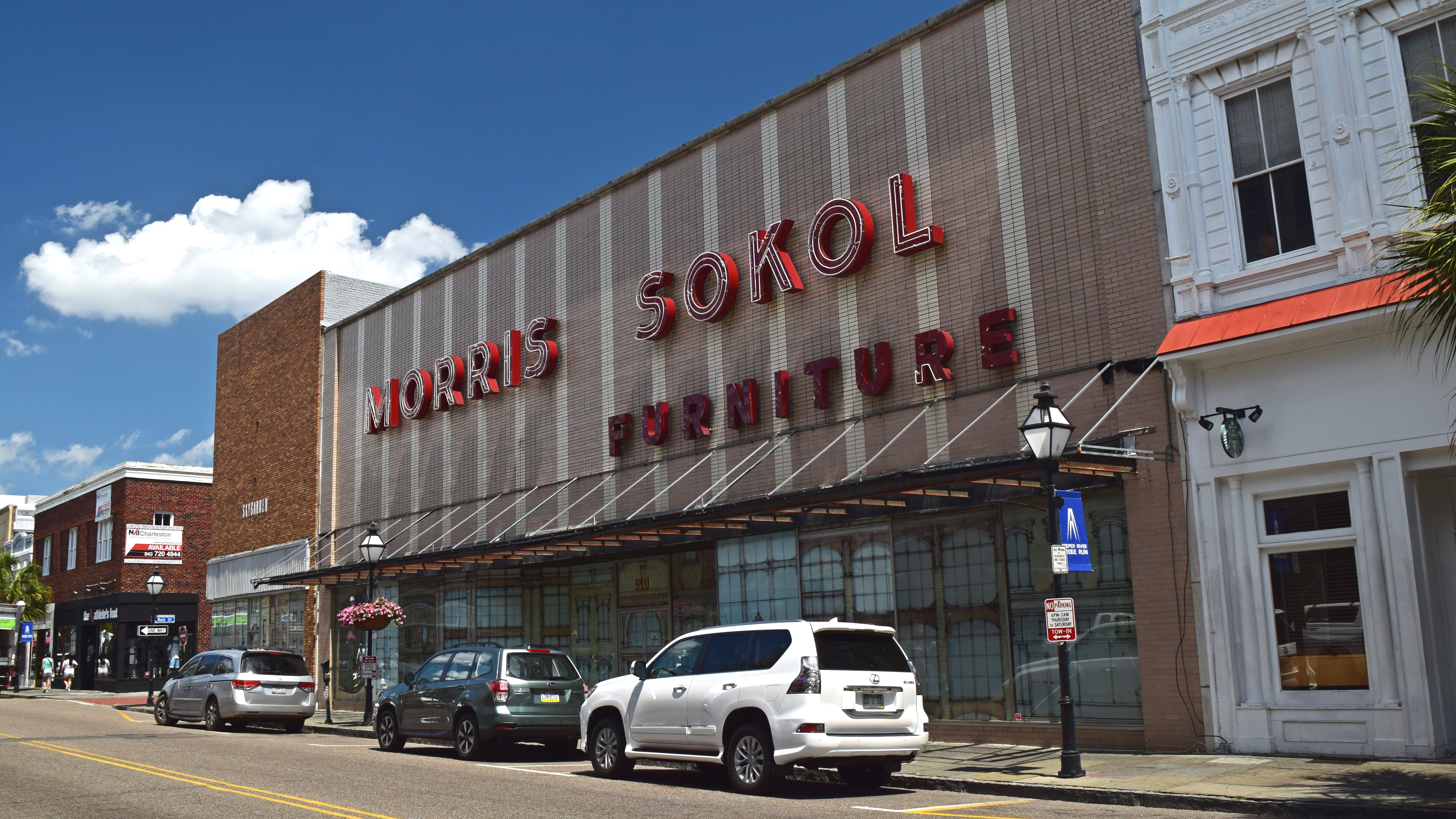
The Morris Sokol Furniture building. Apparently, this site housed its namesake furniture store from 1921 to 2015, and has been the subject of various proposals for reuse in the years since.
I also photographed a palmetto:

I really wanted to get a clear shot of a palmetto tree while on this trip, but this was the best that I was able to pull off, mainly for lack of freestanding palmettos in places that I could get to. Most of them were adjacent to buildings or in a cluster with other palmettos. I got the sense that while palmettos are indeed native to South Carolina, they were really only used decoratively in Charleston.
Then I went out of downtown to photograph a round Holiday Inn building and some bridges that we had passed earlier. I was planning on photographing these things with the drone, so the biggest challenge was determining parking. The most obvious choice was to park in the back of the Holiday Inn’s lot, but there was a lot of activity going on in their lot, as well as a lot of trees, plus I didn’t want to risk getting kicked out of the lot mid-flight, because, after all, I wasn’t a guest there, and a lot of properties get a little weird about flying drones from their parking lots. Fortunately, I found some street parking nearby, so it was flight time.

A view of the Ashley River just after taking off from the roof of the HR-V.

The two bridges that carry US 17 over the Ashley River. The bridge to the left is the Ashley River Memorial Bridge and carries southbound traffic, while the one to the right is the T. Allen Legare Bridge, and carries northbound traffic.

Closer view of the T. Allen Legare Bridge. I was surprised to see a working clock at the top of that tower.


More detailed views of the Ashley River Memorial Bridge.
Then after the bridges, I took a look at the Holiday Inn:


Then I went over to photograph the Robert B. Scarborough Bridge, which carries South Carolina Route 30 over the Ashley River, which I spotted on the drone screen earlier:


And then this is the massive interchange that greets drivers at the end of the bridge, connecting SC 30 with Lockwood Drive:

Then I got a phone call from Elyse, who needed to be rescued from a spot near CARTA headquarters and repositioned for further adventures. That worked out well for me, because there was an East Bay Deli right there, which is where Elyse was having lunch. I met Elyse there, and got some lunch for myself. Fortunately, unlike the Mount Pleasant location that we visited last time, these guys were really quick with the goods, and I got my sandwich very soon after it was ordered.
Meanwhile, this sign on the register amused me:

Just a friendly reminder about phone etiquette.
I enjoyed my meal, and then when I finished, I also couldn’t help but notice that the building was a former Harley dealership:

That window is unmistakable.
From there, I deposited Elyse at Bricks & Minifigs, which sells Lego products, and then I continued on my way. You may not have noticed the cable-stayed bridge in the background of that shot of the two bridges over the Ashley River earlier, but when I saw that while Elyse and I were riding into downtown, I was like, “Ooooooooooooh!” and said that I absolutely had to photograph it. Clearly, I had forgotten about this bridge from the last trip, because we absolutely went over that bridge with 3426 before it quit. This is the Arthur Ravenel Jr. Bridge, and it carries US 17 across the Cooper River between Charleston and Mount Pleasant.
On the way over, I spotted this:

It said, “Keep moving, change lanes later”. I was amused by it, because it feels so unorthodox, especially as a regulatory sign. Road Guy Rob describes regulatory signs by saying that you should append, “…or you will get a ticket!” to such a sign’s message. This doesn’t quite fit. I posted it to the “There is NO way that is MUTCD-compliant” group that I’m in on Facebook, and I was quite surprised to learn that this sign is in the South Carolina MUTCD state supplement.
I found a good spot to photograph the bridge on the Mount Pleasant side, where I found an area near the waterfront with a lot of new construction, as well as vacant land with built-out roads. I saw nice, clear views of what I wanted to photograph, which meant good line of sight and a clear shot for transmission between aircraft and remote. Plus no one was likely to bother me there, so, win all around.
I put the drone up in the air, and then I just kind of let things happen as they did over the course of two batteries. I started out photographing the bridge itself:


Then when I brought the drone back for a battery change, I got a photo of the interchange that was at the eastern (northbound) side of the bridge:

The interchange at the east end of the Arthur Ravenel Jr. Bridge. The road going to the left is US 17, and the road going to the right is South Carolina Route 703.
Back up in the air again with a fresh battery, I spotted ships going by on the Cooper River underneath the bridge:


The tugboat Miss Bettye pushes a barge downstream.
, presumably because it's somewhat lightly loaded.")
, presumably because it's somewhat lightly loaded.")
, presumably because it's somewhat lightly loaded.")
The MSC Manzanillo, a Portuguese-flagged container ship, travels downstream. It’s floating quite high in the water (note the visible bulbous bow), presumably because it’s somewhat lightly loaded.


The Hapag-Lloyd container ship Missouri Express, traveling downstream. I was surprised to see that the German-owned Hapag-Lloyd operated US-flagged ships, but there you are. I’ll leave you to read about the Jones Act on your own, which I’m sure has a lot to do with why this ship is US-flagged.
On that last photo, I really wanted to get that kind of angle in order to contrast it with a photo that I took of the Ever Forward from a similar angle while it was grounded in the Chesapeake Bay in 2022. The big take-home point here is wake vs. no wake.
Then this last find seemed quite fitting:


This is what remains of the Colonel J.E. Sawyer, commonly known as the “Old Sunken Hull“. The ship was commissioned in 1919 and initially served a military role, before being sold for commercial use in 1923. The ship sank in 1926, creating a hazard to navigation. She was raised in 1929 and towed to the site where she remains today.
When I was doing research afterwards to determine the ship’s identity and story, I admit that I laughed a little bit when I learned that I had accidentally found the wreck of another concrete ship, considering that I had made a trip specifically to see the SS Atlantus, also a concrete ship, two weeks prior.
Then while I was flying the drone back to base, I got a photo of the area where I was parked:

That dark speck at the end of the road is the HR-V, and I’m sitting in it flying from there. As you can see, I’m completely out of traffic, and no one bothered me.
Once I got the drone back, Elyse called me again for a scoop. I went back over the bridge to Charleston, and scooped Elyse up somewhere in town. We then went for a drive through town, finding our way to The Battery. We continued without stopping, eventually making our way to a Harris Teeter for something of a pit stop. Elyse needed food and a restroom, and so while she took care of that, I sat in the back of the parking lot and sent the drone up again, planning to get photos of the Port of Charleston. Unfortunately, I was a bit too far away to do the port, as I had poor reception when I was near where I wanted to be. Too many things in the way, I suppose. But I did get some nice photos of Charleston in the process.

The Ravenel Bridge from further away.

The north end of the cruise terminal.

Turning back around, I got a nice photo of the sun.

Overview of parts of Charleston.
After I brought the drone back, I had a minor accident during the landing, lending credence to the idea that the most dangerous parts of any drone flight are launch and landing. Often, when I’m flying from the car, I’ll do it to where I don’t ever have to get out of the seat. I keep the drone in the back seat, and then reach out through the moon roof to place the drone on the roof for launching. Then when I bring the drone back, I land in approximately the same spot, on the roof of the HR-V, just behind the moon roof. I then reach out and bring it back in through the moon roof. This time, I misjudged where on the car I was landing it, and accidentally set it down on the edge of the roof. It was on the roof enough that the sensors indicated a suitable landing location, but not enough that all of its feet were on the roof of the car. So when the motors stopped, it wasn’t on a stable landing location, and fell to the ground. The drone fortunately was not damaged, confirmed with a quick three-foot test flight, but it did leave some marks on the side of the car as it scraped past on the way down, though these marks fortunately came off with a squeegee and a little elbow grease.
So I called Elyse and let her know that I was repositioning for a flight, and that I would be back. I ended up parking at a TD Bank about half a mile away that had a good view of the port. I parked in between some other cars, thinking that I would just blend in, since it was after hours and these cars must be here for the night. Imagine my surprise to find out that these were the employees’ cars who were just finishing up their workday and going home. They didn’t say anything to me, though, so all was well.


The BBC Rushmore, a cargo ship that sails under the flag of Antigua and Barbuda.

Rows upon rows of unsold cars, presumably freshly arrived in the USA.
Returning from its flight, fortunately, this landing was uneventful, as the drone landed right on its target.
From here, Elyse and I headed over to the area around the Charleston City Market. Elyse wanted to see some gift shops, so we took a look. We spent the most time at Sheila’s Shamrock, which was an interesting combination of cheesy, off-color, and right-wing products, as well as more typical tourist crap. Just to give you an idea of some of what they sell, here’s something that Elyse spotted:

Note the label between the two acorns. Yeeeeeeeeah.
I believe that Elyse bought a pair of socks from them, but that was all we did, because it was about the most inoffensive thing that we could find. The vibe of the store, plus the employee, who genuinely took all of our questions literally (I laughingly asked, “Where do they come up with this stuff?” and he tried to respond with a real answer rather than laughing with me), just didn’t sit well with me. I inadvertently broke the handle off of a shot glass that they sold there, and I got the sense that if I brought it to his attention, he would attempt to enforce a “you break it, you buy it” policy on me, so I just put it back on the shelf without comment (Elyse noticed, though) and let him find it himself after I was gone.
Finishing up in the market area, having checked out a whole bunch of gift stores with varying levels of kitschiness, we drove out to Folly Beach. There, Elyse wanted to touch the ocean, and we also had dinner there. The first item on the agenda was dinner, where we went to the Crab Shack. Elyse got “She Crab Soup”, and I got the “Double D BBQ Shrimp and Crab Sandwich”. It was all great food. I would go there again.
We then went down to the Tides, which is an independent hotel at Folly Beach. Elyse wanted to check out the elevators, so we went up.

One thing that I noticed was the very weathered state of the fire alarms. This is understandable enough. The Tides is an exterior-corridor property, and so these Atlas speakers are out in the elements, meaning that they certainly get their fair share of salt air.

The view of the town from the top floor of the Tides.
We had a pretty good time checking the place out. Elyse also got to speak with an elevator technician, who was diagnosing a problem with one of the building’s elevators at the time of our visit. Then we went for our walk on the beach, where we spotted this little guy:

A tiny little sand crab! It was so patient, too, standing still while we photographed it.
From there, we headed back into Charleston. We’d had a full day, and the third and final day of our trip would be a big one, as we were going to Myrtle Beach for a quick visit and then back home.
This final day would be one where proper pacing was key, and only time would tell how well that would work out. Going into this day, I said that I wanted to be out before 10 AM, and I wanted to spend no more than three hours in the Myrtle Beach area. If time permitted, I also wanted to do a quick dip into Durham, North Carolina to see the famed 11’8″ “can opener” bridge that is now 12’4″ following a project to raise it by eight inches in 2019. This was on top of a base drive time of eight hours, i.e. it was eight hours driving directly, and we had two pretty decent side trips planned on top of that. I also didn’t want to be out super late, either, since I had work the following day, which meant that we needed to pace this trip accordingly.
However, pacing was clearly only a concern for one half of the equation. I got up at 7 AM, and was packed and ready to go by 9:00. Elyse, on the other hand, wanted to sleep, and so we didn’t get out of the hotel until 11:00. Thus we were two hours late on our itinerary before we ever got started.

The critters, Paul, Woomy, David, and Branch, sitting in the back of the HR-V. Woomy definitely was not pleased about the delay. Paul was just excited to be on his first real road trip with us.
When we finally did get going, our first stop was not far from the hotel: a Piggly Wiggly store in a shopping center just on the other side of I-526. Piggly Wiggly stores sometimes have branded merchandise for sale, and so Elyse wanted to check it out, as well as see what kinds of regional brands existed here that we didn’t have in Maryland. I couldn’t help but think, come on, as Elyse browsed the aisles. Once Elyse was in the checkout lane, I flew my drone around the store:

I was surprised to discover that this particular Piggly Wiggly store was housed in a former Food Lion building. The interior, meanwhile, had been completely remodeled, and did not resemble Food Lion. But the front was definitely Food Lion’s style.
Finishing at Piggly Wiggly, we hit the road, heading up US 17 on the way to Myrtle Beach. When we got to McClellanville, we noticed smoky conditions, and then we spotted a large plume of smoke to our left. We both looked at each other and were like, “Want to stop?” and we both agreed that we wanted to stop and take a look.
As it would turn out, unlike what we had witnessed a month prior, this was a controlled burn, where they were clearing out some of the underbrush in order to prevent a certain kind of endangered plant species from being crowded out. The man in charge of the fire came by to say hello and was very helpful, explaining what they were doing, why they were doing it, and how they accomplished it, and telling us that we missed the initial lighting of it, which created some major flames. We took a few minutes to photograph it:


And then we hit the road again. Our next stop was in Georgetown, where we went past a place called Bub’s Laundry. We went in for a restroom stop, and Elyse struck up a conversation with the guy running the place, talking about the vintage equipment. I was looking at this and thinking, come on, we’ve got to go, but clearly, that conversation was going to happen no matter what.
We also made a quick dip into a tunnel car wash, because the HR-V was kind of gross from pollen and the like. So we blew off the gunk, got a few photos of the wash (that didn’t come out well) and then kept it moving. Though I did get this shot of Elyse wiping down the front of the car:

Our next stop was, unfortunately, right across the street at a Lowes Foods store. Elyse had to use the restroom again, and that was where the restroom was. I was cringing over the idea of a grocery store, since that was more time lost, and I knew that Elyse couldn’t just go in and out without looking around. Again with the come on, we’ve got to go thoughts, as well as spoken suggestions. That was a full 20 minutes lost.
After some more driving, we finally made it to the Myrtle Beach area. We briefly dipped into a McDonald’s so that Elyse could get some quick eats, but generally kept things moving. The sense that we both got about Myrtle Beach was that, like Virginia Beach and Ocean City, it fit the “dumpy resort town” description. I dropped Elyse off at the transit center (yes, they have one!), which was just a modular building, a parking lot, some benches, and a bus stop. There really wasn’t much to it, and it was clear that transit here was an afterthought. Elyse found a vintage NABI bus, and rode it:


With our having already eaten quite a bit into our time due to stops and our late start, Myrtle Beach was intended to be a fairly quick stop. With Elyse entertained, I went around looking for places to go for a drone flight. The skies were cloudy, which meant that my photos would be less bright, but I was determined to get something decent all the same.
One thing that I noticed right off of the bat was that we were at the beginning of the tourist season, and there was no such thing as free parking. I couldn’t justify paying for parking for such a short period, and with it’s being early on-season, I also felt like I couldn’t take any liberties with parking. That’s why I prefer visiting resort towns during their off-seasons: no one cares about parking. They’re just happy to have you coming in and spending money during a time of year where they don’t otherwise make much.
So I ended up parking in a private lot about a block off of the beach, and stayed with the car. Was I supposed to park there? No. But since I was staying with the car, I was good. From there, I sent the drone up and got some photos of the area.

The ocean, viewed from over my launch point.

The parking lot that I set up in to fly my drone. The HR-V is more or less in the center of the shot.

Myrtle Beach, facing north.

Hilton Grand Vacations building, which was the tallest building in my immediate area. As I understand it, this building houses timeshare units.

Looking down over the ocean. Note the cloudiness at the bottom of the photo, which occurred along the beach.


Looking south and north along Myrtle Beach near 17th Avenue North. Note that the water is cloudy near the beach, and gets clearer once you get a little bit offshore.

Looking out from the fishing pier.

Facing south from near the fishing pier.

The fishing pier.
Finishing up here, I brought the drone in, and then got moving again, looking for a restroom. My first thought was to go to a nearby Piggly Wiggly store, but they had a sign on the door that said “NO PUBLIC RESTROOMS”. Thank you for being upfront about that, I suppose. As I was going out again in further search of a restroom, Elyse called me and let her know where she was. She was well to the south, all the way back at Murrells Inlet. I wasn’t particularly enthused about having to backtrack 15 miles, since it was already starting to get late, but there was nothing that I could do about it. Let’s just say that “three hours max” in Myrtle Beach went right out the window. Elyse also said that she had to leave the route in the middle of it, because it was going all the way to Georgetown, and she didn’t want to go that far back (and neither did I).
I ended up picking Elyse up at a Food Lion store in Murrells Inlet, and then we stopped at the former Inlet Square Mall in order for Elyse to spot a bus, and use the restroom. The Belk store was still open, so I went in there, while Elyse waited to see if any buses would come by. I said that under no circumstances was she to board another bus because I didn’t want to chase after her again, but I couldn’t get a guarantee of that. Fortunately, no buses came through, so that was not put to the test.
We ended up going back into Myrtle Beach, and stopped at a place called Mr. Sub that Elyse had spotted earlier near the transit center. There, we had a meal, and we each got their beef shawarma. The way that they were asking us questions about how we liked it and what we thought about it made me think that it was a brand new item on their menu, and that they were still evaluating it. We enjoyed it, and told them as much.
Finishing up there, it was time to begin the journey home. For those keeping track, from when we arrived at our first Myrtle Beach area stop to when we left our last stop, i.e. from when we stopped in at the McDonald’s to when we left Mr. Sub, we were on site for four hours and 15 minutes. Add the driving on either end of that, and we were in the Myrtle Beach area for about five hours. It was 7:30 PM when we left Mr. Sub, and we had just a shade under eight hours’ driving time from our location to home. This was exactly the situation that I was trying to avoid by maintaining proper pacing: almost the entire trip back would be made at night, and we wouldn’t get home until very late, and I would end up being awake for a lot longer than I had intended.
We took a number of back roads once we left Myrtle Beach, going through Loris, and then Tabor City after we crossed into North Carolina. We rejoined I-95 around Lumberton at the I-74/US 74 interchange, and we continued on until we reached the Fayetteville area. For what it’s worth, every time that I’ve seen this interchange for US 74 and I-74, it amuses me, because Interstate and US routes of the same number are not supposed to exist in the same state. The fact that these exist together, and are so close to each other that they share one interchange, is very much a violation of the numbering rules.
Our Fayetteville stop was a simple pit stop, as the HR-V was in need of a drink, and we also could use a few minutes to walk around, use the restroom, and get a quick pick-me-up. We stopped in at a Circle K off of the freeway, and Elyse went in while I filled up the car. Turned out that while this was a good enough place for gas, it was a terrible store. According to Elyse, the restrooms were straight up closed to the public after certain hours, and the store was nowhere that we wanted to be. I trusted her judgment, so after I finished with the fueling, we continued on. We ended up making another stop just up the road in Wade, where we visited Atkinson’s, which was a very clean and neat convenience store where we got our pick-me-ups to keep going.
Finishing up there, we soon got on I-40 going westbound in order to make a quick side trip to Durham in order to see an Internet legend: the Norfolk Southern–Gregson Street Overpass, otherwise known as the “11 Foot 8 bridge” or the “can opener bridge”. This was my first new mileage on I-40 in over 30 years, since our Tennessee trip in 2022 only covered mileage that I had previously traveled on in 1992. I had considered deleting this stop because Myrtle Beach had run so long, but I didn’t want to miss this, because it was only about 20 minutes’ worth of extra driving time to accomplish. In other words, I would lose something that I wanted to see and make up almost no lost time in the process. So we did it.
And here it is:
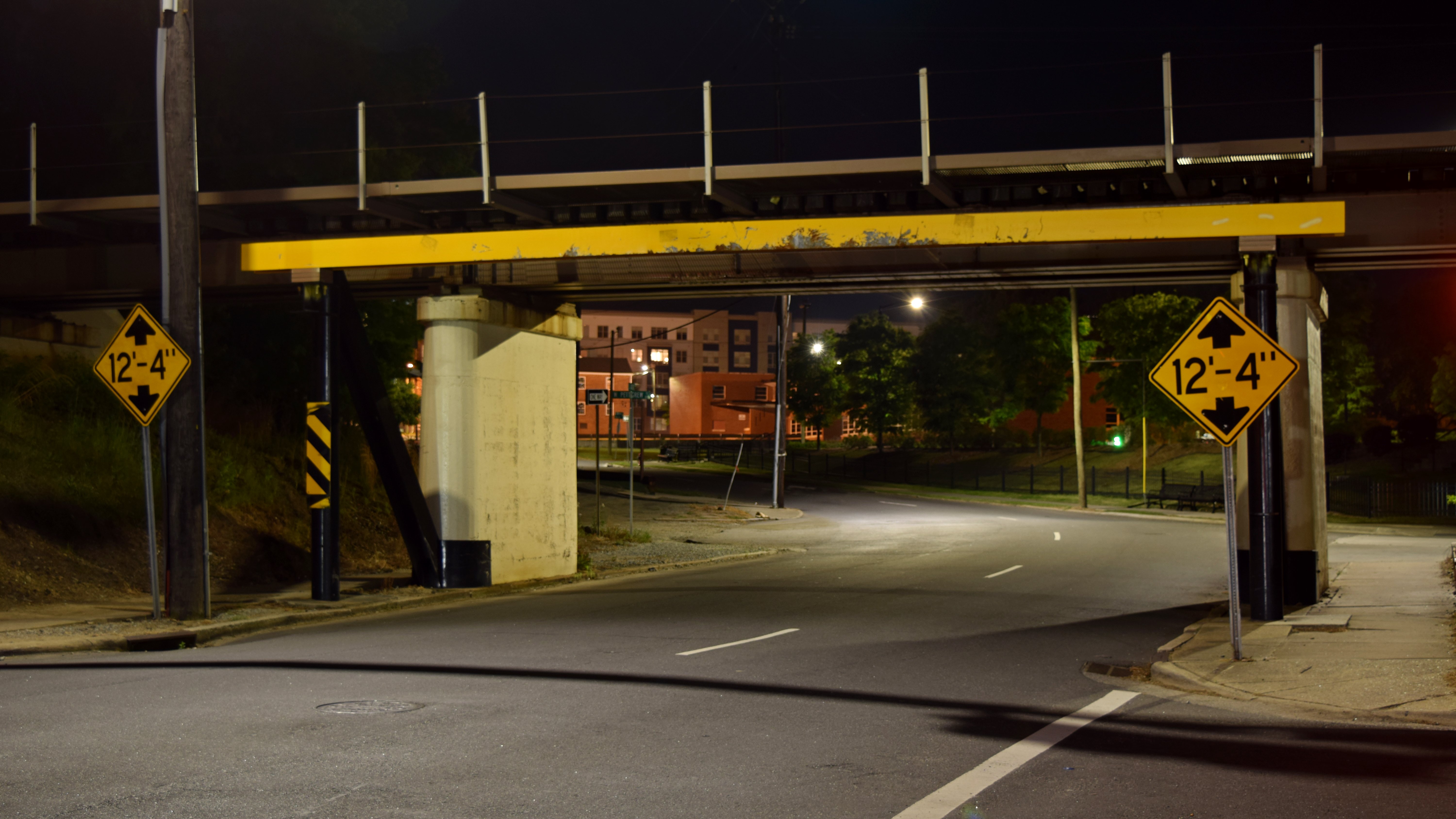
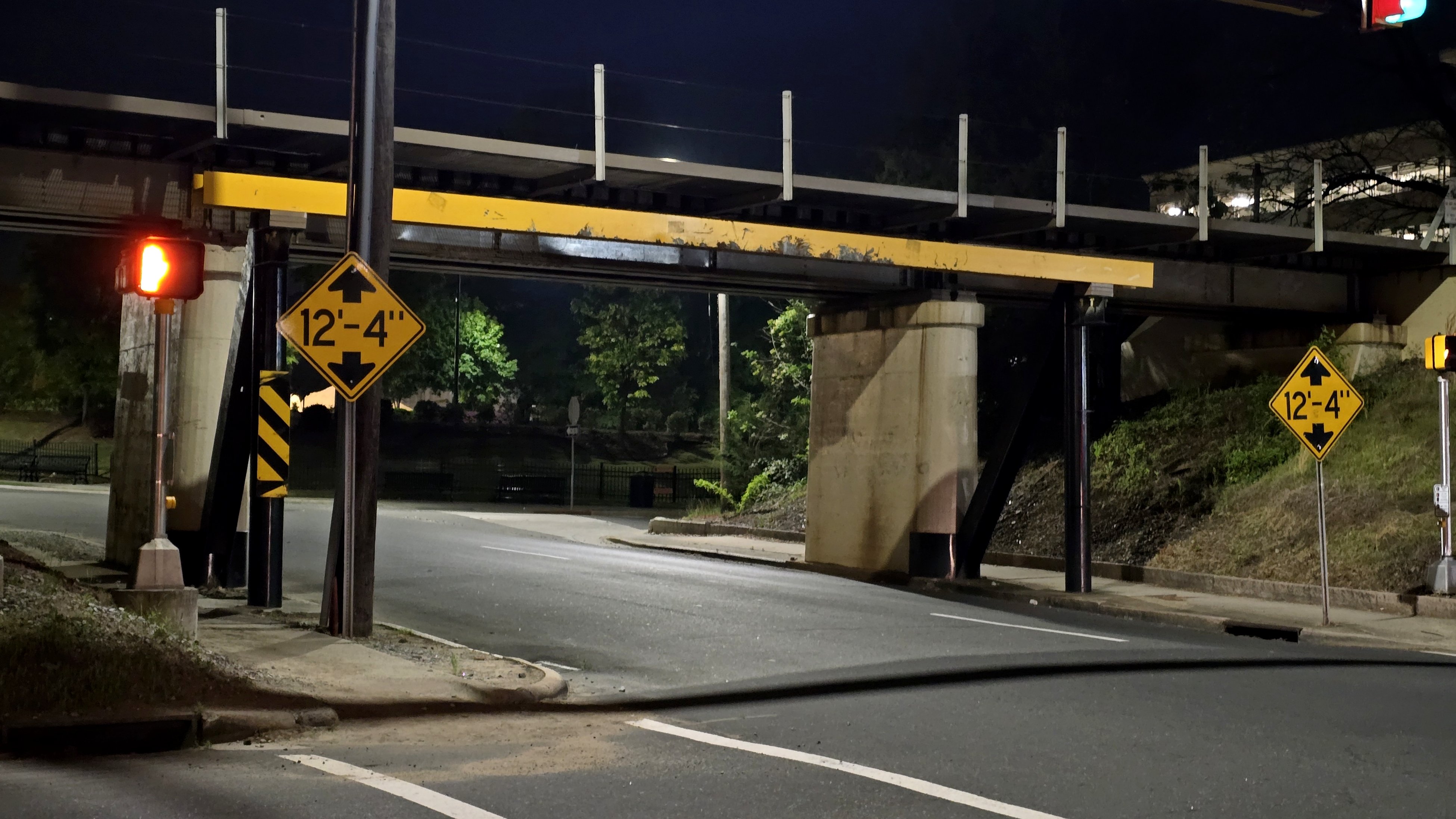
The bridge.

The 12’4″ clearance sign, which is seen in the videos about the bridge. The bridge was raised to this height from its original 11’8″ height in 2019.

Another warning sign for traffic on West Peabody Street.

Street sign at South Gregson and West Peabody Streets.

The camera that is attached to a nearby building and trained on the bridge to record all of the footage that we see.
I want to come back to Durham on a future trip, not only to photograph the bridge in daylight, but also because Durham seems like a pretty cute town. I want to explore more of it some time.
And then we got started on the final four hours home, taking I-85 to I-95. However, right out of the gate, Elyse did something that really irked me. I wanted to know how many miles there were on I-85 in North Carolina and Virginia. I wanted to know this because we were going northbound on an unfamiliar Interstate highway, and I wanted to be able to gauge when we were going to cross into Virginia, and also how far it was to the junction with I-95 in Petersburg. Going northbound, after all, the exit numbers and mileposts count upward, so I needed to know what my “end” number was, since it’s not like southbound where it counts down to zero. Would you believe that she refused to look it up for me when I asked? She told me that I didn’t need to know that. After a brief argument over why I needed the information, I was basically “screw you” about it, and pulled over and looked it up myself. Meanwhile, driving I-85 was not a fun time. It’s an extremely boring highway, and fatigue was starting to set in (another reason why I put such a high emphasis on pacing). I managed to get us to the end of I-85, and we continued nonstop through Richmond.
Then I got off at the Atlee exit and stopped at that Sheetz. There, I parked kind of off to the side and took a 30-minute nap. That did wonders for me, getting me enough rest to continue on without fear of falling asleep behind the wheel. I got something to eat, and then did the remaining 115 miles home in one shot. We arrived home at 5:30 AM, and we just went in and went to bed, leaving everything in the car until after we had properly slept.
All in all, we had a very good time on this trip, even if the pacing on the last day was absolutely awful and led to a very tiring drive home. We had such a good time that we’ve discussed doing another road trip down here for a week, with the idea of spending one day in Myrtle Beach, three days in Charleston, and one day on an outing to Savannah, Georgia. I believe that would be a lot of fun, just as long as proper pacing is maintained on travel days in order to avoid fatigue and get us to our destinations at reasonable hours.
Categories: Converted buildings, Fire alarms, Netculture, North Carolina, Photography, Retail, Roads, Ships, South Carolina, Transit, Travel