


A trip across South Jersey…
16 minute read
April 27, 2024, 9:41 AM
On April 4-5, I went on a solo trip up to New Jersey. It was a trip that I had been looking for a time to do and one that Elyse had no interest in. April 4-5 was where it fit in my schedule, so I planned it out and went. That said, I was certainly crossing my fingers and anything else that I could cross that the weather would hold out. The forecast for my travel dates would be mostly cloudy and rainy, with a possibility for some breaks in the cloud cover and precipitation. I wanted a very productive overnight trip where I came back with a nice, big photo take, and not a trip that got rained out and ended up being a scouting-future-locations kind of trip. That’s the thing about overnight trips and such: they’re planned and booked in advance, so the weather can be a bit of a roll of the dice. Sometimes you win, and sometimes you don’t.
The plan was to go up to New Jersey via I-95 (i.e. my usual route) and then go across South Jersey on the first day, ending up in Egg Harbor Township for the night. Then I was going to go down to Cape May and take the ferry across to Delaware on the second day, returning home via US 50. Elyse and I tend to call this sort of trip profile a “loop trip”, since we are more or less constantly covering new ground, and doing almost no backtracking. These sorts of trips are fun when they work out, since it eliminates the return-trip blahs, where it’s clear that the fun is largely over, and we’re just retracing our steps back home. On a loop trip, almost no road is traveled on twice.
This one was a little unusual in that I had a doctor’s appointment at the hospital in Olney first thing, so I attended to that and then left straight from the hospital. However, the ride up didn’t exactly inspire confidence in my ability to have the productive trip that I wanted, since it was raining more or less the entire way up to New Jersey. My first planned photo stop was the Church Landing Fishing Spot in Pennsville Township, where I planned to try some different angles of the Delaware Memorial Bridge with the drone, but due to bad weather, I skipped it. I’m not worried about it, though, because we visited this area once before in 2022, and I don’t expect that it’s going anywhere any time soon, i.e. I can do that on a future visit. Fortunately, the rain stopped not long after I got into New Jersey, though the cloud cover would persist for most of the day.
My journey through South Jersey took me through areas much further south than I typically go when I visit New Jersey. When I go to New Jersey, I typically find myself in Camden County, mostly centered around US 30, because I have relatives that live out that way. I also find myself going to Glassboro, where I used to live, but I’m usually somewhere in the New Jersey suburbs of Philadelphia. This trajectory largely followed NJ Route 49, US 322, and US 40, going through Pennsville, Salem, Shiloh, Bridgeton, Landisville, Mays Landing, and finally Egg Harbor Township.
My first photography stop was a fire department in Quinton Township. I was driving through the town on Route 49, and spotted a fire department with sirens. Elyse wasn’t with me, but I figured that she would appreciate seeing the sirens, so I stopped and fired up the drone for a few shots.

Federal Signal STH-10A. Considering the appearance of this siren, I suspect that this was abandoned in place a long time ago, having been replaced by the other siren.

American Signal Corporation Tempest-112 siren, with a little owl decoy bolted to the top of it to keep the birds away.
While I was there, I attracted the attention of the two small dogs who lived in the house next to the fire station, and they were barking at me most of the time I was there. I paid them no mind, though, because they barked at anything that moved, taking time to go bark at cars that passed by before coming back to bark at me some more.
I then continued down NJ 49, heading towards Shiloh. There, I photographed a vintage school located on the main drag through town.

The former Shiloh Elementary School. My understanding is that the property is now privately owned, though it is not being used for anything at this time.
After I finished photographing it with my drone, I went around a bit with my DSLR. While I was photographing with that, I noticed a device above the second-story windows in the center of the building. My DSLR couldn’t do that justice, so I went back to the car and sent the drone up again to get a closer look:

Turns out that this is a fire alarm device of some sort. It’s most likely a Federal Signal 350 horn back there, with the matching square Federal Signal projector on the front.
Then I went into Bridgeton, where I went to work photographing some of my parents’ old workplaces. Both parents were teachers until 1981, and then after I was born, Mom became a full-time parent, while Dad went into industry rather than education. Mom taught fourth grade at two different places, both in Bridgeton. The first was at Pearl Street School, which closed and was demolished decades ago, and the other was Cherry Street School, which I stopped by and photographed:
.")
.")
Cherry Street School, which looks every minute of the mid 20th century, though it appears, at least at a glance, to be well-maintained. Mom taught in that 1970s-era addition on the back of the building, which used an “open classrooms” plan (which I can almost guarantee you has been walled in since).
Then I went out to Cumberland Regional High School, where Dad taught science:

Cumberland Regional High School. This school was new when Dad taught there, having been built in the 1970s. It still looks very much like the 1970s, though it’s clearly been kept up over the years, such as the addition of a solar carport over a surface parking lot.
I didn’t spend too much time at Cumberland Regional, because I was starting to run up against the clock as far as daylight went. Next stop was in Landisville, to photograph the Scott Nonwovens facility where Dad worked after I was born:


The old Scott Nonwovens facility in Landisville. Dad worked as a lab tech here, and left in 1984 when he became the new quality manager at the Scott Nonwovens facility in Rogers, Arkansas. This facility became PGI after Scott Nonwovens was acquired by Polymer Group, Inc. which continued to operate the facility until 2008. The property now houses other industrial tenants, though interestingly, the PGI signage remains on the property.
That was the end of my photography for this day, because by the time I finished in Landisville, I had run out of light. So I put in the directions for my hotel, the Hampton Inn in Egg Harbor, and made tracks. I attempted to visit the Hamilton Mall in Mays Landing on the way past, but despite that they were supposed to be open, I couldn’t find an unlocked door. Oh, well.
The Hampton Inn was pretty much what you would expect a Hampton Inn to be like. I checked in on my phone, got settled in, and then went out to get something to eat and various provisions for the next day. Coming back, though, is when I realized that this building was actually a lot older than it otherwise was letting on, when I saw the fire alarm at the end of the corridor:


That is a Faraday 5505 horn/strobe, i.e. a Wheelock 7002T knockoff. It also makes it clear that this is a much older building than I initially thought. As is often the case, things like fire alarms and elevators will often give away the true age of a building. The alarm system, though, was quite the hodgepodge of different notification appliances, with this thing at one end of my floor, a System Sensor L Series in the middle of the floor, and a Wheelock AS at the other end. Meanwhile, next time I stay here, remind me to bring a SpectrAlert Advance and a screwdriver, and we can, um, service that thing (just kidding – that’s not how I roll).
Then the next morning, I was out of my hotel around 10:30 and hit the road, just as an earthquake occurred. I never felt it, and only found out after the fact. I was kind of disappointed to learn that I had missed it, but that’s the way it happens sometimes, I suppose. My travels were taking me to Cape May, and so I was taking the Garden State Parkway all the way to the end.
But first, I noticed a building in a nearby shopping center:

This is Umi Sushi & Seafood Buffet, housed in what is clearly a former Golden Corral building. Pretty neat.
Going down the Garden State Parkway, I noticed that some of the mileposts had an extra sign above them. I noticed it on 30, then I didn’t see it again until I got to 20. I was ready for it when I got to 10, and I got it:

There you go. Turns out that this is a Garden State Parkway shield above the milepost, but they have faded to the point that they’re basically just gold dots now.
Arriving in Cape May, I spotted this sign for County Route 651:

I saw this, and I couldn’t help but think, “You had one job,” when I saw that backwards 1 on the sign. One has to wonder how that even happens. Clearly, someone wasn’t paying attention when they loaded the stuff in for this one.
Then I pulled the drone out and did some flying, after a woman alerted me to a potential bird’s nest on a nearby cell antenna:

Turns out that it was an osprey that had a nest up there. Pretty neat.
And before anyone says anything, this was taken with my drone’s zoom lens. I maintained a respectful distance away from the bird and its nest at all times, on purpose. I admit that in the past, I’ve used my drone to deliberately scare away birds when I don’t want them in my photos, but for this one, I didn’t want to do that, because it was nesting. Clearly, it noticed my drone, but I kept far enough away that it hopefully wouldn’t see me as a threat.
Then more or less directly beneath the tower was a wastewater treatment facility:

Then just down from that was a water tower:


I don’t know about you, but I’m impressed about the people that managed to get graffiti on it in various places. I’d be too scared to go up there in the first place, let alone reach some of the places that these people reached to put their writings.
And then I made it down to the beach, where I planned to photograph the SS Atlantus. For those not familiar, the Atlantus was an experimental concrete ship that was built in 1918-1919, and retired from service in 1920 and laid up in Virginia. The ship was purchased by a private owner in 1926, with the intent of using it to help form a slip for a ferry dock. The ship ultimately broke free from its moorings during a storm, and ran aground 150 feet off of the beach. Attempts to refloat her were unsuccessful, and she remains there today, in a wrecked state.
I’m also going to admit: the Atlantus was the primary reason that I made this trip. This was one of those trips where I had an idea for something but couldn’t justify it by itself, so I found other things to photograph and then built a trip around all of it. This happens more often than you might think, and it usually works out pretty well.
So with that said, the first thing that I did was photograph the Atlantus with my DSLR:

The SS Atlantus as viewed from the beach, taken with my zoom lens.
Then I fired up the drone and went in for some closer shots. Though before I started photographing, I made a few passes fairly close to my subject to scare all of those birds away. Not only did I not want them in the shots, but I also wanted them gone to reduce the possibility of a bird strike, since that could be fatal for my drone, being over water and all.
So here’s the Atlantus:

Chasing the birds away.


Then, while I was still up in the air, I checked out the Cape May-Lewes Ferry, whose boats passed nearby:


The MV Cape Henlopen travels the southbound route to Lewes.

The MV Cape Henlopen and the MV New Jersey pass each other at sea.

The MV New Jersey travels the northbound route toward Cape May.
At that point, all of my goals had been met in Cape May, but I still had a few hours before my ferry reservation. So I checked out a nearby World War II-era lookout tower. I toured the inside of the tower, and then flew my drone around it.

The tower, viewed from the entrance walkway.
I didn’t photograph the inside of the tower at all, as the interior was completely modern, with no vintage elements remaining. I did, however, photograph out of the windows at the top:


Let’s admit: the view wasn’t amazing, but it did provide a nice enough look at the area from above.
Then after I finished up inside, I fired up the drone, and went for a quick flight:


Before I finished up, I hovered over the roof of the tower in order to get an idea of what it would look like standing on the roof. I kind of liked this view, with the railing in the shot.
Following this, I left Cape May for a little while (though I would have to return for the ferry). I headed up to Wildwood, where I didn’t have a whole lot of time, but had one specific goal in mind: photographing the Wawa. For those not familiar, the Wawa on West Rio Grande Avenue in Wildwood has very unique signage, and is worth a photograph. The interior of the store is nothing special, as it’s a standard Wawa on the inside in every way.


It’s certainly a unique style, but I like it all the same. My understanding is that this design was made to sort of harmonize with a midcentury design feel in Wildwood.
I admit that the clouds kind of dampened my photos, but I did well enough. I would love to spend more time in Wildwood in the future, though, because there’s a lot of charming architecture there that I want to see, but that I didn’t have time to fully explore. So after photographing the Wawa and having lunch, I headed back to Cape May.
In Cape May, I headed over to the lighthouse. I had two goals there. One was to photograph the lighthouse, and the other was to photograph the southernmost tip of New Jersey. I did the southernmost point first:

The end of Cape May, which forms the southernmost point in New Jersey. The only thing that I can say about it is, “Here it is.” I found the results of this flight to be disappointing. I suspect that if the FAA allowed me to go a bit higher than 400 feet, I could have captured something very dramatic, but failing that, here we are.

I did a bit better catching an aerial view of the town on the way back, though the clouds still put a bit of a damper on things.
Then here is the lighthouse:


I got finished just in time, too, as it started to rain just as the drone touched down. That was fine, though, because my time in Cape May had run out, and it was time to start heading over to the ferry terminal.

On the way to the ferry terminal, I dipped into a nearby shopping center to use the restroom, and spotted Yozu Sushi, a Japanese restaurant housed in a former KFC building.

Waiting in the lane to board the ferry.

What I did while I waited to board the ferry. The way I saw it, I had the time and a strong signal, so I offloaded the photos from the phone, the DSLR, and the drone, and started the upload process to the cloud. Unlimited data for the win.
The ferry that I got was the New Jersey, which I photographed with the drone earlier in the day. Once the HR-V was settled, sandwiched in between a truck and an RV, I got out and started exploring around the ferry, photographing whatever I found interesting.

Toilet in the men’s restroom on the New Jersey. I found it interesting that it was more than a foot away from the wall.

In the gift shop, I found a new octopus friend. His name is Paul. After acquiring him, I placed him in the HR-V for safekeeping. Elyse especially loves Paul’s little hat.

The fantail on the New Jersey, with the sea gulls flying behind us.

Motor launch on the New Jersey.
 tanker, at the beginning of a voyage to Sweden.")
The GasChem Europe, a Liberian-flagged LPG (liquefied petroleum gas) tanker, at the beginning of a voyage to Sweden.
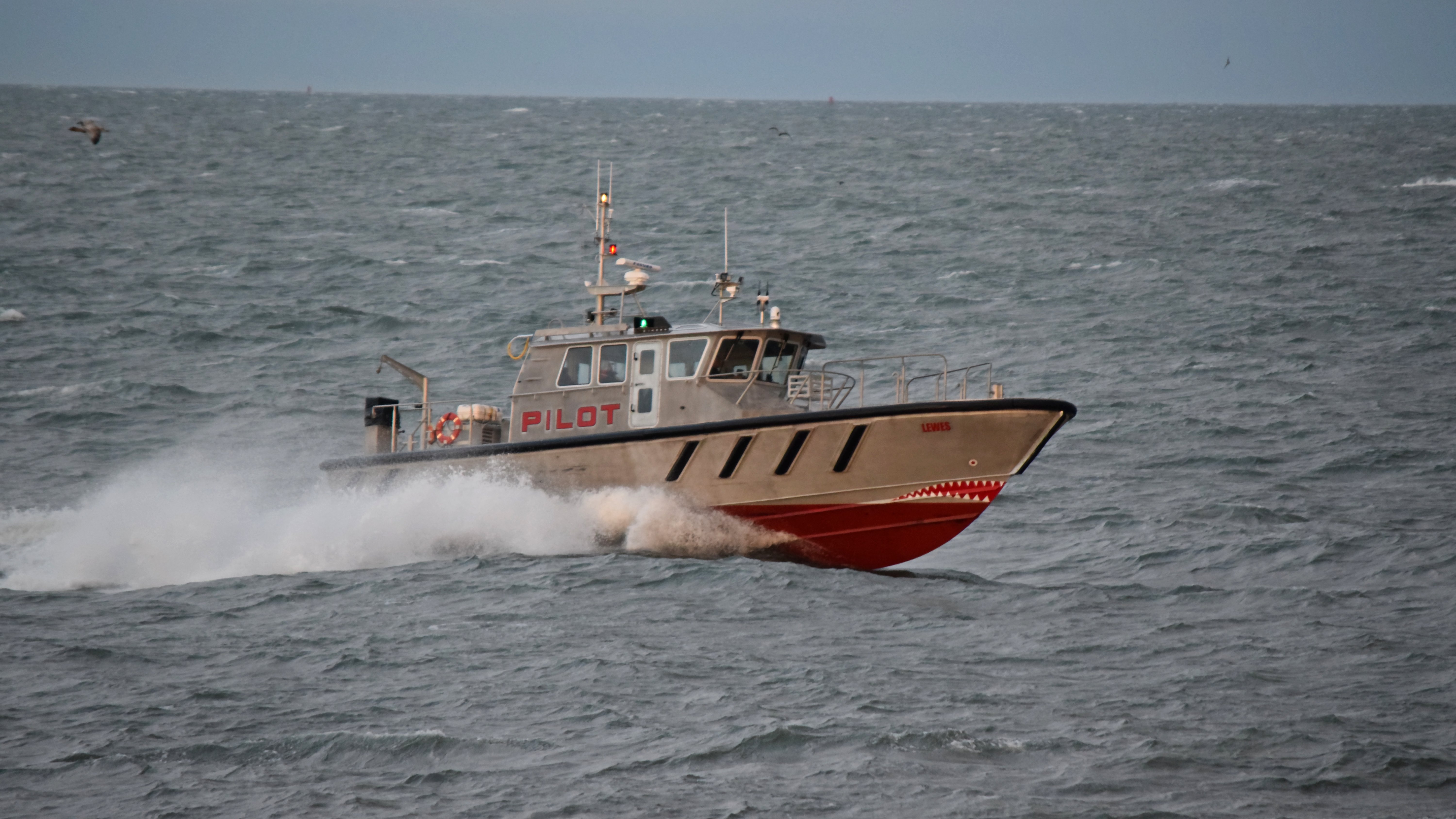
As we approached Lewes, I spotted the Lewes, a brand new Chesapeake-class pilot boat.

General alarm horn on the New Jersey.

The sunset, as viewed from the ferry. Yes, the clouds cleared just as it was getting dark. It figures, but it certainly made for a gorgeous sunset.

The sunset, with a coin-operated viewer in the foreground.

The HR-V on the vehicle deck, just prior to our arrival.
After landing in Lewes, the ferry boarded for one more trip back to Cape May before the service day was over. Meanwhile, now in Delaware, I headed out. All of my main photography objectives were completed, and so I pulled into a nearby parking lot and offloaded the ferry photos to the tablet and let that work for a while. I had no expectation that everything would upload by the time that I got home, considering that I would be driving through some sparsely populated areas, but it at least gave me something of a leg up on getting things in place.
Once I got that taken care of, I was in Lewes and it was about 7:45 PM, and it was time to start thinking about what I wanted to do in Delaware and then start making moves towards home. I ended up hitting up an Acme store in Rehoboth on the way through, where I picked up a few odds and ends, and then visited the resort area in Rehoboth, where I took a quick walk around and got a few photos.

A peek inside the window of Gus & Gus Place. The place looks vintage, and based on how difficult it was to get a clear-ish shot of the place through the window, it looks like they haven’t cleaned their windows in ages.

Sign at Tidal Rave’s 5 & 10, admonishing customers not to open toys, and warning that if they do open something, they are obligated to buy it. I always wonder if these sorts of policies are legally enforceable, but I’m guessing not.

Penny Lane Mall.
Then I headed down Delaware Route 1 to Ocean City, where it becomes Maryland Route 528. I figured, let’s make it complete and go through Ocean City. I knew that it was starting to get late (I left Rehoboth just after 9:30), so I didn’t expect much. I dipped into a Wawa to gas up for the ride home, and then stopped at a nearby Food Lion for a few more odds and ends. Then as far as photography went, I only photographed one thing:
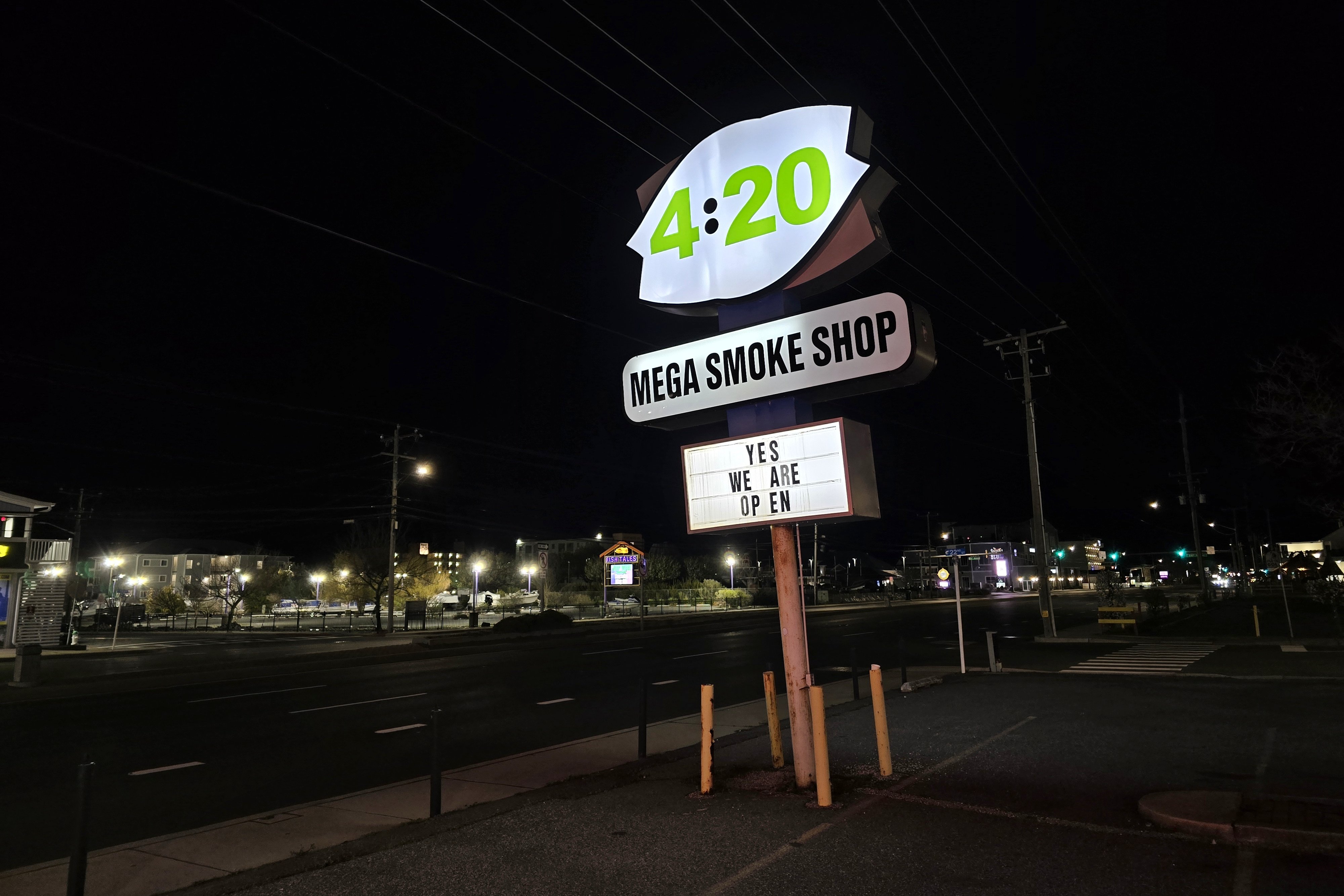
This is the sign for 4:20 Mega Smoke Shop, in a frame clearly intended for a Dairy Queen (and on my last visit to Ocean City, it still was Dairy Queen).
And then from there, I went to the bottom of Ocean City, looped around, and then got on US 50 and headed west. I made a stop in Salisbury to go to Cook Out, but other than that, along with a stop just before the Bay Bridge to get up and walk around a little bit, I just plowed on through to get home. This was a fun little adventure, and I accomplished a number of things that I had wanted to do for a while. I don’t do two-day overnight trips all that often because it’s very easy to overload them, which often causes me to rework them into three-day weekend trips. But this one worked out perfectly, as I got a lot of stuff done, and I got ideas for things that I want to do in the future.
Categories: Delaware, Family, New Jersey, Ocean City, Photography, Ships, Travel