A weekend in Augusta County, unsupervised…
28 minute read
December 22, 2023, 5:00 PM
I did my quarterly trip down to Augusta County on December 13-15, and this time, unlike most occasions when I do this trip, I was doing it completely unsupervised. Elyse was pet-sitting for a friend of ours, and so she was in Fort Washington while I went down to Virginia. With that in mind, I took full advantage of this situation, packing in all of the stuff that I would want to do that Elyse would probably not have the patience for. In other words, lots of drone photography, mostly photographing Augusta County school buildings, with the thought’s being that very few people would get good aerials of these relatively small schools. I had a good time, and I felt very productive.
I got out of the house around 11:00, and then hit the road. This was a trip where I went down via US 29 and back via I-81, and things immediately did not look good, as I encountered major traffic on the Beltway. That was annoying, but I recovered well enough, though I did start to contemplate how much of a difference it would have made to go an alternate route for a Charlottesville trajectory, with the thought’s being to 270 to 15 to 29, going via Point of Rocks and Leesburg, or something similar to that. After all, the alternate route works well when I’m going to I-81. That alternate route bypasses the Beltway and I-66, going to I-81 via US 340 and Route 7 via Harpers Ferry and Winchester, and only adds seven minutes to the trip. I ran my proposed alternate route for 29 through Google, and it adds about thirty minutes to the drive to go across Montgomery and Frederick counties via local roads, and then 15 at Point of Rocks, and joining 29 just south of Haymarket. This also bypasses the busiest part of my route on 29, in the Gainesville area. The question really becomes a matter of whether this alternate route is worth the additional time to travel it vs. dealing with the annoyances of the Beltway and 66, as well as the additional cost involved with taking the express lanes.
In any case, once I got to the express lanes on the Beltway, I took them, and continued in the express lanes on I-66, because I didn’t want to risk any more delays. I made a pit stop at the Sheetz in Haymarket, and then from there, I took 15 to 29 and then the rest was normal for a trip down via 29. The plan was to dip into Warrenton on the way down to photograph some converted restaurant buildings. I had spotted a few of these on past drives through Warrenton, and now I was going to do them, along with whatever else I found interesting on the way down. This was also why I hit up the Sheetz in Haymarket rather than the third Sheetz (Bealeton) like I normally would. Warrenton came before the third Sheetz, and I wanted some food inside of me before I got busy.
So here’s what I got in Warrenton.
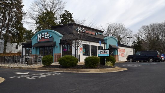
Moe’s Southwest Grill, housed in a former Pizza Hut. Google Street View shows it as Pizza Hut as recently as 2018.
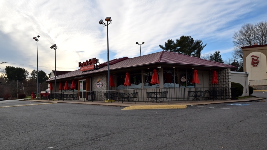
Foster’s Grille, housed in a former Howard Johnson’s restaurant. Foster’s has been in this building since the late nineties, according to Highway Host.
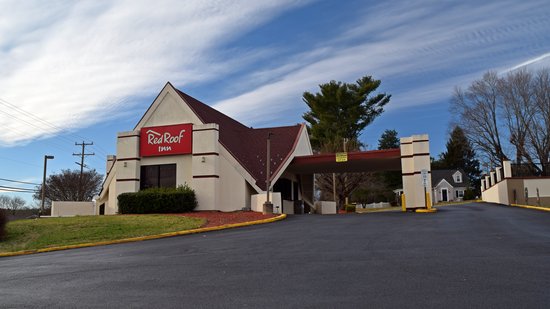
The accompanying Howard Johnson’s motor lodge, now branded as a Red Roof Inn. According to Google Street View, the motor lodge was still a Howard Johnson’s as recently as 2018, but by 2021, it had rebranded to Red Roof Inn.

“Bow tie” sign for Tom Frost Firestone. This isn’t a converted building – just a cool sign. According to a gentleman working there, the sign dates back to 1965.
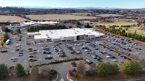
The Walmart in Warrenton, photographed with the new drone. This is a Supercenter conversion, having been converted during the Project Impact era. This store used to have a reddish exterior, and always had an open-truss ceiling on the inside. As such, it is nearly impossible to tell now that this store was not originally built as a Supercenter.
Then I continued on until I reached the third Sheetz. There, I parked across the street, and went for another flight around that area.
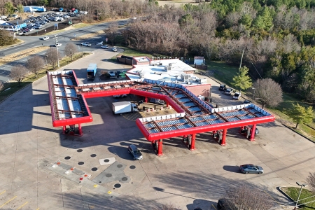
The third Sheetz. I wanted to make sure to fly this and get some photos, because the last time I was through here, I had been told by an employee that there were plans to do a demo/rebuild on this location, as this is still very much an older store, despite having been updated numerous times over the years. Thus I felt it necessary to document it in the daytime before it was replaced.
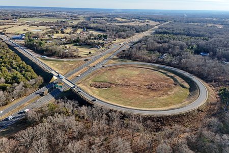
Loop ramp for traffic going from southbound US 29/US 15 to southbound US 17. The intersection between 17 and 29 is an unusual one. Traffic going northbound on US 17, called Marsh Road at that location, simply travels to the signalized intersection between Marsh Road and 15/29, and makes a right at the third Sheetz to continue. Southbound traffic cannot reach US 17 by turning onto Marsh Road, though, as Marsh Road is only US 17 northbound. Going the other way on Marsh Road, the road provides access to some local businesses and then just turns you back around onto northbound 17. To continue on US 17 southbound, you have to go another half a mile south, down to this interchange, and then take the loop ramp around and join Marsh Road a little bit further to the east. I suppose that this was done to alleviate congestion at the intersection where the third Sheetz is, but it seems less than intuitive in its design.
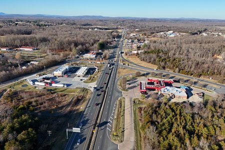
Intersection of 29/15 and northbound US 17. The third Sheetz is to the right, and a Royal Farms is located across the street.
Continuing on, I then stopped in Culpeper for more photography. I had downtown Culpeper on my list, but I was starting to run up against the clock as far as usable daylight went, as downtowns, with their denser development, usually need the sun in a higher position in order to photograph well. I was a bit past that time, unfortunately (around 3 PM), but such is what happens when you’re photographing this time of year when it gets dark early. So downtown Culpeper mostly ended up back in the pool of photo ideas, to do at a later date. These things happen, and I suspect that Culpeper isn’t going anywhere any time soon. And Culpeper is somewhere that I could do almost any time, and I should do a dedicated day down there some time. It’s only about an hour and a half away. Elyse and I treat the Carworks building just north of Culpeper as a landmark denoting the midpoint of our trip when taking the 29 route, so it really isn’t too bad, as it’s about halfway to Staunton, which we really could reach without much difficulty. Plus there are other things that we could do along the way there or back that would make for a nice, well-rounded day. We should do that some time.
Failing to get downtown Culpeper, though, I ended up flying the Lidl store instead:
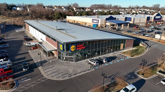
The Lidl store in Culpeper. I’ve wanted to get this style of Lidl store with the arched roof for a while, but Lidl is really weird about people photographing their stores, so I put the drone in the air to get my shots, flying from across the street. In other words, good luck finding me, and if you do, buzz off, because I’m not on your property.
Then I continued down the road until I got to Charlottesville.
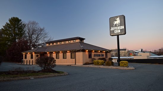
Jefferson Coin on US 29 in Charlottesville, housed in a former Pizza Hut. According to Google Street View, this location was Pizza Hut as recently as 2012.

Interior of the former JCPenney at Fashion Square Mall in Charlottesville. My understanding is that the building has been leased to Albemarle County for use as a fleet servicing facility, though clearly, no work has yet occurred to convert it.
I have mixed feelings about these sorts of uses. On one hand, this does put the building to productive use. However, I feel that a nontraditional use like this for an anchor store building is bad for the mall as a whole, because it is not drawing any customers into the mall and helping the other tenants out.
Meanwhile, Fashion Square seemed to be doing better overall than it was the last time I was there, in 2021. There were fewer empty storefronts now than there were two years ago, but it still strongly resembled a mall that was long past its prime. They also had security guards with nothing to do, and they were big on not photographing, as I got busted for taking this shot of the former Penney’s (but they were nice about it). I feel like enforcing no-photography policies in the modern era of social media is a bit ridiculous, with everyone’s having a camera in their pocket via their phone, but it’s their property, so they can do what they want with it, as idiotic as it is (the usual rationale is that anyone photographing in a retail facility is committing industrial espionage).
From there, I went over the mountain and located the entrance to the new Sunset Park in Waynesboro. It was getting later in the evening and already completely dark, so I didn’t check it out then, but I knew where it was for later. Then I dipped into Walmart (my ex-store) for a few odds and ends, and then headed to Staunton to check into my hotel. I was planning to photograph the watering can all lit up at night, but then I decided, (A) it was too cold, and (B) the watering can would still be there tomorrow.
Thursday was an all-photography day. I had a full manifest, and I was determined to get as much of it done as I could. It was a beautiful day, but due to the time of year, the amount of sunlight that I had to work with was limited, and I was determined to get good use out of as much of it as I could.

Breakfast from Cranberry’s in Staunton. This is salmon and eggs on avocado toast.
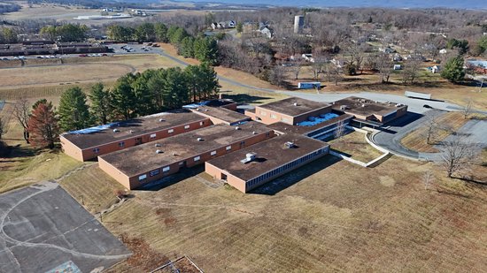
The former Beverley Manor Elementary School. This school opened in 1961 as Central Augusta High School, serving as the public school for Black students. That role ended when the county schools were integrated in 1966, and the building was later repurposed as Beverley Manor Elementary School. The county closed Beverley Manor Elementary in 2017, and the property was sold to Grace Christian School, which will relocate to that facility following renovations to the building.
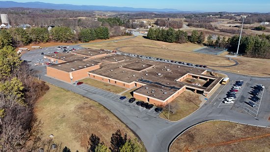
Beverley Manor Middle School. This was the last of three middle schools that Augusta County built to the same design, opening in 1989. The floorplan of Beverley Manor is reversed from that of Stuarts Draft Middle School, where I attended, but is otherwise the same. Interestingly, like Stuarts Draft, Beverley Manor was also enlarged in 1993, though in a different way than Stuarts Draft, with what appears to be a four-classroom addition on one side of the building. Stuarts Draft had an eight-classroom addition built on two different sides of the building. Beverley Manor is slated to close following the construction of middle school wings at Buffalo Gap and Riverheads high schools.
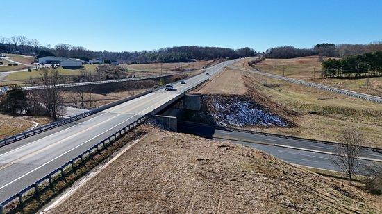
State Route 262, at the interchange with Churchville Avenue (US 250). SR 262 forms a partial beltway around Staunton, and takes several forms. The southern end of the route is built to full freeway standards. The middle part of the route is a two-lane expressway, or “Super 2”. Basically, it has all of the characteristics of a freeway, with grade separations and limited access, but only one lane in each direction, separated by a double line. The right of way is graded for two more lanes to be built in the future, but these lanes are as of yet unbuilt, though a widening project is underway at the southern end of this section. Then the northern end of the route is a local road. If all of this sounds familiar, I wrote about this back in 2006 when the full road was completed. This photo shows the bridge over Churchville Avenue in the “Super 2” part of the road, showing how the road is graded for a future second carriageway, including provisions for a second bridge.
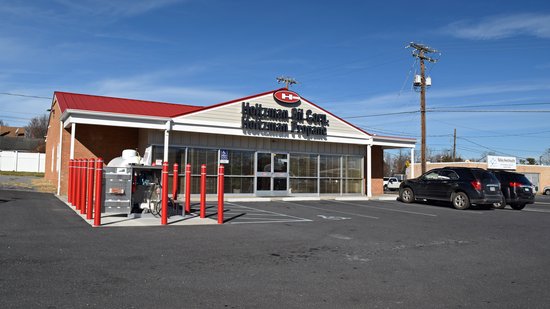
Holtzman Propane building in Verona, housed in a former 7-Eleven. This building was still 7-Eleven as recently as 2012, according to Google Street View.
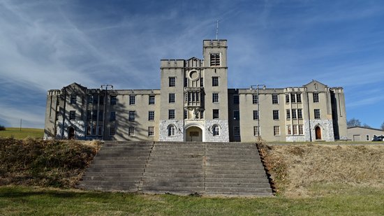
Augusta Military Academy was an unplanned stop. I flew the drone around, and also got out and photographed the main barracks building, shown here. I was surprised to find out a few things about this building. First, the building is hollow on the inside, as much of the space inside the walls is a large center courtyard. Second, this building is disused. This is the most visible building from the road, and it’s not used. The other buildings on the property are all in active use by a museum and a conference center, but this one is not.
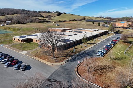
S. Gordon Stewart Middle School, in Fort Defiance, Virginia. This was the second of the three largely identical middle schools to open, and also has a floor plan that is reversed from that of my old middle school. This is the only one of the three middle schools that was never enlarged at some point in its history. Additionally, unlike the other two schools, this building lacks a canopy over the bus entrance.
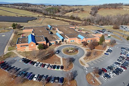
Edward G. Clymore Elementary School, opened in 1995 and named for the superintendent of schools at the time that the school was built.
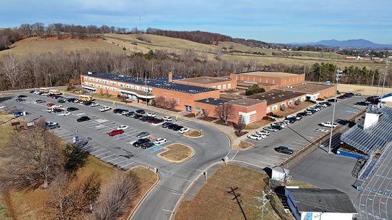
Fort Defiance High School. This is the county’s largest high school, built in the 1960s and renovated to its current form in the 1990s.
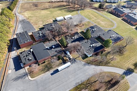
The former Verona Elementary School, along Route 11 in Verona. This is one of four “pod schools” that the county built in the 1960s. The others were Ladd Elementary, Hugh K. Cassell Elementary, and Riverheads Elementary. All of these pod schools closed in the 2010s, with students and staff’s being redistributed amongst other schools in the case of Verona and Ladd, or relocating to new buildings on the same property, as was the case with Cassell and Riverheads. Of these schools, the new Cassell was built on athletic fields, and the old building was razed to create new athletic fields. The Ladd property was sold to a developer and razed, with a row of different businesses’ now occupying the site. The old Riverheads building is still extant, but is slated for demolition in the future. Verona, meanwhile, will be renovated to house the Shenandoah Valley Animal Services Center.
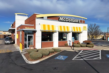
McDonald’s restaurant in Verona, built to the “Forever Young” design. Some might find it surprising that this was a drone mission. I had previously photographed this building in September 2022, but the photos were not great, and therefore were never published. The lighting was not favorable, and I also attracted the attention of some employees who questioned who I worked for and why I was photographing their restaurant. I generally want to be left alone while I’m photographing so as to maintain concentration, so this time, I stationed myself across the street and flew from the car. The idea is that even if someone was bothered by my photography of the restaurant, you might see my drone, but good luck finding me, since I had concealed myself fairly well. In other words, no one is going to bug me. I also had favorable lighting, which I greatly appreciated.
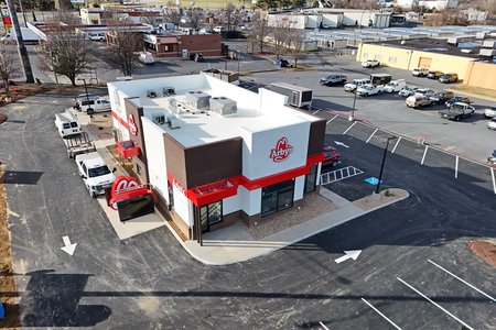
A new Arby’s under construction, two lots east of the McDonald’s, which I spotted from a distance on the drone’s camera while I was flying around the McDonald’s. I found this interesting because this is not Verona’s first time hosting an Arby’s. An Arby’s operated for a relatively short time in the nineties about three-quarters of a mile northwest of this site. That original Arby’s location closed when the franchisee opted to convert the location to Burger King. This location is closer to the freeway, while the old Arby’s was more of a “downtown” location. Maybe an Arby’s will have more success here than they did at the original location. I suppose that we’ll all find out together.
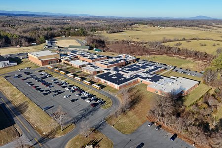
Wilson Memorial High School, which serves students in the Fishersville area. This school was built in 1970 and renovated in the mid 2000s. It was identical to Stuarts Draft High School as originally built, and with only minor differences post-renovation (both schools were constructed and later renovated at the same time).
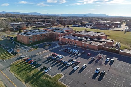
Wilson Middle School, across the street from Wilson Memorial High School, opened in 2006 and was enlarged in the 2010s. This was the long-awaited fourth middle school (I wrote about this in 2003) intended to alleviate overcrowding at Stuarts Draft Middle School. Prior to Wilson Middle School’s construction, Stuarts Draft Middle School housed students coming from several different elementary schools across the county, and then after eighth grade, the classes split between Stuarts Draft and Wilson Memorial High Schools. This school eliminated that split, as students in the Fishersville area now went to Wilson Middle School and then on to Wilson Memorial High School, while Stuarts Draft Middle School and Stuarts Draft High School served students in the Stuarts Draft area.
One thing that I’ve noticed with Augusta County Public Schools is that planning for growth is not their strong suit. Stuarts Draft Middle School was overcrowded in 1992-1993 when its addition of eight classrooms was built, and remained overcrowded the first year after the addition was completed, i.e. it was a band-aid solution when they really needed another middle school in Fishersville, even back then. Similarly, when the current Stuarts Draft Elementary School building opened in 1995, replacing an older school along Draft Avenue, the building was overcrowded in its first year of operation, which led to the renovation and reopening of the older facility as Guy K. Stump Elementary four years later.
Additionally, if you can’t tell already, Augusta County tends to get good use out of a school building design, as it rarely only builds a design once, typically building at least two schools to the same design with only minor cosmetic differences. I suppose that’s pretty efficient of them.
From here, I headed over to the Augusta County Library. I had wanted to check on the status of a Dover Impulse elevator that I remembered from the nineties, and was pleased to find that it was. I then proceeded to film it in the way that most elevator filmers do:
I feel like it is very unlike me to take video of an elevator (I prefer shooting stills), but considering that the likelihood is fairly low that Elyse will get to see it any time soon just because of schedules and such, I filmed a ride. I found it interesting that the chimes on both sides go off at once regardless of which side opens. Additionally, the buzzer between floors is different than anything that I’ve ever heard before on an Impulse.
After this, I headed into Waynesboro to check out Sunset Park. Since I had already located the entrance, I went straight on in. I had previously flown a drone up there, but this was my first time physically going up there. The park was clearly still under construction, but I definitely saw potential at the site. Here’s what I found:
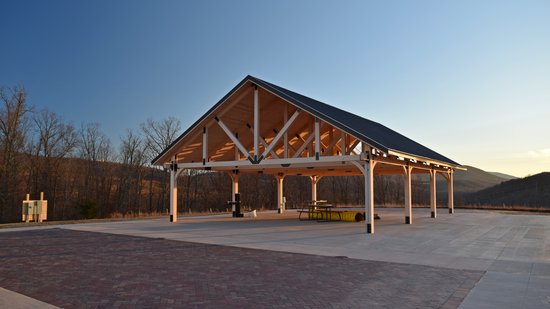
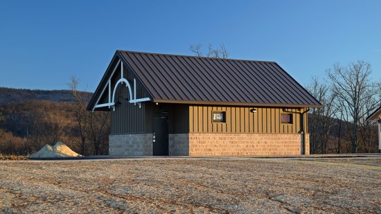
Picnic shelter. This structure is very visible from the town below.
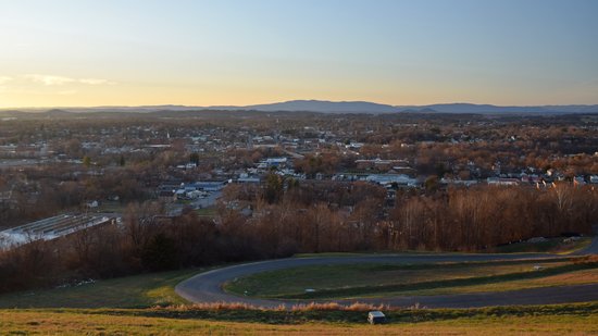
The view of Waynesboro from the park. One complaint: at sunset, the sun is directly in your face when you’re looking out on the overlook. Such is what happens when your view is oriented west, I suppose.
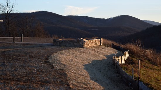
One of two overlooks at Sunset Park.
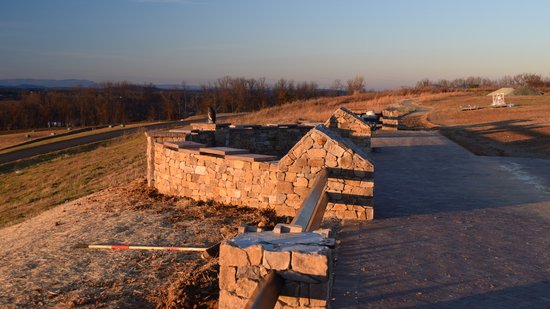
The other overlook at Sunset Park.
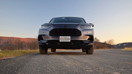
Once I was finished photographing the park, I stopped partway down the hill and got some shots of the HR-V:
I love the way that the HR-V looks in the sunset, and the slightly more muscular look of the new HR-V compared to the original HR-V really makes it photograph well.
That was the end of my day as far as photography went. I had a meal at McAlister’s Deli in Waynesboro, hit up the Staunton Walmart to check on something for Elyse, and then headed back to my hotel. I again decided to skip the watering can, because it was even colder than the night before, and the watering can still wasn’t going anywhere. I suppose that’s something to do on a future trip when it’s warmer out.
On Friday, I got out of the hotel just before 10 AM. The plan was to do a reshoot of some subjects that I had taken with unfavorable light in September due to my getting there too late in the day, pick up Mom at the house, and then do some more drone photography, similar to what I had done the day before. After all, I had two more high schools that I had planned to fly, and one more middle school.
But before any drone took to the skies, I did the reshoot. That had some personal significance, as the subjects of this work were three people that I went to school with who had died young: Billy Critzer, Charity Billings, and Miriam Shifflett. Billy was a year behind me, and died at age 24, a number of years after we had all graduated. Charity was in my graduating class, and died in August 1999, the summer after our senior year. Miriam was two years ahead of me, and died in October 1996, in the fall of her senior year. I do not know the cause of death for any of them.
I had originally photographed these graves on the afternoon of September 15, during my previous visit down this way. The sun was behind the headstones at that time, which tended to black out what I was trying to photograph. I quickly recognized that I would need to photograph these in the morning in order to get the right kind of light, but this was not possible on the September trip, as I had planned the photo shoot on the last day of that trip. This time around, I got to the first cemetery, Augusta Memorial Park in Fishersville, around 10:15 AM, and arrived at the second one, Riverview Cemetery in Waynesboro, just before 11:00. So as far as lighting went, I was all set.
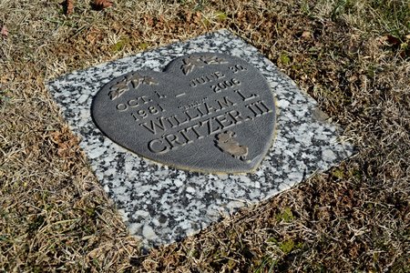
Billy Critzer’s marker at Augusta Memorial Park. Of the three, I probably knew Billy the best, having interacted with him on numerous occasions in both middle school and high school. He was a good kid overall, but later in high school, he tended to associate with a group of kids who would wear black clothes and trenchcoats, which was the style in that subculture back then. All of the people in that group were also good kids, but because of their appearance, that group ended up attracting some unwarranted scrutiny in the wake of the Columbine High School shootings, and Billy got caught up in the same sort of thing that happened to a friend of mine who ran his mouth about Columbine following that event, and their commentary was deemed enough to warrant legal action. Billy got it a lot less than my friend did, since he was still underage at the time, and was back in school a week or so later. My friend, being 18, had his face plastered all over the local news, and never returned to school after that. I did not learn of Billy’s death until fairly recently, when someone on Facebook mentioned him and how he was no longer with us, as we had lost contact after high school.
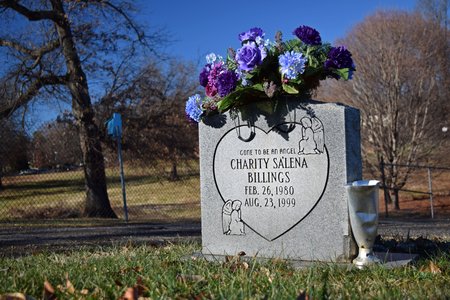
Charity Billings’ grave marker at Riverview Cemetery in Waynesboro. Of the three, I knew Charity the least well. We were in the same graduating class, and with the same team of teachers in sixth grade, and we certainly both knew of each other (i.e. each knew that the other existed), but I don’t believe that we ever actually interacted with each other. No particular reason – our paths just never crossed. Other friends of mine have shared fond memories of her from our school days, but I never really knew her all that well. I just remember being very surprised to open the paper one day the summer after graduation and seeing her name and photo in the obituaries section.
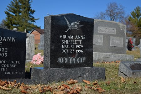
Miriam Shifflett’s headstone, also at Riverview Cemetery. Of the three, Miriam’s death hit me the hardest. I had Spanish class with her in the first semester of my ninth grade year, and she sat right next to me, to my left. I remember that she was taking Spanish after having taken some semesters of Latin, and tended to mix up certain differences in pronunciation between Latin and Spanish, particularly with the letter “C”. In Latin, C is always pronounced with the hard sound, i.e. like “K”, regardless of what letter follows it. Spanish is like English in its treatment of C, in that C is pronounced with the soft “S” sound if it’s followed by an “E” or an “I”. I remember our teacher’s mentioning that she would have to give Mr. Popeck (the Latin teacher) a hard time about that. Miriam died in late October of the following school year, while she was a senior and I was a sophomore. Her death occurred over a weekend, and it was announced at the beginning of second block that Monday. I was taking Latin that semester, and as such, I had Mr. Popeck second block, when he, along with all other faculty that had classes that period, was tasked with announcing her death to the students. Mr. Popeck had taught Miriam in Latin class for a few semesters, and I remember that her death hit him very hard, as it really took the wind out of his sails that day – and understandably so. It hit me significantly as well (though not as hard as it did Mr. Popeck), because I had known her through our time together in Spanish class. We had chatted together, we had practiced our Spanish together, and we had laughed together in that class, and now, all of a sudden, she was gone. Someone had taped a rose to her locker following her death, and her funeral was held the following Friday, with many students, as well as some faculty, taking the morning off to attend.
In visiting Charity and Miriam’s graves at Riverview Cemetery, I had a very sobering realization: these two classmates of mine had now been gone for longer than they had been alive, and that these markers have now been their presence in this world for longer than they themselves were present in this world. It really reminds you that life is precious, and you really never know when it will be over.
Finishing at the cemeteries, I went elsewhere in Waynesboro to photograph a street sign for a road with a very unusual name:
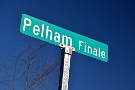
Welcome to Pelham Finale. This is the name for the cul-de-sac at the end of Pelham Drive, which runs for just under a mile north and east from West Main Street, across from Lew DeWitt Boulevard. Pelham Drive is the main road through the Pelham Village subdivision, which is a fairly well-to-do neighborhood in Waynesboro. The houses at the end of Pelham Drive, as well as on Pelham Finale and nearby Pelham Inlet (another weird street suffix), particularly exemplify this, as they are much grander than the houses in the front part of the neighborhood.
Then I went down to Stuarts Draft, dipped into Sheetz to pick up something for lunch, and headed over to the house to get Mom. We had lunch together there, and then we got going again. Mom had to return something at Country Connections, which is a little store near their house, and then we continued down the road, as I had drone flights to complete. We headed down near Greenville, where there were two schools that I had planned to fly.
One thing that Mom didn’t really get to see when it came to flying schools was my searching for suitable flying locations. When it came to these school flights, I was flying strictly from off-property, i.e. I’m not rolling up into their parking lot and launching from there, especially when school was in session, as was the case here. At Beverley Manor and Fort Defiance, the hardest part was finding a suitable place to park the car and operate from, considering the need for line of sight as required by the FAA, as well as clear transmission. Actually flying the flights and shooting the imagery was easy by comparison. At Riverheads, I lucked out, as there was a large pull-off directly across Route 11 from Riverheads. That space was not only large enough to safely pull off of the road, but I was also able to orient the HR-V perpendicular to the road in order to face Riverheads directly (even better!).
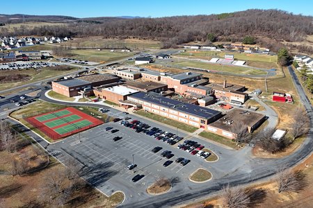
Riverheads High School. Of the three schools built to this general design, Riverheads was the smallest of the three (Fort Defiance was largest, and Buffalo Gap was mid-sized). Like the other two, the school was built in the 1960s, and renovated in the mid 1990s. At the time that I flew around, a middle school wing was being constructed behind the main school building. My understanding is that when this middle school wing is completed, the middle and high schools will share certain services, such as for food prep, but will otherwise be operated as two separate schools that just happen to share a campus. The old Riverheads Elementary School, a pod school, is visible in the distance.
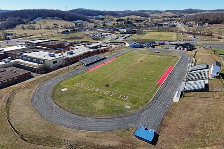
The football stadium at Riverheads. I was impressed by the design painted onto the field, looking like a serious football stadium. For what it’s worth, Riverheads’ football team did very well this year, going all the way to the state championship, though they ultimately lost the championship game to Radford. So apparently, they are deserving of a serious paint job on their field. This design only appears in recent years, based on historical overhead views. By comparison, Stuarts Draft High School, where I went, has never had the team name painted on the field like this, though it has had the lines painted at various times.
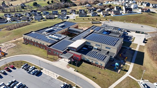
The new Riverheads Elementary School. This school was built on open land to the west of Riverheads High School. Interestingly enough, my eighth grade homeroom teacher is now the principal here.
Finishing up there, I landed the drone on top of the HR-V, and then pulled it back in through the moon roof. Mom was impressed by the way that I handled that, with my never having to get out of my seat. That was all that we were flying in that area, and so we headed back into Stuarts Draft to go to our next target. On the way, we made two stops: one at the Ace Hardware so that Mom could get a bird feeder, and then at Starbucks.
And yes, folks, you read that right. I said that we went to Starbucks in Stuarts Draft. Let that sink in for a moment. Starbucks has a location in Stuarts Draft. I never thought that I would see the day that Starbucks would open a location in Stuarts Draft, and therefore, I never thought I would say “Starbucks” and “Stuarts Draft” in the same sentence. When we first moved to the area in 1992, the only chain restaurants in town were Hardee’s, Subway, and Tastee-Freez. Now there are several more, including Arby’s, Dairy Queen, Domino’s, Pizza Hut, Papa John’s, and now Starbucks. Surprisingly, Stuarts Draft still doesn’t have a McDonald’s or a Burger King, because I would have expected one of those brands to come to Stuarts Draft before Starbucks, but here we are.
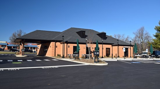
The new Starbucks in Stuarts Draft. This is a conversion of the old Planters Bank & Trust branch, which is where my parents chose to do their banking when we first moved to the area. I also set up my first checking and savings accounts here in 1997, however, I left the bank in 1999 in favor of a Harrisonburg-based credit union due to Planters’ not offering free checking. When I didn’t have much money to begin with, I really resented their charging maintenance fees on my checking account, and then their telling me when I questioned it that the industry has generally moved away from free checking (which, I learned later, was inaccurate). Today, Planters no longer exists, having merged with Second National Bank of Culpeper in the 2000s, and then later rebranded to StellarOne. The bank was later acquired by Union Bank & Trust, which later merged with Hampton Roads-based Xenith Bankshares and became Atlantic Union Bank. The Stuarts Draft branch closed a few years ago, and Starbucks opened a few weeks prior to my visit. Starbucks also converted another former Planters Bank building in Staunton, across from the former Staunton Mall.

A sign stating, “Welcome to your Stuarts Draft Starbucks”. I never thought I would see the day.
With steamed milk in hand, Mom and I continued down towards the schools in Stuarts Draft to do more flying. Here, I already had a leg up in that I already knew exactly where I needed to park for this mission from previous flights in 2020 and 2021. There is a small shopping center called Stuarts Square on the corner in front of the middle school, and their parking lot extends slightly beyond the end of the building on the west side, which was perfect for flying, as it was right next to the middle school’s fields, it didn’t take up any parking spaces directly in front of any of the businesses, and it pointed me directly at what I needed to see.
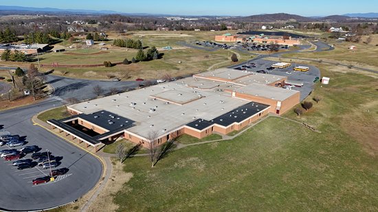
Stuarts Draft Middle School, where my sister and I both attended for sixth through eighth grade. My mother also taught here from 1997 to 2014. Two of my best years in school were here, as I consider sixth and eighth grade to be my top two. Both years were spectacular, with eighth grade’s being the best, and sixth grade’s being a very close second (seventh grade, meanwhile, was a disaster, and ranks near the bottom, surpassed only by fifth grade). Physically, Stuarts Draft Middle School was the first of the three middle schools that were built with this design, and the floor plan is reversed compared to the later Stewart and Beverley Manor buildings. It is also the only one of the three to have maroon-colored exterior doors (the others have blue doors), though these were brown when I attended. The school was enlarged in 1993 while I was in sixth grade, with a five-classroom addition built on the back side of the building, and a three-classroom addition built next to the bus loop.
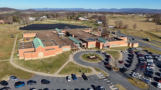
Stuarts Draft Elementary School. This school was built in 1995, replacing an older building on Draft Avenue (which itself is now Stump Elementary School). My sister attended this school for fifth grade in the 1995-1996 school year, and did second through fourth at the old building. I never attended Stuarts Draft Elementary, as I went to elementary school at Bonnie Grimes Elementary in Rogers, Arkansas.
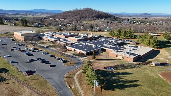
Stuarts Draft High School. My sister and I both attended this school for all four years of high school, with my attending in the late 1990s, while she attended in the early 2000s. The school was built in 1970, and renovated to its current form in the mid 2000s. The school was built at the same time as Wilson Memorial High School, and the two shared the same floor plan as originally built. Following the enlargement and renovations of both schools in the 2000s, Stuarts Draft is now marginally larger than Wilson.
That was the end of my school mission. I deliberately did not fly Buffalo Gap High School on this trip, because I had previously flown it in 2021, and it would have taken too much time to go out there and back along with everything else that I had planned for the day because it didn’t fit in a line with everything else. That school isn’t going anywhere, though, so I can always get newer photos of it with its brand new middle school wing at a later date. One thing that I appreciated about getting the aerial photos of the various schools was to see them in greater context. When you’re on the ground, you see them as these large, sprawling buildings, and you can’t really see the setting in which they sit very well. Go a few hundred feet up in the air, and the context becomes more apparent. Compare the photo of Stuarts Draft High School immediately above to this photo of Stuarts Draft High School that I took in November 2007. The more recent photo places the school with its surrounding area, with a rather imposing-looking hill about half a mile away, housing and farmland around it, and the mountains in the distance.
I also never realized how much Augusta County has invested in solar power. Of the four county high schools that I photographed on this adventure, all of them had solar power on their roofs to some extent or another, with the most extensive rooftop solar arrays at Stuarts Draft. Additionally, I also spotted solar panels at Stewart and Wilson Middle Schools, as well as at Riverheads Elementary, plus there was a pretty substantial solar farm behind Stuarts Draft Elementary. I wonder how much this offsets the county schools’ energy needs, and I wonder whether the school system is able to sell power back to the grid.
Another thing that I noticed when flying the high schools is that the parking lots were a lot less crowded than I would have expected, at all of the schools. Back when I was a student at Stuarts Draft, the parking lot would typically be full, and if you got to school late, you were parking in the overflow lot all the way over by the fieldhouse. These photos were all taken while school was in session, and the lots were all half empty. I caught Wilson Memorial High School right at dismissal time (note the buses in the shot), and the dismissal occurred while I was in the air. There was no congestion in the parking lot of any kind during dismissal. I remember at Stuarts Draft, I used to deliberately wait 20 minutes in order to allow the traffic to clear before leaving. Do older students just no longer drive themselves to school in the volumes that we did in the nineties, and rely more on the buses?
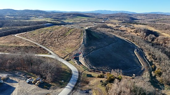
I took a lot more photos of everything that I flew than what I shared here, from lots of different angles, but we’ll save that for my Flickr. Since we had some time before Dad would come back from work, we went and did a few other things with the drone. First stop was the Augusta County Landfill, because why not. I remember going to the landfill as part of a field trip during a summer enrichment program in 1994, but I didn’t remember much about what it looked like, except for seeing stacks of old cars and appliances ready to be crushed and recycled for their metal content. I had also been over to the public disposal areas there a few times later in the 1990s, but they barely let you in past the entrance there, so not much to see. So I had never really gotten a good look at the landfill as something of an overview before, and now I was going to do it, pending my being able to locate a place to fly from, as the landfill is along a narrow road with very few places to pull off. Fortunately, I found a place to fly nearby, and up I went.
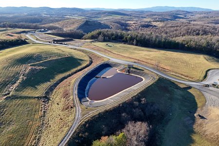
The Augusta County landfill, off of Christians Creek Road. I was surprised to not see any garbage anywhere. I expected to see big pits of garbage in the still-active landfill, but instead, I just saw a few green looking hills. I imagine that these hills have garbage inside them, but it’s completely covered. I flew all around, and it all looked neat as a pin.
Meanwhile, Mom was impressed by the way that I handled the drone here. The place that I found had tree branches directly above it, and she watched as I launched off of the roof of the HR-V, raised the altitude just enough to fly out of the little pocket that we were in, flew it out past the trees, and then ascended to cruising altitude. Likewise, she was impressed by the way that I brought the drone back to the home point, descended to a level beneath the trees, flew in, and then landed back on the roof of the HR-V before reaching out of the moon roof, pulling the drone back in, and placing it on the back seat.
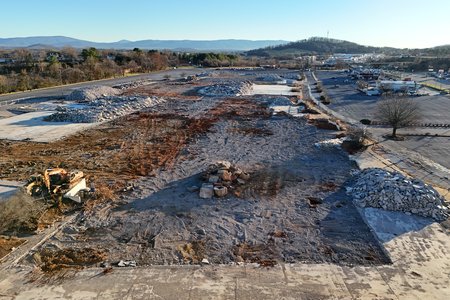
While we were out this way, we also checked out Staunton Mall. I had driven by it the night before, and had noticed that the Belk building’s south wall, which previously had been connected to the mall and was just bare cinderblock on my last visit, had been given a proper finish. Mom had also remarked that the mall property was “a mess”, so it was worth checking out. So I parked in my usual spot in the shopping center on the hill across the street, and sent the drone out to investigate.
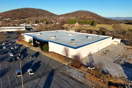
The Belk building at the former Staunton Mall, now with a finished south wall. The old mall entrance has been completely closed off, replaced by a simple emergency exit door.
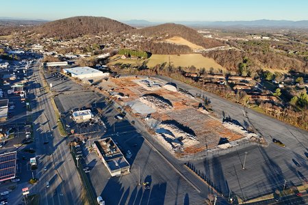
So apparently, work has resumed on the old Staunton Mall site after having stopped for about a year, as not only did they put a proper finish on the south side of Belk, but they are also now demolishing the mall’s slab foundation. It makes me glad that I did my walkthrough of the old mall when I did, because almost all of that is now gone. I suppose that we will find out soon enough if this is prep work ahead of whatever new retail/hotel/residential development is supposed to replace the mall, or simply a delayed completion of the demolition. After all, the mall has now been closed for three years, and most of the demolition wrapped up about a year ago. So this could signal the start of something new, or it’s just the final ending of something old.
And then this is what I spotted on the pavement a few spaces up from where Mom and I were sitting while I was preparing to land:

Yes, that is exactly what you think it is, just in case the description drawn next to it didn’t tip you off. Keep it classy, Staunton.
After that, Mom and I went back to the house, where Dad had just gotten in a few minutes before we did. Perfect timing. After we got in, we all went out for dinner, and then visited at the house for a while. Not a bad time. I left for home around 10:00.
On the way back, I stopped in at the post office to mail a Christmas card for Mom, which Woomy helped with:

Woomy mails a Christmas card at the Stuarts Draft post office. He didn’t like mailing the Christmas card, but Mom appreciated it all the same.
And then from there, I headed out. I usually make at least two stops on the way up, but this time, I ran it nonstop from Stuarts Draft to Haymarket, going up via Augusta Farms Road and Lifecore Drive, and then eventually I-81 to I-66. Then after a quick gas and bathroom stop, I did the last 50 miles to the house. All in all, not a bad trip. Next one of these is scheduled to occur in late March.
Categories: Augusta County, Charlottesville, Family, High school, Middle school, Staunton, Staunton Mall, Stuarts Draft, Travel, Waynesboro, Woomy


