


A fun and memorable day…
24 minute read
February 8, 2023, 9:00 AM
Today marks twenty years since I made one of my favorite early DC adventures. On that day, February 8, 2003, I drove up from Harrisonburg and headed up to the DC area on a Saturday for a day of fun, photographing the area in the snow and checking out parts of the Metro system that I’d never been to before. It was my senior year of college, and was one of three trips to DC that I made from my dorm that year. I also feel like I shot a number of my “classic” DC area photos on this trip, since a lot of photos from this trip have made their way all over the Internet (i.e. you’ve probably seen some of them in the wild, and never realized that they were my work).
This trip had an interesting set of circumstances that led up to it, though. As I recall, snow had been predicted for Thursday night and Friday morning. That prediction ultimately came to pass, as it snowed enough to cancel classes for Friday. This was not unanticipated, so, the night before, as part of my duties as a resident advisor in Potomac Hall, I had posted signs on my floor advising people to check the JMU website for information on class status. In other words, make sure that you have to go out before you go out, because you might not have to go out if the university cancels classes. The sign was posted with the intent of putting the responsibility for checking the status onto my residents, so that I would not have to get up early to check the status and post signs to that effect, since I didn’t have classes until later in the day, and would not wake up before the first classes of the day would have started. So with the signs posted, I went to bed. Good. Now fast forward to around 6 AM or so. I vaguely remembered hearing the phone ring a few times while I was trying to sleep, but I never answered it, because I was trying to sleep. Then I’m awakened by a very loud banging on my door. Having just been rudely awakened like that, my first response was to shout, “WHAT?!?” It was Mecca Marsh, our hall director, i.e. the boss, so it must be important. I went to get up, and in my haste in getting up, I lost my balance and fell back onto my bed, landing on my left elbow. When I landed, I heard a series of four or five popping sounds, and I remember thinking, “That can’t be good.” Apparently, that popping had come from something in my left shoulder, and it now hurt very much.
So what was the big, important reason that Mecca came up and woke me up out of a dead sleep? Make a sign and put it on the outside door stating that classes were cancelled. Believe me, she was lucky that my arm was sore from the injury that I had just suffered, because I probably would have hit her otherwise. I was absolutely seeing red following all of that. For the amount of effort that she went to, making multiple phone calls and then coming up to my floor and waking me up, just to order me to make a single sign, she could have done it herself. And when I mentioned that I had just injured my shoulder in the process of getting up, and that it now hurt very much, she responded with a dismissive, “You’ll be fine.” Yeah, way to show some compassion after an injury that you played a part in causing. I expected no less from Mecca, though, because she had her favorites on the staff and I was not one of them, and therefore I was treated accordingly. In any case, I made the sign, and tried to go back to sleep, but I was now pretty mad about what had just happened, plus I was in a good bit of pain. You understand why I consider Mecca Marsh to be one of the worst bosses that I’ve ever had. I probably should have seen a doctor on a worker’s comp claim, and I also can’t imagine that the management would have taken too kindly to the whole situation had I reported it like I probably should have, and it wouldn’t have reflected well on Mecca considering that she precipitated the whole thing. She would have hated that, considering how big she was on propping up her own image (she had some major inadequacy issues of her own). But I was only 21 and didn’t know any better, so I just suffered through it.
My mother and sister had been planning to come up later that day, and when they arrived and I told them what had happened to my shoulder, they were a bit more concerned about it than Mecca was. I never saw a doctor for it, though Mom did suggest that I put it in a sling to help it heal. I didn’t do that, mainly because it was my dominant hand that would be hung up, and I didn’t want that arm out of commission. So I just dealt with it, and fortunately, it healed up just fine on its own without any issues, but it hurt for weeks after that. We then went down to the house in Stuarts Draft so that I could retrieve the Previa (my parents did not allow me to keep the car on campus on a regular basis), and then I drove back to campus. After all, it made no sense to do the trip from Stuarts Draft, since (A) most of the stuff that I needed was in Harrisonburg, and (B) I would have had to pass right through Harrisonburg anyway to get to DC. Might as well just use the dorm, especially when, on previous trips when I did do it all the way from Stuarts Draft, I would dip into the dorm on the way back in order to offload the photos, and would fall asleep there anyway on account of being tired. Mecca tended to get hung up about RAs’ sleeping in the building when they had taken time off, but ultimately, it was none of her business, because we were paid a straight salary as RAs, and we still had to pay for our own housing and meal plan – thus the room itself was beyond the scope of her authority as hall director. Therefore, whether I remained in the space that I paid for while taking time off from the RA job was my business and only my business, no matter what Mecca Marsh might have thought about it. If the room was included as part of my overall compensation, that might have been a different matter, but it wasn’t, so therefore its use was my sole prerogative.
The next morning, I headed out. My camera at the time was Big Mavica, and I also brought along a tripod. This was a very early setup, as I did not have Big Mavica’s classic bag yet, and was carrying my equipment around in a Jansport backpack that my sister had previously used. I carried the tripod loose, because at that time, I had nothing else to put it in. My shoulder was still sore from the day before, so I did my best to subject that shoulder to a minimal amount of movement. Therefore, I typically held the tripod with that arm, which kept the shoulder fairly still. I would get the camera bag that I used with Big Mavica and its successors within the month, and I would get a tripod bag at Pentagon City Mall on the following trip to DC.
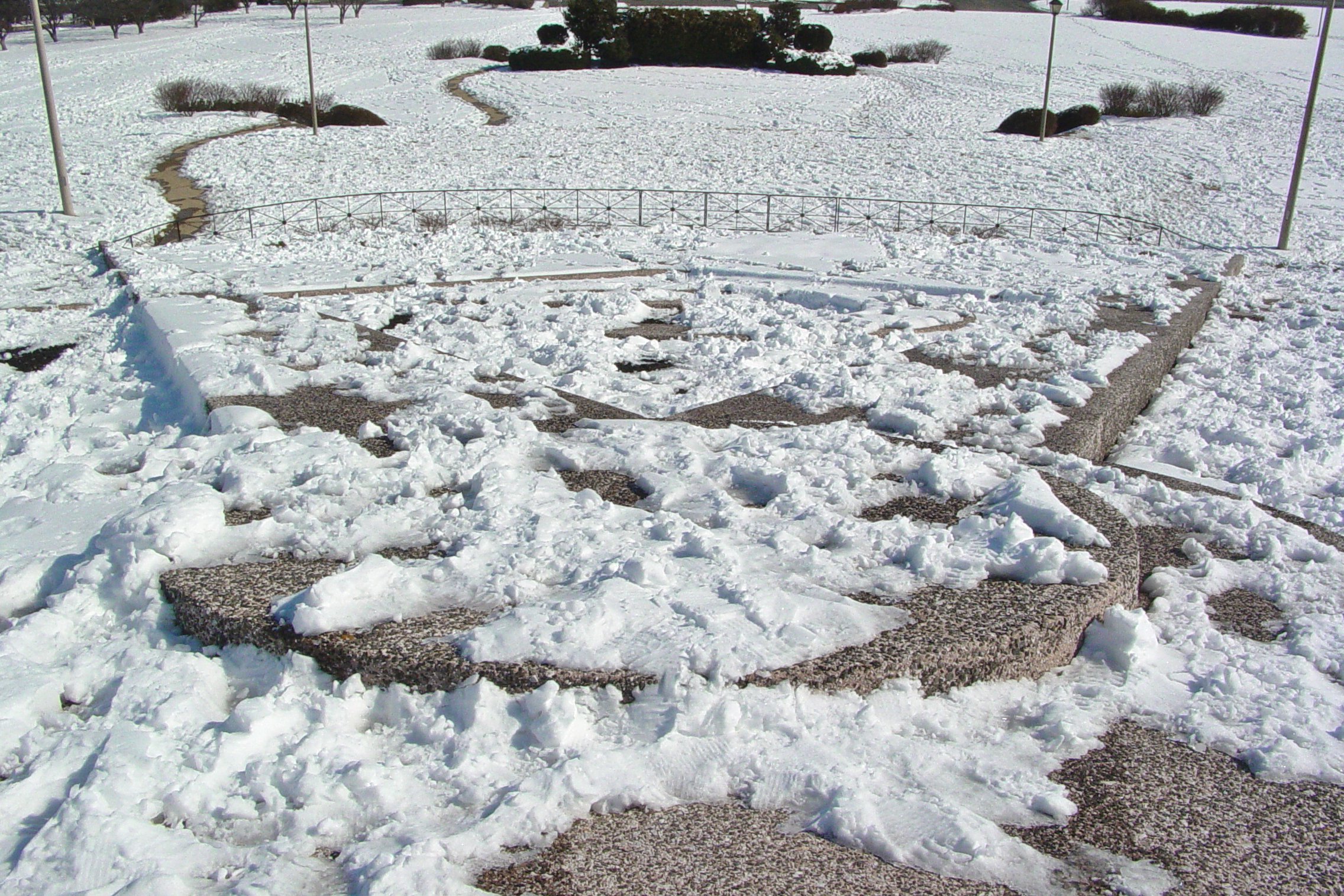
After hitting the road, my first stop was the New Market rest area on I-81 northbound. Clearly, I was in a photographing mood, because I photographed everything:

The main building at the rest area near New Market. I published this on Wikipedia a long time ago, and so it’s made its way around the Internet quite a bit.

Covered picnic table at the New Market rest area.

A bench.

Payphones at the New Market rest area.
It’s worth noting that every time I do one of these Journal entries where I revisit an old adventure, I’m always struck by how different the photography looks compared to what I’m used to. It’s a big reminder about how much my style has evolved over the years. This material looks like the work of a much younger man. Some of it is pretty good, while some of it leaves a bit to be desired, but it’s fun to revisit, and also to prep like it’s new material for these sorts of retrospectives.
Leaving the New Market rest area, I continued on, stopping again at the Manassas rest area, where I photographed some more:

Sign pertaining to pets at the rest area, which is pretty standard for Virginia rest areas. Note the double flag sticker.

Two tree trunks, with snow at their base.

Construction barrel.

Parking area at the Manassas rest area. This scene looks exactly the same today. The two Manassas rest areas are the smallest in the entire state.

I remember liking this photo a lot when I took it back in 2003, showing the sun shining through the trees. Now, in 2023, I can’t help but see all of the extra color around the sunlight that I would rather not have in there.

I believe that this dates this photo shoot quite a bit. That’s the Previa, which I drove from late 1997 to early 2006, parked at the Manassas rest area. The Previa will have been gone for 17 years this month. It still stands as the longest tenure of any vehicle that I’ve driven.
Leaving Manassas, I arrived at Vienna, where I boarded the Metro to head into the city. However, first, I photographed around the station a bit, taking my time going in:
 level at Vienna. I parked lower on this particular day because of the snow.")
 level at Vienna. I parked lower on this particular day because of the snow.")
Got some shots of the third level of the north garage at Vienna. This parking spot was unusual for me, because I usually tended to park on the topmost (fourth) level at Vienna. I parked lower on this particular day because of the snow.

A view across the highway to the south garage, which opened in 2001.

A view of Vienna station from the north garage, facing approximately east. I-66 certainly looks different nowadays, following an express lanes project in the late 2010s and early 2020s that widened the road and added toll lanes.

Icicles hanging from the edge of the north garage.

The Vienna north garage, viewed from the sidewalk. The Fairfax City CUE buses load from the bus stands shown here.

A Gillig Phantom services a stop on the CUE Green 2 route.

Vienna station entrance pylon.

Signage on the platform at Vienna, viewed from the escalator. I liked this version of the signage, because it explicitly indicated that trains to New Carrollton boarded from both tracks. This signage was replaced when a number of station names were updated in 2012, and there is now no sign at this location at all following the station’s renovation in 2020. I wish that this sort of wording would return, since my experience is that a lot of people get confused about where a train is going when it is boarding on the outbound track (to the right in this photo). I don’t know where they think that a train is going from there other than back to New Carrollton, because the tracks end just beyond the station.

My first train of the day, riding on car 1162.
My next stop was Rosslyn. There, I broke out the tripod and tested some long-exposure shots in the station.

A Blue Line train departs Rosslyn on the outbound track. At 21 years of age, I found it curious that the red streaks from the taillights were not straight. I know now that the train does bounce side to side a little bit as it moves, which accounts for the wiggly lines.

Long-exposure shot on the upper level, facing outbound. The wall is a bit blown out in this shot, but hey, I tried, and I was still relatively new at this stuff back then.
 certainly makes this shot look a little dated.")
Long-exposure shot on the upper level, facing inbound, with a train of Rohr cars at the platform. Having Rohrs in the lead and the train’s being centered on the platform (rather than all the way at the end) certainly makes this shot look a little dated. This photo has also made the rounds quite a bit, as I uploaded it to Wikipedia long ago.

One more long-exposure shot on the upper level, facing outbound. I like the star-shaped light from one of the pylons.
I liked these photos. At the time that I made these, I was not yet aware that there was a prohibition on the use of tripods in the system. I would learn that later on in the day. It’s hard to argue the rationale why tripods are not allowed, though, as relates to safety, with the thought’s being that tripods could be a tripping hazard.
Finishing up on the platform, I then went outside and photographed some of Rosslyn outside of the station:

The RCA Building as viewed from Rosslyn Center. This building is now being prepared for demolition, with equipment’s having been removed from the roof, and will ultimately be replaced by twin apartment towers.

This is Rosslyn Center, which is directly over the entrance to the Rosslyn Metro station. Rosslyn Center was renovated around 2020 or so, and now sports a gray facade, rather than the brown one shown here. I have yet to visit and photograph the renovated facility, though I imagine that it’s quite nice. Also, note the tree branches in front of the building. This was something that I did a lot in my college days. I thought it was artistic or something, showing a tree in the shot, or shooting through the tree or something, but the result was not so good. I have shot photos with trees in them with more success in more recent years, but what I did in 2003 is best described as “some effort was made” – but the results still sucked.

Skywalk over North Moore Street in Rosslyn. Nothing that you see in this photo still exists, save for the River Place North condominium tower, a sliver of which is visible in the upper right corner of the shot. Everything else that you see in this photo has been demolished.
I’ll be honest with you: it’s weird seeing these photos of Rosslyn. So much has changed with Rosslyn in the intervening two decades, possibly to the point that someone who only recently became familiar with Rosslyn probably wouldn’t recognize these photos as being of Rosslyn.
Then I boarded the Metro again, and headed over to McPherson Square station. When I put out some feelers about what I should photograph in DC, a friend of mine suggested that I photograph the White House. I thought that was a great idea, because I had not done the White House since I’d gotten Big Mavica, so this seemed like a good opportunity to give it a spin, and in the snow, no less.

Coming up the escalator at McPherson Square on the Vermont Avenue side.

The Export-Import Bank of the United States.

Street signs at the intersection of Madison Place NW and H Street NW, at the northeast corner of Lafayette Square. I do not know why there is tape on the H Street sign.

A pigeon. What does it say that my first thought upon seeing this photo was that this bird has probably been dead for over 15 years by now?

SunTrust building. This is one of my favorite buildings to photograph in the area around the White House.

This is one of the photos from the White House set. I’m not going to rehash the photo set here, because you can find it right here, plus none of those photos are particularly good (“polishing a turd” came to mind). This was full of examples of trees in front of the intended subject, and thinking that it looks artsy. I admit, though, that I probably could have done better with a bigger zoom lens. But this was the Big Mavica era, and Big Mavica only had 3x optical zoom, with no option for changing lenses. Sure, it had digital zoom, but I never found the results of Big Mavica’s digital zoom to be particularly pleasing, so I usually had the functionality disabled.

This sign in front of the Old Executive Office Building is about the only photo from the White House photo shoot that I found to be of any redeeming value upon reviewing these photos in the here and now, and I had never run it before. So here it is.

This is another photo from the White House set. I just want to draw your attention to Pennsylvania Avenue. Here, it still looks like a street. Pennsylvania Avenue in front of the White House was a regular street until the mid nineties, when it was closed to traffic, blocked off by Jersey barriers. Then in 2004, it was given security upgrades and turned into a pedestrian area.

Steam coming up from the street near the intersection of 17th and G Streets NW.

And back to McPherson Square station.

And my train arrives at McPherson Square – all Rohrs. I used flash for this photo, doing what I consider untoward nowadays. Generally speaking, don’t flash your flash in front of an oncoming train like I did here. We don’t want to distract the operator.
Back on the Metro, I headed to Alexandria. I was planning on visiting the George Washington Masonic National Memorial to get a tower tour in order to photograph it again now that I had Big Mavica, following a visit in late September 2002 with the original Mavica. Those photos with the original Mavica were a bit lacking in quality, and not all of it was related to my skill level at that time. Rather, I had done as much as I could do with that older camera, and it was time to upgrade. So I took the train down to King Street, and started heading over to the Masonic Memorial.

The Masonic Memorial. This photo would be perfect if not for that pedestrian signal in the bottom of the shot. Wishing I could go back in time and tell past me to take a few steps forward in order to get that thing out of frame.

Alexandria as viewed from the grounds of the Masonic Memorial.
The Masonic emblem, covered in snow.
Then when I got to the top of the steps, I discovered that the memorial was closed (probably because of the snow). I was not happy about that, considering how treacherous the climb was up those snow-covered stairs to get there. But at the same time, what are you going to do, I suppose. So with nothing else that I could do, I headed back down, though on a less-treacherous route than I had taken going up. Because this was a bust, I ended up moving the Masonic Memorial visit to my next planned DC adventure in March. That visit definitely bore fruit, since it produced a very popular photo of Old Town that I took from the top of the Memorial.

A side view of the Masonic Memorial taken on the way back down. And again with the trees in front of the subject.

“SIGNAL AHEAD” sign, with “RED” in LEDs for when the light was red. I would come back to this sign on a later visit to photograph it at night with “RED” illuminated.
So the Masonic Memorial was a bust, but, you know, these things happen. So I got back on the train and rode up to Crystal City for a bit.

This was not my first time in the Crystal City Underground, but I always enjoyed the fire alarm system down there. The Crystal City Underground was the first time that I had ever seen the older style of the Edwards pull stations, and discovered that not only was the wording different, but they were also much larger than the classic Edwards pull station that I was otherwise accustomed to. This was my first time photographing these pull stations with Big Mavica, replacing earlier low-resolution photos that I had taken with the original Mavica.

The notification appliances in the Crystal City Underground at this time were these Edwards 324 fire bells.
 pull stations.")
Other parts of the Crystal City Underground had Gamewell Century (“full moon”) pull stations.
I’m glad that I got these photos when I did, because this system had been replaced with a more modern system by late 2008. It made me sad to see new alarms in there, but I get it.
Then I went outside for a bit.

Station entrance pylon for Crystal City.

1960s-era office buildings in Crystal City. Back then, the buildings in Crystal City had names, but they were renamed in 2004 in order to reflect more modern urban design philosophies in a remarketing of Crystal City, with their new names reflecting their new street addresses. Shown here, left to right, are Crystal Mall 2 (now 1801 South Bell Street), Crystal Mall 4 (now 1901 South Bell Street), and Crystal Mall 1 (now 1800 South Bell Street).

Crystal Place, an apartment building nearby. This building still uses its original name, likely because, unlike commercial buildings, residential buildings tend to have names.


I made some use out of the tripod that I’d been carrying around all day, setting it up in Crystal City and taking some selfies. See, kids, this is how we did selfies before we had camera phones.
For some reason, I also considered it important to stop here and narrate my adventure a little bit while I already had the tripod set up. So, to that end, I shot two short videos where I explain what is going on in my day. I now consider this to have been completely unnecessary, especially when this day was ultimately presented as several focused photo sets and various transit photos, and not holistically. But nonetheless, here are my goofy little videos:
So much cringe here. But I was 21 and didn’t know any better.
I also came back with a bunch of short five-second videos consisting of annotations for a number of the photos (example). Basically, being less familiar with the area back then, and before the advent of geotagged photos and Google Street View, I baked my reference material right into the shoot. I still do this to an extent today, but nowadays, it’s mainly to get a geotag on a specific location. Thus I’ll shoot a bunch of material with my real camera, then get a couple of throwaway shots with my phone for the GPS features. The somewhat more crude methods that I used back then did what I needed them to do, but I definitely appreciate the more modern tools available today.
And then I went back into the Metro and continued on, heading up to L’Enfant Plaza, where I photographed some Metro trains.

A Breda car leads a Green Line train traveling towards Greenbelt arrives at L’Enfant Plaza. Again with the flash in front of an oncoming train. Meanwhile, this would be a decent photo, except for that dust particle that my flash illuminated near the middle of the shot.

I broke out the tripod again in the station mezzanine, getting a photo of the upper level of L’Enfant Plaza station.


These are a couple of random shots that I took using the tripod of the mezzanine on the Maryland Avenue side at L’Enfant Plaza.

Escalators at the Maryland Avenue entrance of L’Enfant Plaza station.

L’Enfant Plaza station entrance pylon. Note the lack of a green stripe.
I then got back on the train and headed up to Gallery Place-Chinatown station:

The big Chinatown fan at the 7th and F entrance, viewed from the mezzanine above, taken using the tripod.
Not long after this, as I closed in on the fan for a better look, I was informed about tripod usage, i.e. take all of the photos you want, but no tripods for safety reasons. I was disappointed, but fair enough. From here, I had planned to transfer to the Red Line anyway to head over to Union Station, so I continued on my way.
At Union Station, I was there to photograph the place, up to then sight unseen. I wandered around the place and photographed what I saw. I ultimately created a photo set about the visit, though I consider the photo set to be grossly inadequate compared to what I might do today. Like the White House set, I’m not going to rehash the photo set here, because you can find it right here if you really want to see it. Most of the photos weren’t very good, but there are a few things worth pointing out that I caught there on this day.

I never ran this photo as part of the set, but I kind of like the way that I framed the various light fixtures on the station.

Sign for the AMC movie theater that was in the basement of Union Station. The theater is long gone, having closed in 2009, and was replaced by a Walgreens and a Wendy’s.

Another shot that I didn’t use, looking somewhat upward in the shopping mall portion of the facility. It’s been a few years since I was last here, but my understanding from a video taken in the last few years is that this is all pretty much dead now.

The basement food court at Union Station in its original form. I was kicking myself later for not exploring the basement of the building at all in this set, especially after the food court was remodeled a year or so after I took these shots. The remodeled version of the food court, which took on a white color scheme, is the one that I remember most. I miss that version, too, since it had mostly independent vendors serving up food there. The 2010s saw those independent vendors’ getting pushed out in favor of chain restaurants, and it just wasn’t the same anymore.

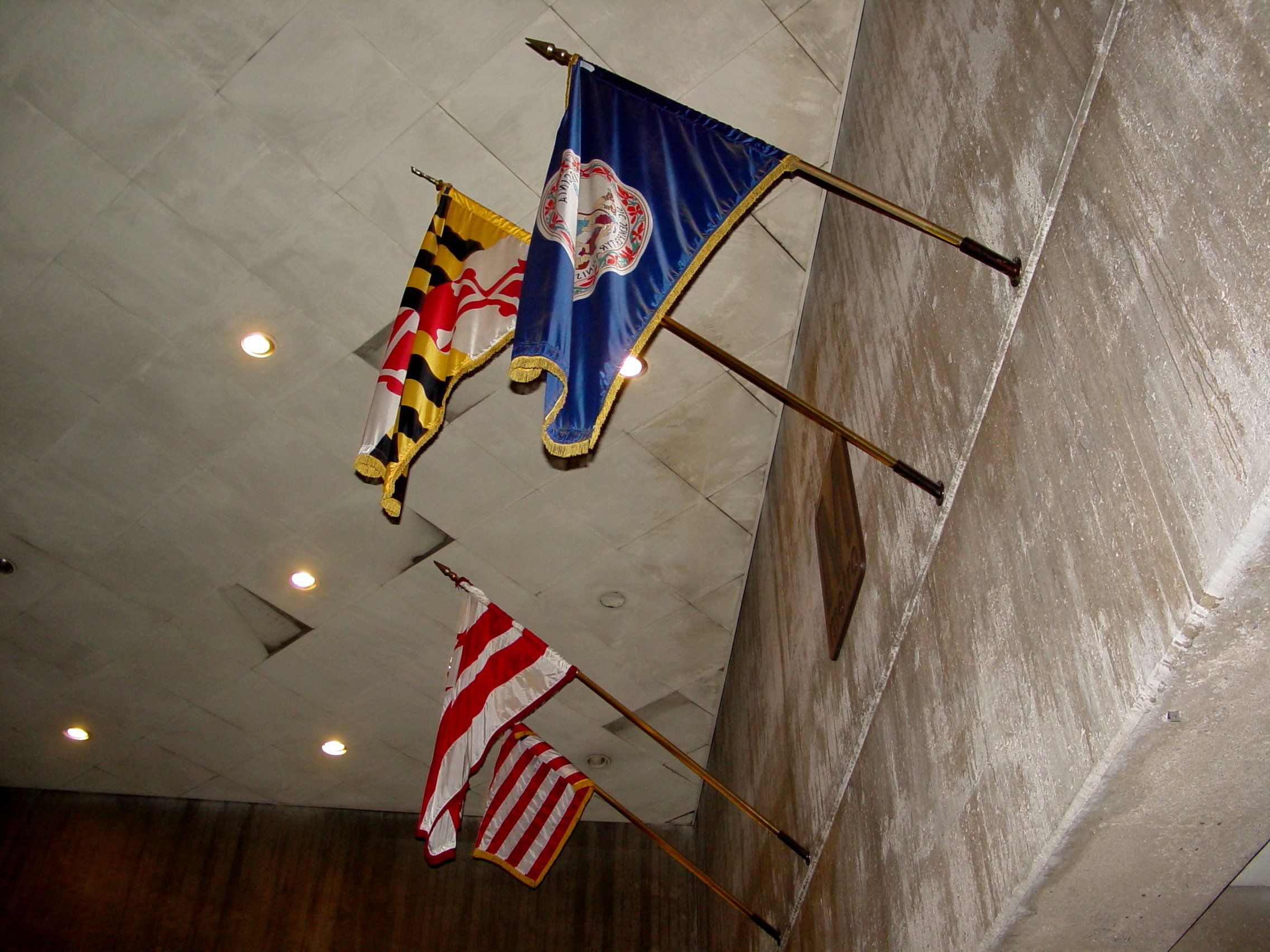
Alternate shot of the flags over the entrance to the Metro station. It’s still not a great shot, but it’s better than the one that I did use.
Finishing up at Union Station, I headed into the Metro. Seeing daylight down the tunnel beyond Union Station, I boarded a train towards Glenmont just to see what was out there. I soon found myself above ground, going past Metro’s Brentwood rail facility, and then eventually at Rhode Island Avenue station, where I exited the train. I suppose that I figured that I had gone far enough. I never left the station platform, but I did manage to check out some new territory, and shot some photos in, of, and from the station. This is an area that has changed significantly over the last two decades, and these views are very different nowadays.

So much about this photo is different. The station is still the same, but that’s about it. The train has been rehabilitated, and the warehouse visible to the right of the train is now luxury apartments.

This view is now almost completely different, as much of the old Rhode Island Avenue Center shopping center has been redeveloped, and the property is now known as Bryant Street. All of the buildings to the right of the Safeway have been demolished, and the remainder have been repurposed.

Thie view is no longer possible, as a mixed-use residential and retail development called Rhode Island Row was built on what was previously a Metro parking facility.

This is another view that has changed. The station is the same, the Capitol is still the same, but there are a lot of new high-rise buildings between here and there, as a large building boom has occurred in this area, with a lot of luxury apartment buildings’ having been built in the last ten years.

And back on the train. Time to head to my next destination!
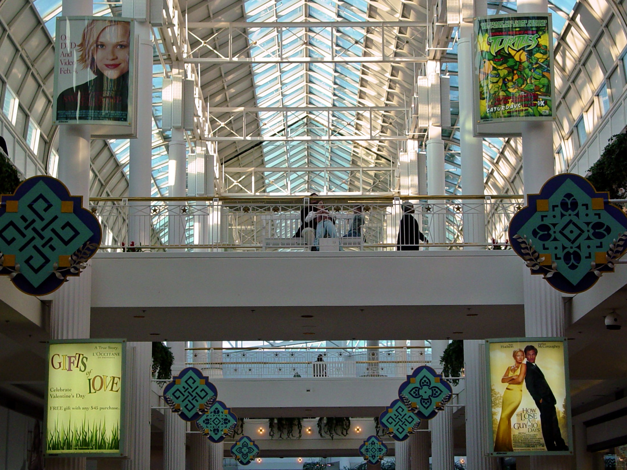
My next stop was Pentagon City. When I would do these DC trips before I moved up here in 2007, a visit to Pentagon City Mall was a regular occurrence. If it tells you anything, I could probably count on one hand the number of DC trips that I made between 2003 and 2007 that did not involve a stop at Pentagon City Mall. The visit to Pentagon City usually signaled that the “official” part of the trip was over, and that it was time to change gears and have a little rest and relaxation before heading home. In this instance, however, the photography continued.

Washington Tower, the office building over the front part of Pentagon City Mall, photographed from across the street. The mall carried this building’s architectural style into the interior of the facility, with rooftop dome’s appearing in other places throughout.

This is my classic Pentagon City photo, which I took while sitting on a bench on the topmost level of the mall. I uploaded it to Wikimedia Commons back in 2005, and it’s made the rounds on the Internet for many years since. It always amuses me, though, when people mistakenly identify it as the Mall of America, which is a much larger shopping mall in Bloomington, Minnesota. Meanwhile, referring to this view specifically, things look very different following a renovation of the mall in 2014. Along with an overall darker aesthetic, a new bank of elevators was constructed forward of the single elevator that is visible here, and new escalators were built to replace the originals.

The glass roof of Pentagon City Mall.
The Nordstrom wing at Pentagon City Mall.
I then headed next door to Pentagon Row, and started photographing with my tripod. I’m pretty sure that I did this so that I wouldn’t have to carry it around for a while, but at least I got something (sorta) useful out of the effort:

The center court at Pentagon Row.

Starbucks Coffee.

Thaiphoon restaurant.

Bally Total Fitness. This later became LA Fitness along with all of the other Bally locations in the area.

Lebanese Taverna restaurant.
In looking at these photos nowadays, it strikes me how different Pentagon Row looks these days. For one thing, it’s not called Pentagon Row anymore. Now, it’s called “Westpost at National Landing”, following a renaming in late 2020. Beyond the new name, though, except for Lebanese Taverna, practically every single business that you see in these photos is gone, and a different business now occupies the space. Among other things, the former gym is now an office.
I also photographed the ice rink for the first time on this visit:

Resurfacing the ice.

One of the skate guards takes the resurfaced ice for a quick spin before inviting the public back into the rink.
Apparently, the Pentagon Row part of the trip stuck out the most for me, because when I put these photos into a folder, I called it “Pentagon Row”. That name for this day’s shoot is entrenched enough in my head that when I started writing this Journal entry, I almost instinctively titled the files for the website with the prefix “pentagon-row”.
Finishing up at Pentagon Row, I did one more little bit of photography, going up to Smithsonian station and photographing the Washington Monument and the Capitol in long exposure from approximately 12th Street:


Yeah, I think that these could be characterized as “efforts were made”, but the results were less than satisfying. I think that at this point, I had finally run out of steam, and it affected my photography, even with the lower standards that I had back then. This felt like one stop too many, and the results reflected that.
From here, I got back on the train, and headed back to Vienna. At that point, it was starting to get late, and I had been running around since very early in the morning. It was time to pack it in. Getting to Vienna, I then drove back to my dorm in Harrisonburg, and then brought the car back to my parents the next day. All told, I shot a total of 710 photos on this day. That was my single-day record for a very long time, well past the end of the Big Mavica era.
I think that I enjoy looking back at this day so much because it represents a time when I was exploring a new area and expanding my horizons. I went to places that I had been before, and I also went to new places. I also got to experience my first snowy day in the region. It’s so weird to see this sort of stuff because it’s the area that I know very well now, from a time when I didn’t know it nearly as well as I do now. It was also a time when I was too timid to drive any closer to Washington than the nearest Metro station. Compare to now, where I’ll drive anywhere in the region. Sort of an air of innocence back then, I suppose? In any event, I hope you enjoyed this discussion of a fun day. These early trips didn’t really get much coverage on their own merits (even if you’ve seen materials from those days before) because these trips predated the Journal, and the old quote article format didn’t really work for that sort of discussion.
Categories: Alexandria, Arlington, DC trips, JMU, Northern Virginia, Personal health, Washington DC