


The taming of the stroad?
15 minute read
December 1, 2022, 10:00 AM
About three weeks after the accident that claimed my HR-V, I read on The MoCo Show about another accident that occurred on the same stretch of road at Russell Avenue, a block away from where my accident happened, that looked very similar to mine. Additionally, I remember an accident that occurred at the same intersection as mine in May 2020 that Elyse and I encountered while we were out and called in to 911. Taken together, it tells me that Montgomery Village Avenue (MD 124) between Interstate 270 and Midcounty Highway is a poorly designed road that probably needs to be rethought and redesigned in order to increase safety along that stretch.
For those not familiar, Montgomery Village Avenue, along with quite a number of other roads in Montgomery County, is what is often referred to as a “stroad“. Wikipedia defines a stroad as “a type of thoroughfare that is a mix between a street and a road”, and the word itself is a combination of the words “street” and “road”. Basically, it’s a road that wants to function as a local city street and as a major highway all at once, and often fails at both roles. These roads are typically designed for relatively high speeds, but their functioning as a city street with pedestrians and so many private accesses means that the posted speed limits are typically well below the road’s design speed. Do you remember that Journal entry that I wrote in 2013 about people who were getting run over at bus stops in Montgomery County? All of the streets in question were stroads. Georgia Avenue in particular is the textbook definition of a stroad, being a six-lane divided highway with private access, including single-family residential, directly off of the main road from Silver Spring to all the way to Olney. The speed limit for much of that road is 35 mph from Silver Spring to Leisure World, with a posted speed of 25 mph through Wheaton. I speak from experience from ten years’ time living just off of Georgia Avenue that it is very difficult to maintain that speed limit when traffic is moving well, and I often found myself exceeding the speed limit without realizing it and then having to slow down once I do notice. That’s because the road is designed for much higher speeds than traffic is actually allowed to go, and people tend to drive in a way that befits the road design, especially during off hours. They say that if you can speed on a road and not realize it, and not feel that your higher-than-allowed speed is actually dangerous, then the speed limit is too low for the design of the road. In other words, the usual go-to argument of, “LoWeR aLl ThE sPeEd LiMiTs!” is a major non-starter for me, if because the speed limit was already too low for the design of the road, and people weren’t following it anyway, what’s the point of lowering it further? They weren’t following it when it was 35, so what makes you think that they’re going to follow it at 25? I also find the way that people are so quick to blame drivers 100% for accidents to be problematic, because the design of the road can also be a legitimate contributing factor to accidents, such as roads that are designed for much higher speeds than anyone probably ought to drive. It’s kind of like how the “no u-turn” sign is often a symptom of poor road design, because with a better-designed road, you wouldn’t need signage that disallows obvious and mostly reasonable moves to get around the poor road design.
In the case of Montgomery Village Avenue, so many accidents along that stretch of road tells me that as far as another accident goes, it’s not a matter of if another accident will occur, but when another accident will occur, especially at night. During the daytime, that road is a fairly congested place, with everyone’s trying to get through a series of signalized intersections. As a result, no one is moving very quickly, and there are turn restrictions in various locations in a ham-handed attempt to mitigate the problems with this disaster of a road. If it tells you anything, when I was commuting to a work location in Falls Church, Virginia every day, Google wanted me to go through that section of road to get to 270. Elyse and I drove the route as Google recommended on a dry run one day before I started over there, and after one time dealing with that mess – during midday, no less – I said that I wasn’t going to deal with that every day, because I didn’t want the frustration. So I ended up going a more southerly route, joining 270 at Shady Grove Road, which is a little bit further south, and way less frustrating of a drive. At night, the road is far less congested, and as such, it’s a more reasonable route during those hours, and thus I would often take it when going home. I believe that this route gets so congested during the day because it’s closest access to 270 for a large area, including almost all of Montgomery Village. Google always suggests going this way when giving me directions to 270, for one.
Then during the overnight hours, between 12:30 AM and 5:30 AM, many traffic lights in the county switch to flash mode. This includes the intersections with I-270, and Christopher Avenue/Lost Knife Road, and Midcounty Highway. The intersections with Russell Avenue and with Frederick Road (MD 355) remain in normal operation all night. In both of those cases, Montgomery Village Avenue gets the flashing yellow, while Midcounty Highway and Christopher Avenue/Lost Knife Road get the flashing red. The 2020 accident at Christopher/Lost Knife occurred just after 12:30 AM, and my accident occurred just after 2:00 AM, i.e. while the lights were in flash mode, essentially giving stop signs to the side roads. The Russell Avenue accident occurred around 10:15 PM, but that’s less relevant because that intersection doesn’t change to flash mode.
As far as the accidents went, it was pretty easy to piece together which vehicles were the striking vehicles and which ones were the struck vehicles in each instance based on the damage, however, I can only tell you the sequence of events for the accident that I was involved in, as I didn’t witness the 2020 accident as it happened (we encountered it not long after it happened), and the news article about the accident on Russell Avenue didn’t specify how it happened – it only showed the end result.
In any event, I knew that I wanted to look into things along this stretch of road in some more detail. So I went out one afternoon and fired up the drone, and photographed the various intersections in this area in order to get a better idea of what we’re dealing with.
First, the intersection between Montgomery Village Avenue and Midcounty Highway:

Overhead view of the Montgomery Village Avenue and Midcounty Highway intersection. North is to the right in this photo. The road coming up from the bottom is Midcounty Highway, which ends at this intersection, while Montgomery Village Avenue is running left to right. The route 124 designation comes in from the left, and then turns east to follow Midcounty Highway for about 1.6 miles before turning again onto Woodfield Road. The signals at this intersection are in flash mode overnight.

The intersection as viewed from the approach on Midcounty Highway. Note three left turn lanes and two right turn lanes here. Both right turn lanes have a no-turn-on-red restriction.

View of the Midcounty intersection, facing approximately east. The northbound lanes of Montgomery Village Avenue are visible along the bottom of the shot (southbound is out of frame), and Midcounty Highway runs top to bottom.

View facing northbound on Montgomery Village Avenue.

View facing southbound on Montgomery Village Avenue.
This is the intersection between Montgomery Village Avenue and Christopher Avenue/Lost Knife Road:

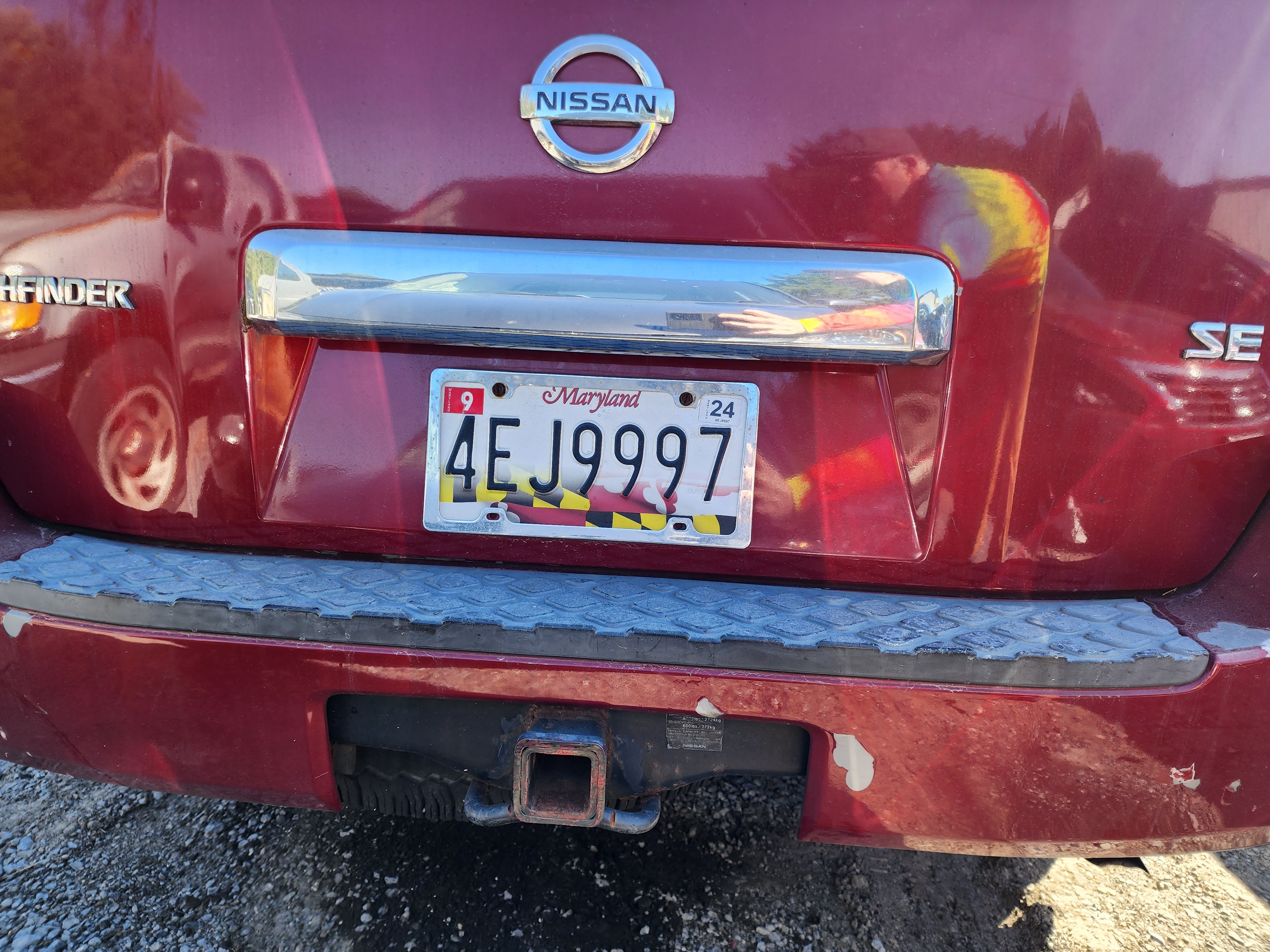
Overhead view of the intersection between Montgomery Village Avenue and Christopher/Lost Knife. In this photo, Montgomery Village Avenue is running top to bottom, with northeast at the top of the photo. Christopher Avenue is in the left half of the photo, and Lost Knife Road is to the right. This is the intersection where my accident occurred. I was traveling from the bottom to the top on Montgomery Village Avenue with a flashing yellow light, while the red Pathfinder was traveling left to right at high speed and ran the flashing red signal. That car spun around and ended up in the left turn lane on Lost Knife, facing the intersection, while my car traveled 150 feet down westbound Lost Knife (i.e. the wrong way) and came to rest at the curb.

This is facing the same direction as the previous photo, but back a bit and from a lower angle.

View from roughly above Gaithersburg Library, with Montgomery Village Avenue’s running left to right, Lost Knife Road’s coming down from the top of the photo, and Christopher Avenue’s coming up from the bottom.
Here’s the intersection of Montgomery Village Avenue and Russell Avenue:

Overhead view of Montgomery Village Avenue and Russell Avenue. Northeast is at the top of the photo. Montgomery Village Avenue runs top to bottom, and Russell Avenue runs left to right. A fire station has its own access to the intersection, which I suspect is the reason that Russell Avenue’s signals do not change to flashing overnight.

View facing north. Montgomery Village Avenue runs bottom left to top right, and Russell Avenue runs top left to bottom right.

View facing northeast, from a lower angle and further back than the first photo.

View facing southwest, looking toward Frederick Road.

View facing southeast, from the perspective of traffic traveling southbound on Russell Avenue.

View facing northwest, from the perspective of traffic traveling northbound on Russell Avenue.
This is the intersection between Montgomery Village Avenue and Frederick Road:

Intersection between Montgomery Village Avenue and Frederick Road. Northwest is at the top of the photo. Montgomery Village Avenue runs left to right with northbound traveling to the right, while Frederick Road runs top to bottom with northbound traveling towards the top. This intersection also does not flash overnight.

View facing southwest, from the perspective of southbound traffic on Montgomery Village Avenue. Note that there are both left and u-turn prohibitions for Montgomery Village Avenue traffic at this intersection. Traffic going to southbound Frederick Road is directed onto Russell Avenue and then onto Lakeforest Boulevard in order to make their left turn. Remember what I said about those “no u-turn” signs’ being a symptom of poor road design? There you have it.

View facing northwest, from the perspective of traffic traveling northbound on Montgomery Village Avenue. Note that Montgomery Village Avenue south of Frederick Road is eleven lanes wide at this point: one southbound lane that turns out to northbound 270 that is denoted by a dotted line, three southbound travel lanes, two left-turn lanes from northbound Montgomery Village Avenue to northbound Frederick Road, four northbound travel lanes, and then one lane denoted by a dotted line and then a solid line that turns out to southbound Frederick Road.

View facing southeast, from the perspective of southbound Frederick Road.

View facing northwest, from the perspective of northbound Frederick Road.

View facing northeast, from the perspective of northbound Montgomery Village Avenue, with all eleven lanes in all of their glory.
And finally, this is the interchange between Interstate 270 and Montgomery Village Avenue:

View facing approximately north, showing the interchange between Interstate 270 and Montgomery Village Avenue, which becomes Quince Orchard Road south of this interchange. Northbound traffic on 270 is traveling right to left. This is a partial cloverleaf interchange, with a signalized intersection for traffic coming off of southbound 270, traffic from northbound Quince Orchard Road going to soundbound 270, and traffic moving in and out of the park and ride. In addition, the merge between the ramp from northbound 270 and northbound Montgomery Village Avenue is also signalized.

Detail of the signalized merge between the 270 ramp and northbound Montgomery Village Avenue. View facing northbound. This intersection goes into flash mode overnight.
My first reaction when thinking about how to improve Montgomery Village Avenue, at least as far as my accident was concerned, was a desire to eliminate the flashing mode during overnight hours at the Christopher/Lost Knife intersection, and have it function as a standard traffic signal all night long. But then upon further consideration, I determined that would be unproductive. The way that my thinking went was that if the driver of the Pathfinder was already driving with flagrant disregard for the traffic signals, what reason do I have to think that they would do any better job at observing the signals if I had a green light rather than a flashing yellow, and they had a solid red signal rather than a flashing red? I soon realized that the answer was none at all, and therefore I reasonably concluded that the same result would likely occur. I also concluded that installing red light cameras wouldn’t do anything to prevent the collision. All that enforcement cameras are is a tacit admission by the jurisdiction that they know that a problem exists in a given location, and are either unable or unwilling to fix the problem, and so, failing to actually make the roads safer, they have instead chosen to simply exploit the problem for money and collect that sweet, sweet fine revenue. So with a red light camera in place, the accident would still have happened, and two cars would still be totaled, but the red Nissan Pathfinder with license plate number 4EJ9997 would also get a ticket for $75 on top of whatever else. Whoopty-doo. That doesn’t do a single thing to help keep me safe. I also couldn’t think of any physical changes to the roadways for purposes of traffic calming that could be accomplished with relative ease and actually be effective.
Considering the accidents at night when the road is not busy, as well as the general difficulty of getting through the area under normal conditions during the day, my mind eventually went to a somewhat more radical approach to improving Montgomery Village Avenue: sink it. In other words, drop the level of the road down below the grade of the surrounding streets and separate through traffic from local traffic. Montgomery County has already done this for problematic at-grade intersections in other locations, turning them into something more interchange-like. Randolph Road at Georgia Avenue was a problematic intersection of two stroads, and then they lowered Randolph Road to create a tunnel under Georgia Avenue for through traffic, and turned the outermost lanes into ramps for traffic turning onto Georgia Avenue. Here’s what it looks like, as seen on Google Maps:
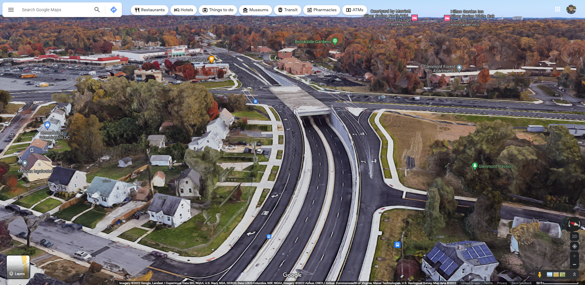
Aerial view of the improved intersection from the perspective of Randolph Road, facing eastbound.

Aerial view of the improved intersection from the perspective of Georgia Avenue, facing southbound.

Beginning of the improved section on the west side of the intersection, facing eastbound. Access to existing houses was accomplished via the ramps, and access to side roads was also accomplished via the ramps.

Approach to the tunnel on the west side, facing eastbound.

Beginning of the improved section on the east side of the intersection, facing westbound.

The only turn restrictions in the whole project area were on the east end of the project for eastbound traffic. Traffic coming out of the tunnel was not allowed to cross the local lane to turn right onto Glenmont Circle, and traffic in the local lane was not able to make any turns. Any turns from the local lanes were accomplished from Glenmont Circle, which was accessed by a classic New Jersey-style jughandle.

Perspective from southbound Georgia Avenue.

Perspective from northbound Georgia Avenue.
I’m proposing something similar for Montgomery Village Avenue, but on a larger scale. Rather than digging out one intersection, I propose digging out three: Frederick Road, Russell Avenue, and Christopher Avenue/Lost Knife Road. Run two lanes of Montgomery Village Avenue unimpeded in both directions from just south of Midcounty Highway to just south of Frederick Road, near Sam’s Club. That would address the through traffic and get them through the area without having to wait at multiple lights and contend with cross traffic. Local traffic, i.e. traffic that is going to interact with Christopher Avenue/Lost Knife Road or Russell Avenue, goes up, while through traffic that’s going to 270, Frederick Road, or into Montgomery Village goes down. I would place an interchange at Frederick Road, with the local lanes and ramps’ interacting with Frederick Road via a SPUI (here’s even more information about SPUIs). Meanwhile, there I would propose not having separate access from the through lanes for Christopher/Lost Knife and Russell, and instead just bridging over the through lanes, and treat each of these crossings as a single intersection, i.e. similar to a SPUI but technically not a SPUI. I don’t propose also rebuilding the intersection with Midcounty Highway because that intersection is pivotal for some changes to the roads that I believe would necessitate keeping that intersection at-grade, despite how much I don’t like making certain movements through that intersection, especially through that triple left turn lane. At the intersection with Midcounty Highway, the MD 124 designation leaves Montgomery Village Avenue and turns to go down Midcounty Highway. Additionally, Montgomery Village Avenue changes a bit after Midcounty Highway, becoming a county road rather than a state road, and it takes on a more residential character and becomes less busy overall as it heads into the heart of Montgomery Village.
As far as building it goes, I believe that there would be enough space to build what I’m proposing without sacrificing too much as far as structures go. Much of the area in question runs along the northwest side of the Lakeforest Mall property, with two manmade retention ponds and parking lots immediately adjacent to the road. If one needed to acquire additional land through eminent domain, that would likely be the place to do it, sparing several businesses on the other side of the road. The only major “pinch points” that I can envision would be at the ends of the area, with residential development on both sides of Montgomery Village Avenue just south of Midcounty Highway, and a Sam’s Club and new industrial development at the intersection with Frederick Road, with the Sam’s Club’s being particularly close to the road. I imagine that in the case of the spot near Midcounty Highway, one could take away some open land near the road, bringing the road closer to the existing developments, and still be okay. At Frederick Road on the Sam’s Club side, I think that most improvements could probably be accomplished within the road’s existing footprint, considering that Montgomery Village Avenue balloons out to eleven lanes at that intersection.
But the tragedy of all of this is that it’s very unlikely that this stretch of road will ever be improved and made safer for the foreseeable future, and therefore accidents will continue to occur. I suspect that it would be considered to be both too expensive and too disruptive, along with the space concerns that I mentioned earlier. Additionally, I feel like Gaithersburg doesn’t really have the people to advocate for it like they do downcounty, so it would generally be a harder sell compared to further south in the county where there tends to be more influence. Plus, too often, road projects are pitted against transit projects with one “winning” and one “losing”, when the two really should be seen as going hand in hand. After all, in an area like Gaithersburg with no Metro service (and no real plans to expand the Red Line beyond its current terminus to Gaithersburg) and only a single commuter rail line, transit in upper county is all about buses. And buses need good, safe roads to operate on just as much as cars do. Therefore if you make good roads, you also get better transit – a win-win for all. Unfortunately, however, too many people take this “cars are bad” mindset to the extreme when it comes to advocating for transit, where, if it’s possible that a project will benefit a car driver in any way, certain people will be against it, even if a project would also benefit the transit services that these same people so fiercely advocate for. It’s frustrating, to say the least.
In the meantime, keep your head on a swivel all the time, because these roads are dangerous because of poor design, being designed for speeds much higher than would ever be advisable based on the settings that they’re in. And unfortunately, too many people don’t realize how bad our roads really are, and therefore don’t take that into consideration when driving. Plus, you never know when someone will be driving at high speed during periods of low traffic, in part because the roads are designed to accommodate it, requiring that other drivers take evasive action in hopes of not getting hit. In short, stay safe out there, because unless the roads are drastically improved, the road design isn’t protecting you one bit.
Categories: Driving, Gaithersburg, Montgomery Village, Roads
Leave a Reply