


A walk down an abandoned road…
11 minute read
May 24, 2018, 5:40 AM
On May 17, 2018, I took a solo trip up to Centralia, Pennsylvania. For those not familiar, Centralia is something of a modern ghost town, having gradually been abandoned due to a coal mine fire that’s been burning uncontrolled beneath the town since 1962, likely caused by deliberate burning of trash in the town’s landfill, which was on top of a former strip mine. As of 2013, the town had only seven residents remaining, and when those remaining residents pass on or otherwise leave the town, their properties will be seized via eminent domain.
I had done some research about the site, but was a bit iffy on whether it was going to be good or not. I was concerned about its being a bust, but it was still intriguing enough to make the trip. And as it turned out, it was pretty cool. The biggest “attraction” at Centralia is an abandoned section of road known as the “Graffiti Highway”. That road came about when Pennsylvania Route 61 began having subsidence and visibility issues due to the coal mine fire. The state built a new alignment for the route on more stable ground in 1993, and the old alignment was abandoned. Since then, many people have come by and left graffiti tags on the road, which gave the road its nickname. Besides the road, there are also several cemeteries in Centralia, as well as one remaining active church, Assumption of the Blessed Virgin Mary, a Ukrainian Greek Catholic Church.
When I went up, I wasn’t quite sure how it would work out. Based on my research, as well as a little Google sightseeing, there were the roads of the former town surrounded by empty land and a few houses, and the possibility of seeing steam from the mine fire rising from the ground. The Graffiti Highway was most intriguing. I’d heard mixed reports about how accessible the Graffiti Highway was, though. When it was still under state ownership, my understanding was that police tended to chase people away on a routine basis. I didn’t want to travel that far just to get chased out. But last fall, the state vacated their easement, i.e. they gave up the right of way, determining that it will never again be used for a road, and ownership of the land reverted back to adjacent property owners. So I believe that the old road is now on privately owned land, and as such, the heavy enforcement went away now that the state no longer owns the land. In any case, no one bothered me on my visit.
I arrived around noon. I didn’t see any other vehicles, and, not knowing where I was supposed to park, and also not yet having a solid feel on the law enforcement status of the road, I parked my car in an area near the north end of the Graffiti Highway that was not very visible from the main road in order to make my presence less obvious – just in case there was still police activity. Considering that I was the only one in the area when I began this adventure, I believe that my cautiousness was warranted. I wouldn’t be alone for long, though, as other explorers arrived not long after me. When I returned to my car, there were several cars parked quite openly, as well as cars parked in full view at the south end of the road, which has no place to park inconspicuously, so I imagine that on a future visit, I don’t need to hide the car.
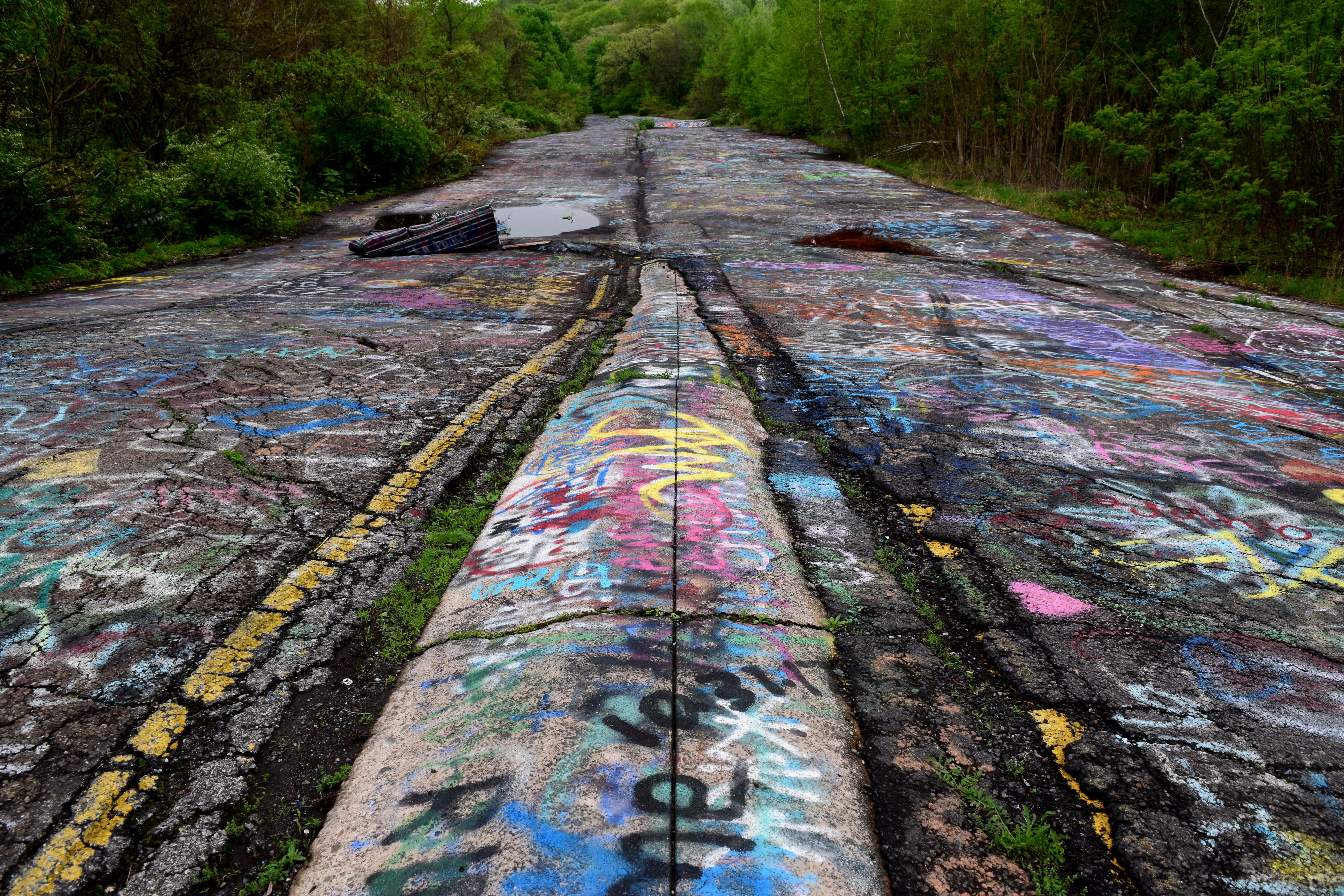
In any case, walking over to the start of the abandoned road, I got a taste of things to come in the wooded area near where I parked:


This tree both intrigued and concerned me, as it appeared to have been cut partly through and then left:

It appeared to be fairly stable at the moment, but nonetheless, it will eventually break completely, and I just hope that no one is around when it does inevitably fall.
And then here was the road:

This road has definitely earned its nickname of “Graffiti Highway”. It was hard to find a section that had not been painted at some point over the last 25 years.
The way I operated was to constantly scan the road looking for interesting tags to photograph, and also get overview photos of the road along the way. Many people put dates with their tags, and considering how many 2018 dates I saw, it’s clear that the road gets tagged very regularly, and the graffiti is always changing. Next time I visit Centralia, I imagine that what I see will be quite different.

This was one of only a few tags that were in the style of graffiti that you see in cities. Most tags were much simpler than this.

“Ben”. Based on the 215 above, I imagine that this tagger is from Philadelphia.

This was a fairly common occurrence: one person would draw something on the road, and then someone else would later draw a penis on it. Because why not.

An alien giving two middle fingers.

The road near the north end of the abandoned alignment, facing approximately north.

Graffiti-covered guardrail.

That weird “S” thing that every kid drew in middle school. I saw this in several places on the highway.

The first of many discarded spray paint cans that I would find.

SpongeBob SquarePants.

Facing approximately south in a section of the road where trees have grown through the median strip.

Still facing south, a little further downhill. This is near the center of the abandoned alignment. In the distance is an area affected by ground subsidence caused by the mine fire.

I think this is a drug reference?

One thing that I saw a number of times was social media handles painted onto the highway. A sign of the times, I suppose. This one belongs to @KylieFries.

A long and relatively deep fissure in the road caused by ground subsidence. I found photos of steam emanating from this fissure, but on this particular day, I didn’t see any, for a few possible reasons, including migration of the fire underground, and the temperature’s being too warm to make the steam visible.

A couch, abandoned on the side of the road, and also covered with graffiti. Surprisingly, this was not the only abandoned couch that I found here.
View from just south of the big fissure, facing south.

Another abandoned couch. This one is a sleeper sofa, and is in a more advanced state of decay, considering that the one side has more or less melted away.

An American flag, stuck into one of the cracks in the old road.

I saw a few of these, where one person tagged, and then another person later came by and modified it in an unflattering way. Such is the nature of the graffiti wall, or road, I suppose.

SEE ME.

Another discarded paint can.

Looking south near the bottom of the Graffiti Highway. In the distance is the end of the abandoned section. The active roadway is just over the ridge.

Facing north from the same location as above.

“Born to be mild”.

Another discarded spray can. I ran another shot of this subject as the photo feature shortly after returning from this trip.

Purple Minion holding a gun. And then someone added a dick to it. Because of course, why not.

Automotive rivalries are alive and well on the Graffiti Highway.

“Michele” in cursive writing.

Tree branch, previously painted red, sprouting new leaves.
Returning to the car, I took stock of what I had learned from talking to others that I had encountered. I was told that smoke often was seen coming from Odd Fellows Cemetery, and also about other things in the area. All in all, I had a little bit of exploring to do. First thing I did was to go around to Saints Peter and Paul Orthodox Cemetery. That was pretty straightforward, but getting to it was more challenging than I imagined. Google gave me directions that had me driving into St. Ignatius Cemetery, next to where I parked, but there were fences between where the directions dropped me and where I wanted to go. I ended up finding my own way there, which took me over some rougher terrain than I would have otherwise chosen. I don’t know if I would call it “off-roading”, but the fact that I now have an all-wheel-drive vehicle did make me feel a little more bold than I might have been if I still had the Soul. The road was unpaved and very uneven, and there were big puddles around. I followed a rule of keeping two wheels in a place where I knew that I could get good traction, and not going over anything that would make the car bottom out, and I was through it, arriving at the cemetery:


The cemetery itself, meanwhile, was fairly unremarkable:

I suppose that I could have hopped the fence and gotten some more detailed photos, but I was starting to run up against the clock, having spent the better part of three hours photographing the Graffiti Highway, which took up most of the time that I had allotted for this visit. There were more things to see, and not a whole lot of time left to find them and photograph them.
Next up was Odd Fellows Cemetery. For that, I wasn’t quite sure how to get there, as I wasn’t inclined to trust Google’s directions due to the quality of the roads through there (big hump in one spot that I didn’t want to take the car over), and so I ended up going through some very narrow and rough paths in the Honda before finally reaching it. I wandered around a little bit:


Like the Orthodox cemetery, I didn’t spend much time here, but further exploration in a future visit seems worthwhile.
On the way back from Odd Fellows Cemetery, I photographed a sign that I had spotted on the way in:
103.1.")
This sign advertised a state project that would work to reclaim the Centralia site, contract OSM 19(2000)103.1. In other words, mine reclamation, which involves restoring former mine sites to something resembling their natural state. No idea how that would affect the town site, though.
From here, I ended up going down the realigned Route 61 again, and spotted a random truck trailer for sale:


I guess you could call this stop “mildly interesting”. From what I could tell, you could buy the trailer for $1100 and haul it away, or you could buy the trailer along with the land for $6500. I imagine that the land is nearly worthless, considering that Centralia and nearby Byrnesville have both been abandoned due to the coal mine fire. And from the looks of it, that truck trailer had been there for a while.

The Honda, parked on the side of the road while I was photographing the trailer. I believe that the road to the left behind the car leads to the old Byrnesville town site, but I didn’t explore down that way.
And finally, here is the one remaining active church in the Centralia area:

This is Assumption of the Blessed Virgin Mary, a Ukrainian Greek Catholic Church. I only photographed it from the street, but a few folks that were there when I stopped by indicated a few interesting things on the property. If I return here on a future visit, I intend to tread carefully, respecting the fact that it is still active.
All in all, this was not a bad visit to this abandoned mine town, which I’d been wanting to view for a while. I think that I got a good overview, and I got some decent photos, despite cloudy skies (but at least it wasn’t raining like it was on the drive up). Centralia definitely seems worth a second look, since there was more than I could see in one day, plus I want a chance to photograph under clearer skies, and maybe see some steam coming from the ground. Elyse and I are planning a trip up to Scranton this fall, and we’ll probably visit Centralia then, either on the way up to Scranton or on the way home. Elyse has never been and wants to go, plus I want to see how much the Graffiti Highway has changed in the intervening months, and explore some areas that I didn’t explore very thoroughly, like the cemeteries. The Locust Ridge Wind Farm is also nearby, which I happened upon by accident, spotting a wind turbine while driving, and then turning up the site on Google Maps. I’ve wanted to photograph a wind farm for several years now, and this seems like a good opportunity to do that. I was going to check it out while I was on site, but then promptly forgot about it, and didn’t realize it until I was on my way home, on the other side of Harrisburg. Something for next time, I suppose…
Categories: Centralia, Honda HR-V (2018), Roads, Urban exploration