


Seeing Cumberland from the ground…
11 minute read
April 7, 2013, 12:28 AM
You may be familiar with Cumberland, Maryland. Whenever Mom and I go to Chicago, we take the Capitol Limited, and that train travels a route that goes through Martinsburg, Cumberland, Pittsburgh, Toledo, and South Bend, among other locations. When I take train trips, I like to look at the scenery. Some of it intrigues me, and it leads me do more research on it later. Take the Koppers facility in Green Spring, West Virginia. I always found it interesting to see these piles of neatly stacked lumber along the tracks. I researched it, and I enjoyed learning a bit more about what I had seen from the train. Towns are a similar idea. These little towns that the trains either pass through or stop in make me want to do more research. Unfortunately, many of these little towns are beyond my reach without incurring a lot of travel expenses, but for the places that I can reach, if they interest me enough, I’ll pay them a visit.
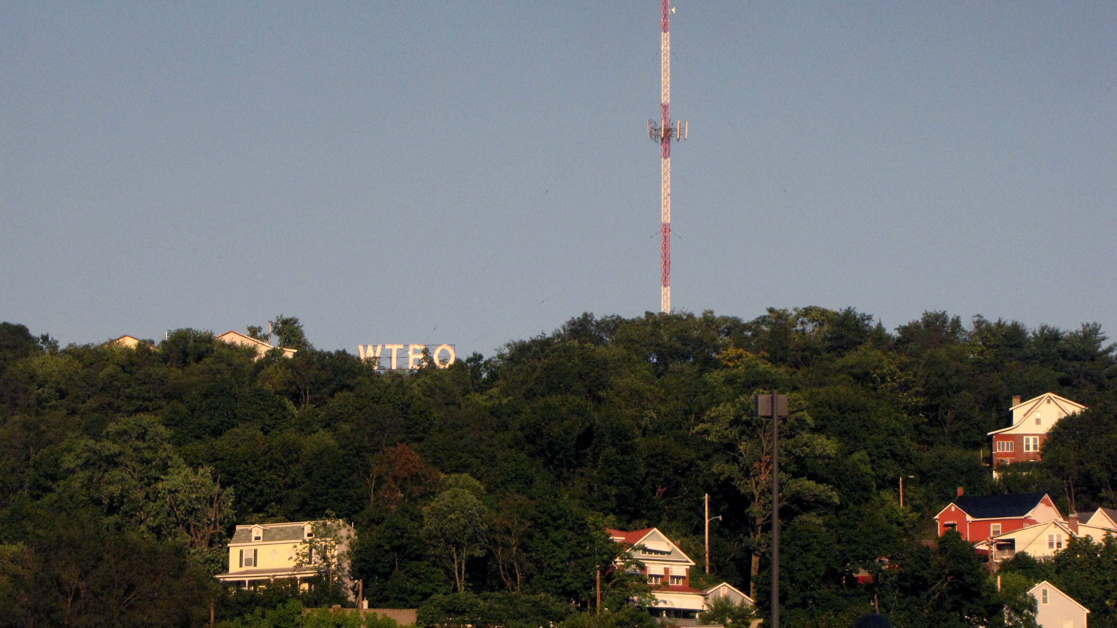
Cumberland was one of those places. The Capitol Limited spends a lot of time in Cumberland. Going west, the first thing that they do is a crew change, where they exchange engineers. Then they continue a little further west and do the passenger stop. That stop takes about ten minutes, and is also a “smoke stop”, where passengers who smoke are permitted to get off of the train and have a cigarette. While on the train waiting through the crew change and the longer passenger stop, I got to take an extended look at Cumberland. And I liked what I saw. I saw a town with some character to it, and I saw a few places that I would love to explore more deeply. I saw houses, I saw churches, and I saw the WTBO sign on Wills Mountain. And I was sure that there was much more that was interesting beyond what I could see from the train.
So this past Tuesday, I did exactly that. I grabbed the camera bag, got in the car, and headed off to Cumberland. This, by the way, is not exactly a short trip. Amtrak gives three hours and nine minutes to take the train from Union Station in DC to Cumberland. Google Maps gives two hours and 123 miles driving from my house in Aspen Hill to Cumberland Amtrak station by car. That’s going via the Intercounty Connector and I-370 to Gaithersburg, I-270 to Frederick, I-70 to Hancock, and then I-68 to Cumberland. I’ve done the drive on I-270 to Frederick a number of times in the past, and so I knew what to expect there. Interstate 70 through to Hagerstown took me over a number of hills and past the Appalachian Trail. I had taken I-70 west the rest of the way through Maryland when I went to Breezewood in 2006. Then I-68 was really awesome. The first thing you do is go through a highway cut through Sideling Hill, and then you go over a number of mountains before you arrive in Cumberland – directly in the middle of downtown.
However, since getting there is half the fun, I have a couple of highlights from the trip over. First of all, at the South Mountain Rest Area…

Have you spotted the grammar mistake that Maryland SHA made? Yes, that’s an apostrophe on the sign that does not belong. They need to fix that.
Also, along I-68, I needed to make another restroom break. I ended up making this stop in Flintstone, Maryland. There’s a gas station there, which was my original intent for getting off the highway in Flintstone, but right off the exit ramp, and way closer than the gas station, was a place called “Alpine Pantry”. It was a really cute place:


While the exterior is nothing to write home about, for someone who grew up in Stuarts Draft, the interior should look very familiar. Yes, it’s essentially a clone of The Cheese Shop in Stuarts Draft. It’s a lot smaller than The Cheese Shop, but it sells the same sort of products, and is also Mennonite-run. However, the most interesting thing was this pair of signs in the entrance:
 - Compliance requested on your future visits -\"")

The first sign was on the front window. The second sign was in the vestibule as you reached the second set of doors and entered the store itself. I found these kind of amusing. I understand that this is private property and they can say and require just about anything that they want, and I can understand communicating desired behaviors by doing it one’s self, but really? Explicitly asking this of the customers seems like overkill to me. It generated a lot of discussion when I posted these on Facebook, for sure.
Once I got into Cumberland, I did sort of a loop around the area to get my bearings. To put it nicely, I was disoriented within the town, as the highway just dropped me into the middle of the downtown area from an aerial structure. I needed to find the railroad tracks, find the Amtrak station, find the Town Clock Church, and figure out exactly what the extent of the town was so that I could devise a plan. Add another little surprise to the mix: Cumberland isn’t even a 3G area for Verizon. I got 1X extended network coverage out there. Thus data was a bit slow, which made using the phone GPS more challenging, as it took a few tries for destinations to register in the phone with the data issues. But once the destinations registered on the phone, things went well. I spotted the church, found where the town trailed off, and then navigated back to the Amtrak station using the phone GPS. And from there, I determined my boundaries. I was going to start east of the tracks, and roughly follow the tracks as I worked my way north as far as Town Clock Church. After photographing the church, I was going to cross over the bridge carrying Bedford and Frederick Streets, explore Cumberland’s Downtown Mall, and then end up back at the Amtrak station.
I parked in front of the Union Street Laundry Mat, which I had spotted from the train before. I stopped in at the Amtrak station to take a quick look. That was a little different than I expected:

I admit I didn’t quite know what to expect, but to see a completely unstaffed station like this was a surprise to me. There wasn’t even a Quik-Trak kiosk at Cumberland. Additionally, despite the “no smoking” sign, the facility smelled like stale cigarette smoke. But at least the facility was clean, and the restrooms were impeccable.
And from there, off to see the town. First stop was the Cumberland Shoe Hospital, which I had previously been unable to tell whether it was open or not. (Spoiler: it’s abandoned.) I got some photos of it:


That window was something I really should have played with more than I did. I really like the reflection off of the big window in the second photo, and I did play with the reflections on that window a little later on in the day. But during the day, I focused more on the letters than the reflections.
And from there, on to the church…

The church was difficult to photograph without getting power lines in the shot, so I ended up taking a lot of close-in photos to avoid the lines:


It also struck me then that this church has that “haunted building” look to it, and I kind of played that up in the photos just a little bit. I wonder if anyone ever thought about filming scenes for a horror movie here. It could work.
Then I photographed from the bridge…

From there, I headed to Cumberland’s downtown mall. That was a bit disappointing. First of all, the sun was angled as such that half of the buildings were in shadow – enough to make them not worth photographing. Additionally, trees in the pedestrian mall made many of the signs difficult to photograph, which reduced the appeal of things. I did, however, find an interesting labelscar on the wall of one of the buildings:

See the “Peoples Drug” labelscar? Apparently this location used to be a Peoples Drug back in the day. Peoples became CVS in the 1990s, and considering that there is a modern CVS/pharmacy store nearby, I’ll bet that this location converted to CVS along with the rest of the Peoples chain, and then later moved up the street.
And then to return to the Amtrak station and the car, I went through a pedestrian tunnel to go under the road and the tracks:

That was the unpleasant surprise of the day. The tunnel had standing water in it, trash of all manner, it was dark, it had graffiti, and it smelled awful. I didn’t want to know what that smell was, and after I shot a few photos in there, I left out the other end. I understand now why I saw so many people crossing the street and the tracks vs. using this tunnel. Not exactly a jewel in the Queen City’s crown, that’s for sure.
Then after that, I headed up to the WTBO sign. I knew that was going to be a quick mission: go in, get some photos, and then leave. The WTBO sign reminds me of the Roanoke Star in that whole sign-overlooking-a-town-from-above kind of way, but it’s different because it’s letters and not a symbol, existing to advertise a radio station. I kind of knew what to expect up there, as I did a tiny bit of research – just enough to know that the sign is on the grounds of the radio station. Thus I could plug the station address in and get there. Getting up there, I was met with a surprise: the radio station is in a residential area! I would have expected it to be a remote area, but no – a neighborhood, and from what I could tell, one of the nicer parts of town, too.
Going into this, my plan was to visit the radio station and ask permission to go out and photograph the sign, since the sign is, after all, on private property. However, I took one look at the radio station building and the parking lot, and quickly realized that no one was there. Apparently the station is operated remotely under normal circumstances. So I just helped myself. There was the sign, I didn’t have to go through anything to get there, and that was that. So the idea was to get in, get the photos, and get out, since I was technically trespassing, and I didn’t want a confrontation with anyone – but I still wanted the photos. And here they are:

View facing the WTBO sign.

View of the town from behind the WTBO sign.
All in all, not bad. I was pleased with how these came out, and was careful to be quick up there, but without compromising quality.
After that, I had lunch at a nearby Sheetz station, and then explored a bit by car, since I had time to kill before my next planned activity: trainspotting the Capitol Limited when it came through. I ended up finding my way to a boat launch adjacent to the Gene Mason Sports Complex. This is in a park situated along the Potomac River. Thus the other side of the river, unbeknownst to me at the time (I discovered this from research later), was West Virginia. There was a railroad bridge over the river (I think this might be where the Capitol Limited comes out?), and otherwise looks pretty natural. Definitely not like the Potomac River that I’m used to around DC…


From there, I headed back to the downtown area to do some trainspotting. My goal was the Capitol Limited, but I wasn’t going to turn down some CSX locomotive photos while I was there:

CSX locomotive 578, parked on the track.

CSX locomotive 9010 passes by, pulling a full load of freight cars behind it.

The end of the freight train.
As the Capitol Limited’s scheduled arrival time arrived, more people arrived at the station. I had a wonderful conversation with a woman who was from PG County, and who was going to school in Cumberland. Discussed the train, discussed Amtrak, and about Cumberland. She agreed with my characterization of the town as something of a dumpy little industrial town. It’s one of those towns where it has seen better days, as many of the buildings look very old, and a lot of the infrastructure looks quite old as well. I also saw a lot of broken glass all over the downtown area. No question that it was from broken bottles, but there was a lot of it – everywhere. We also discussed how different the culture was out there. Usually when I’m doing photography work, people generally leave me alone. Here, I had a lot of people strike up conversations with me. I found that odd, but such is small town USA, and Cumberland is definitely a small town. It reminded me of Covington or Clifton Forge in Virginia, though on a somewhat larger scale than those two towns. As a unit, Clifton Forge and Covington are a lot like Cumberland, in that they’re towns in very mountainous areas that feel somewhat isolated, as there are long strings of exits with no services at them around both areas.
And then the Capitol Limited arrived…

The Capitol Limited arrives at Cumberland.

The Amtrak employee on site at Cumberland interacts with the people on the locomotive.

The train departs Cumberland. Next stop: Connellsville, Pennsylvania.
And with my trainspotting done, there was only one last thing to do, and that was to check to see if the WTBO sign was lit, and go photograph that. But first, I got a few more photos of Cumberland Shoe Hospital, and played with the reflections on the window a little bit:


Not bad, don’t you think?
Then returning to the car, I spotted the WTBO sign once I got away from the train station, and the sign was lit up. And so I headed up to see it again. This time, I knew the drill, and rode right up the mountain and parked. And here it is, all lit up at sunset…

View facing the now-lit WTBO sign. Sadly, half of the “W” was burned out on this particular evening.

View from behind the sign at sunset, facing the town.
And with that, mission accomplished! It was now time to head back home. Not a bad day, if you ask me. I definitely want to go out to Cumberland again, and focus on a few things that I didn’t get to focus on this time around. I saw a number of churches around that I didn’t get to visit this time, plus I want to try for some better photos at the WTBO sign. The daytime photos weren’t bad, but I thought that the nighttime ones were somewhat lacking. I should haul out the tripod for those, as the above shots were handheld. I don’t think they’re necessarily bad shots, but I think I can do better. But now that I have been there and have gotten a feel for the town, the next time will be easy, though when “next time” will be, I don’t know. And look for a Photography set from this trip to Cumberland at some point. Not entirely sure what it’s going to feature, but it should be nice when it’s done.
Categories: Amtrak, Cumberland, Photography, Railroads, Travel