


What to do with Shenandoah Acres?
8 minute read
September 2, 2012, 8:39 PM
For the last few years, I have been involved in a Facebook group called “Remembering Shenandoah Acres“. This group is built around discussing memories of times spent at the Shenandoah Acres resort in Stuarts Draft that closed after the 2004 season, but most discussions anymore center around complaining about the state that the property is now in.
For those not familiar, Shenandoah Acres was a facility that billed itself as “America’s Finest Inland Beach”, owned and operated by the Blacka family for many years. It had a campground, there were cabins, and a motel building on the property. The facility also had tennis courts, trail rides on horseback, and miniature golf. However, the centerpiece of the facility was a manmade lake with a beach around it, playground equipment in the water (including one slide about two or three stories high), and a large tower in the center that offered a zip line ride. The facility was a popular tourist attraction, and the lake was also very popular with locals during the summer season.
In the years that I’ve been familiar with the facility, one of the merry go rounds in the water was replaced in 1995 by “Clyde the Slyde”, which was a small slide built inside a dinosaur sculpture, and the zip lines were dismantled in the late 1990s or early 2000s and replaced with the “Pink Zipper” water slide. Additionally, the roof of the original beach house collapsed due to excessive snowfall in 1997, and was replaced with a new structure slightly to the northeast of the original. The facility closed after the 2004 season because, according to the owner at the time, whom my family went to church with, the cost of insurance finally became too much to bear. My family went to Shenandoah Acres from 1993 until about 1996.
Here’s what the facility looked like in operation:
. This photo is from 1997 or later, based on the absence of the original beach house. This photo shows most of the amenities in the lake, including a merry go round (far left), the tower with zip lines (center, in the distance), the big slide (right side of photo), and Clyde the Slyde (behind the big slide).")
Photo: Tim M. Hanger
This is the view from the east side of the lake, across the lake from the beach house (i.e. this was the “far side” of the lake). This photo is from 1997 or later, based on the absence of the original beach house. This photo shows most of the amenities in the lake, including a merry go round (far left), the tower with zip lines (center, in the distance), the big slide (right side of photo), and Clyde the Slyde (behind the big slide).

Photo: Tim M. Hanger
This photo, taken in the 1995 or 1996 season based on the presence of both Clyde the Slyde and the original beach house, shows the volleyball net that was set up in the lake.

Photo: Rick Woodall
This photo shows two men going down the zip line, taken from the top of the tower. On the cable ride, people would hang from the handholds and ride the cable to the end of the lake near the beach house.
, was taken at the other end of the cable ride. The two posts in the foreground hold the cables in position, and the cables themselves are anchored into the ground. Additionally, note a second slide in the water in the right side of the photo.")
Photo: Steven Barstelmann (but probably now in the public domain due to its age)
This photo, showing the original wood tower (which was replaced with a concrete-and-steel tower of similar design before my family moved to the area), was taken at the other end of the cable ride. The two posts in the foreground hold the cables in position, and the cables themselves are anchored into the ground. Additionally, note a second slide in the water in the right side of the photo. The beach house is out of frame to the right.
After Shenandoah Acres closed after the 2004 season, the property was sold to Goodfaith LLC, which was owned by the Eavers family (a family that owns like half of the town). And since then, not much has happened with the property. When I photographed the property in 2009, this was the view:

This is the tower with the Pink Zipper slide on it, in May 2009 (you may remember that this was also the photo feature around that time). The zip line ride was on the opposite side of the tower from where the slide was located. The lake level is much lower than it would have been when the facility was in operation. There are markings on the tower and the piers that support the slide that approximate the original lake level. The tower, along with the big slide and all of the remaining equipment in the lake, was demolished later in 2009, leaving only two concrete platforms in the lake. One supported the big slide, and the other never had anything on it other than a lifeguard chair in my experience.
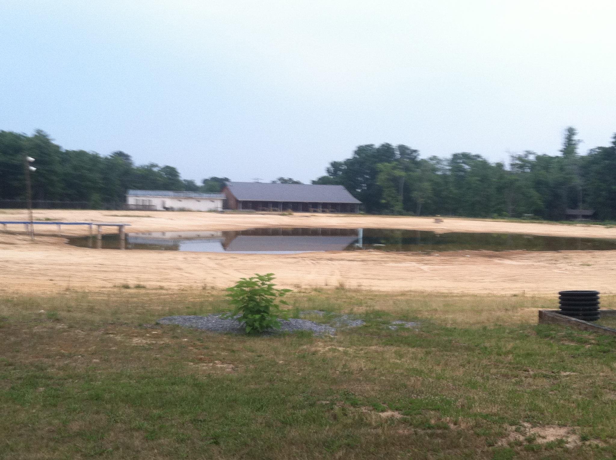
A photo from this year shows the lake level far lower than in 2009, and the lake is almost completely stripped of everything that made it Shenandoah Acres. This made me start to see the property as not so much a decaying ruin, but as a blank slate. What could be done with this property that will make it a productive part of the community, and also have a chance of being successful again? First of all, this is the size and shape of the property that we’re dealing with:

Image: Augusta County
The lake itself is just slightly north of the center of the property, on the west edge next to the road. That’s actually a lot of land, and more than I expected before I did the research. I didn’t expect the property to extend so far north and south, and instead to be more centered on the lake itself.
The challenge here is to figure out a use for the property that preserves the lake and makes good use of it, and also fits well with the community. That last part is really hard. Living in the Washington DC area, when a property needs to be redeveloped, the usual response is mixed use, building something like Pentagon Row with shopping on bottom and housing on top. In Stuarts Draft, that wouldn’t work, because there’s not enough population to support that much shopping. Staunton and Waynesboro have only recently become places where bigger name retailers want to locate (like within the last ten years), and so I couldn’t imagine major retailers wanting to locate in Stuarts Draft. Especially so with this property, which is a bit removed from other shopping in Stuarts Draft (shopping in Stuarts Draft is mostly located along US 340). Additionally, Shenandoah Acres is located in an area that is very residential. To get to Shenandoah Acres going south on Lake Road from Route 610, you go past a number of houses, and then beyond Shenandoah Acres are more houses until you enter Big Levels, which is part of George Washington National Forest. To the west is Dodge Street, which is a standalone residential street, and then west of Dodge Street is my parents’ neighborhood. East of Shenandoah Acres is Acres Sand and Stone, which is industrial. Additionally, there are two churches – Stuarts Draft Mennonite and Ridgeview Baptist – nearby.
With these sorts of surroundings, that also means that walkability is practically zero. There’s nowhere to walk to. Walk Score gives the area an 8 out of 100. And Stuarts Draft has no public transportation. So this is a car dependent area, and there’s no getting around that. The nearest gas station and the nearest grocery store are approximately 2.5 miles away, and it involves a railroad crossing, and there are no sidewalks for the first mile and a half.
So what did I come up with for this area? A community for adults 55 years and older, with independent and assisted living facilities. The way I see it, using the Shenandoah Acres property in a similar way as it had been in the past is out of the question for the same reason that the Blacka family sold it: insurance. Too much money. Likewise, the lake’s function for the local community as a place to swim has been replaced by Stuarts Draft Pool, which is a more centrally located county-operated facility. However, the lake itself seems to have some value to it, though I would demolish just about everything else on the property.
For the lake, I imagine that it could be the centerpiece of this new community. For that, renovations to the lake would eliminate the beach entirely, and replace it with new landscaping, raising the land around of the lake to make it even with street level, making the lake appear sunken into the ground slightly. This new raised land would house walkways around the lake. For an example of what I’m talking about, see the lake at Washingtonian Center in Gaithersburg, Maryland. In the lake itself, all remaining platforms and structures from previous uses would be demolished, and perhaps the lake’s footprint might be expanded to change it from a round area to something with branches reaching other parts of the property. Then a giant fountain would go in the middle of the lake at approximately the location of the old tower. I imagine this fountain as being similar to the one in Newman Lake at JMU. The renovated lake would not be open to swimming, but could be used for casual fishing. Perhaps a fishing pier could be constructed somewhere along the lake, like in the area where the big slide used to be.
On the east side of the lake, across from the fishing pier that I propose, I would construct some sort of clubhouse. This would be the center of the community, and would contain community space for events, a fitness center with indoor pool, and a restaurant or other dining facility, among other things. Outdoor activities could go near the clubhouse, like tennis courts. I also imagine lots of open green space in this area of the property. However, I believe that the size and shape of the property precludes building a golf course. Comparing the Shenandoah Acres property to the Waynesboro Country Club, which has an 18-hole golf course, via Google Earth, I determined that a golf course would use the entire property, and not leave any room for any other amenities, including the clubhouse.
Then much of the remainder of the property would be housing. I imagine a mixture of single-family homes and apartment-style units, fronting the north and south sides of the renovated lake and extending to the ends of the property. Walkability within the community would be paramount, with sidewalks and curbs the rule rather than the exception, and painted crosswalks at intersections. The idea is that people would not need to use their cars while on the property – only to travel off the property.
The west side of the lake would not have any new construction on it other than getting rid of the beach and replacing it with new landscaping as described earlier. The lake’s position relative to Lake Road precludes construction on that side of the lake, but it would provide a view of the lake’s new fountain from the street.
Lastly, nomenclature: the lake would need to receive a formal name, as would streets on the property and the property itself. Google Earth lists the lake as “Mountain Lake”, which is a misnomer (it’s in a valley), and too generic. I would suggest naming the lake in honor of the Blacka family, who made Shenandoah Acres what it was in its heyday. Likewise, a street in the new community should be named for the Blackas as well. As far as naming the community, I feel that the name “Shenandoah Acres” is still strongly associated with the site, and that could be carried on for a senior community. Something like “The Village at Shenandoah Acres” sounds pretty nice.
So there you have it, I suppose. I am not an urban planner nor do I play one on the Internet, but to me, as someone who lived near Shenandoah Acres for 15 years, I feel that might be a good way to turn what is currently something of an eyesore into something beautiful again, and bring it back into the community.
Web site: Read Open Roads on Shenandoah Acres
Categories: Shenandoah Acres, Stuarts Draft