
Elyse and I recently made a trip down to Augusta County to see my parents, and we both photographed a bunch of stuff with my drone while we were down there. So all in all, we had a pretty productive time. I have gotten pretty proficient in flying my drone around things, and I’ve gotten some nice photos. The goal of the drone photography this time was to duplicate a lot of what I did in my earlier entry about the area in Microsoft Flight Simulator, but in real life. All in all, I had a good time, and I liked the results, as I flew around Staunton, Waynesboro, Afton Mountain, and Stuarts Draft.
In Staunton, I first got aerials of the old DeJarnette Center, which is an abandoned children’s mental hospital that closed around 1996 in favor of a newer, more modern facility nearby. If this place sounds familiar, it’s because I’ve photographed it before. So here it is:


I also photographed the Augusta County Courthouse in downtown Staunton:


And of course, I also got a selfie at the corner of East Johnson and New Streets:

In Waynesboro, we first stopped in at Eagle’s Nest Airport, which is a small airport just outside of the city limits. We didn’t fly the drone there for obvious reasons, but Elyse wanted to see what it looked like in person, since she tends to fly a lot of stuff out of there in the flight simulator game.
We then headed over to the former Kmart. That store, which opened in that location around 1995 (vacating an earlier location across the street that is now a Big Lots), closed during Kmart’s recent bankruptcy. Interestingly, they left the signage up after the store closed. Because of that, I had wanted to photograph this store, so I did:


I was originally planning to just do some ground-based photography and call it a day, but then I thought, you know, I have this drone with me, so why not? So I went for a flight:


Then we went over to the Walmart in Waynesboro, where I used to work in the mid 2000s, and went for a flight:


While I was up in the air, I photographed a few other things. This is the Dupont Community Credit Union main office just down the street:

This is the Aarons/Goodwill building in between the credit union and the Walmart:

This is the sign for the Coyner Park shopping center across the street from Walmart:

We then headed over to 1140 Shenandoah Village Drive, which is now the operations center for Dupont Credit Union. The building previously housed CFW Information Services (later operating as Telegate USA), where I worked as a directory assistance operator from 1997 until the business closed in 2002:


And for the record, I hate that row of trees that the credit union planted along the side of the building. It’s ugly, though I assume that it was done for glare-reduction purposes, as there are several large windows on that side. Here’s what it looked like without the trees, in December 2001:

If you ask me, it looks much better without that line of trees.
We then went up to Afton Mountain, where we visited the usual suspects as far as abandonments go. Last time I talked about that area, The Inn at Afton was still renting out rooms, with about eight rooms still in service. From the looks of it now, though, the motel is completely defunct, and is now abandoned right along with everything else, save for the tourist information center. The room previously being used as an office appeared to be unoccupied, there were abandoned vehicles in the lot, and it appeared that there were squatters living in rooms that I had previously learned were not being rented anymore (at that time, all rooms being rented were on the first floor, facing the parking lot). I kind of wanted to go up to the building and pull the fire alarm just to see if it worked, because it’s possible that utilities have been disconnected. I resisted the urge, because there was a good chance that it still worked, and that would have required that we make a quick escape from the area.
In any case, here it all is:


And a photo of Elyse, who caught the drone in her hand:

That was my first time landing it with the intention of someone’s catching it, rather than on the ground.
Elyse also took it up at this point and got some of her own photos. Meanwhile, I got some photos of the drone while she was landing it:


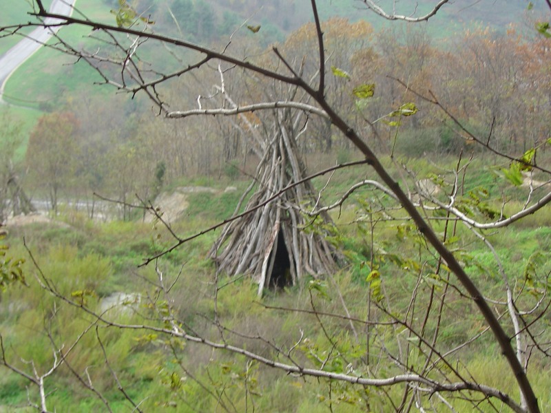
While we were up here, I also used the drone to investigate a landmark that I had wanted to check out for a while, but had never gone to the trouble of hiking up to. There was a little teepee made out of wood just east of Skyline Drive. I’d known about it for a very long time, but didn’t want to actually, you know, hike up to it, because I had no idea what was the best way to hike up there, plus I didn’t know if it was worth the effort. So I investigated with the drone. The challenge here was that flying drones is prohibited in national parks as a blanket rule, but while the teepee was outside of the park, finding a safe place to fly from was a challenge. My first attempt was to fly from the I-64 scenic overlook just past Exit 99, but I soon discovered after taking off that I was too far away. In other words, I went out of range before I got anywhere near it, and when the drone goes out of range, it automatically starts flying back to its start point until it gets back in range. I did, however, get some decent shots of the freeway and such from there:


I also wanted to see how good the HR-V was as a landing platform, so I landed it on the moon roof, as Elyse watched from inside:


Turns out that the HR-V is not a good landing platform, because the roof isn’t flat. Once I touched down, the drone slid down the windshield and landed on the wipers:

Oh, well.
My next attempt to reach the teepee was to do it from an area near Skyline Drive. The goal was to find somewhere nearby that was off NPS property and fly from there. I went to a small parking area next to the interstate but on the connector between Skyline Drive and the Blue Ridge Parkway. Then there was an opening in a fence that led to the weather station next to the freeway, but was well above it. I sat down on a utility box, and took off. That ended up working, with my being able to investigate. Here’s what I saw:


That last photo should also give you an idea about another reason why I was hesitant to go up there. That is a rather rugged area next to a cliff, which leads down to the freeway. It’s perched right up there.
In investigating with the drone, I was surprised about how little there was to it. I was expecting a more substantial structure, but I suppose that time has caused it to deteriorate over the years. Adam Froehlig photographed it in 2004, and it was much more substantial back then. I don’t know if other humans removed some of the branches, or if they just fell away naturally over the years, but it’s definitely a lot less than it was. I’m kind of impressed that it’s still there at all after all of these years, but who knows how much longer it will be there.
And a bonus shot of me while in the process of landing:

From there, we headed down to Stuarts Draft. I wanted to photograph my old middle school and my old high school from the air, and they were close enough that I could get them on the same flight. We parked in a nearby shopping center, I walked over to a clearing next to the road, and up we went. First, Stuarts Draft Middle School:


Then, Stuarts Draft High School:


And then I landed it:


We then went down to the corner of 608 and 340, where I photographed the intersection and surrounding area:
 and 340 (bottom left to top right). The Exxon and Dairy Queen are at the top of the photo.")


Then I turned around and photographed the Walgreens (built as a Rite Aid) where I parked to do this flight:


And unfortunately, that last photo of the Walgreens was the last photo that I got to take with this drone. Our next target was Finley Memorial Presbyterian Church, where we used to attend church (and my mother still does), and when I took off from there, I flew up into a tree branch that I thought that I was clear of, which caused the drone to stall and fall 20 feet to the ground, where I broke off a motor. That was the end of that:

Yeah, there’s really no fixing that, at least as far as mere mortals go. Good thing I bought the warranty coverage from the manufacturer, because they’ll either repair it or send me a new drone. Woomy, meanwhile, had his own opinions about my accident damage:

“I don’t like that!”
So all in all, I had a good time flying around the valley with my drone. I think I got some decent shots, and once I get the drone back from the repair shop, I will continue to work on my skills, and be far more careful about my surroundings when I’m flying.