


“Not fooling anybody” in DC…
October 31, 2014, 11:50 AM
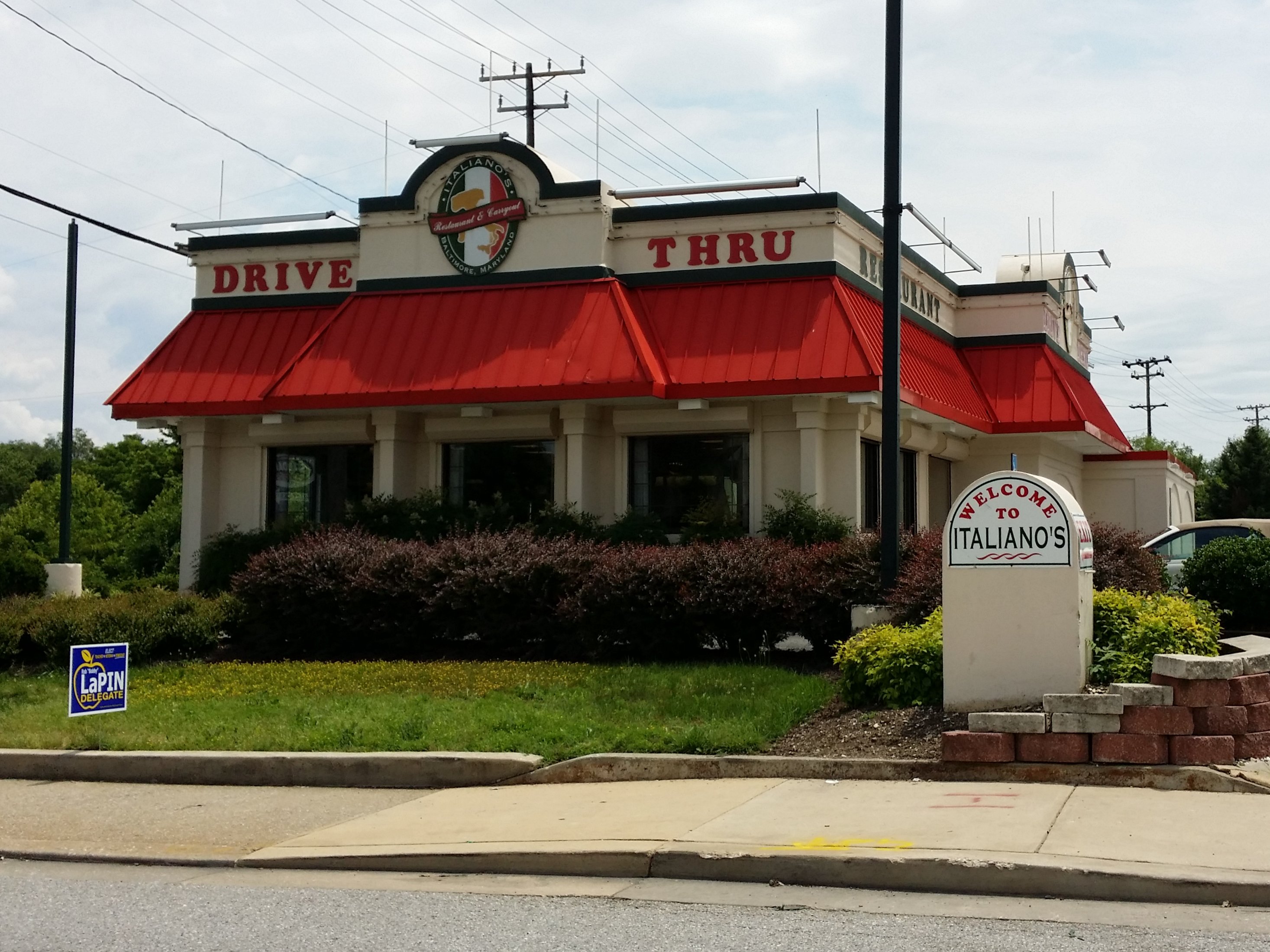
This past Saturday, I did some photography in Washington DC, but not the usual sort of photography that I do when I head into DC. This time, I photographed repurposed commercial buildings, i.e. buildings constructed with the standard architecture for a specific chain, and now operated by a business other than the one that the architecture would suggest. “Not Fooling Anybody” on Reddit, where people share photos of such conversions, describes it as “former chain businesses that have been converted to other uses, yet still strongly resemble their former use.” Some people might call these bad conversions, but I prefer to call them “obvious conversions”. After all, some conversions can look quite elegant, such as Italiano’s in Baltimore, which is a former KFC, but nonetheless still resemble the former tenant’s distinctive style.
It’s also worth noting that these sorts of buildings have no historical value of any kind, so they’re worth photographing while they’re still there, because they will be demolished when someone comes up with a more lucrative use for the land.
For this trip, I did my research. I had assembled a list of some places that I had spotted over the course of going wherever over the years, and then augmented that with some others that the folks on the DC subreddit brought to my attention, particularly on some corridors that I had never had any reason to travel under normal circumstances, such as Bladensburg Road and Benning Road. I then used Google Street View to visually verify all of the suggestions so that I knew what to look for in the field, plus I also did a virtual drive down a few roads using Street View to see if there were any others, as some corridors tend to be just teeming with them.
When all of the research was done, I had about twenty places that I planned to visit. I mapped them all out, and then determined a travel order, going through the city mostly in a north-south order, with some zigzagging at times. My route took me down Georgia Avenue, then through Brookland, along the Rhode Island Avenue corridor, through NoMa, down Bladensburg Road, along the Benning Road corridor, down Pennsylvania Avenue SE, and then back to Benning Road, before reaching Southern Avenue, which forms DC’s southern border with PG County. Then from there, I went out to Waldorf to see what all was out there, sort of giving myself an endpoint rather than just looping back around DC when I was done.
And so I began my journey on Georgia Avenue, just south of Silver Spring:

First up was Eddie’s Soul Food, which is near the intersection of Georgia Avenue and Kalmia Road NW, near the border with Montgomery County. This is a former KFC, where the roof was painted and the cupola was removed after KFC vacated. The building would have looked something like this as a KFC, though this one is smaller, and of a somewhat unorthodox shape. Considering that there is a KFC/Taco Bell a block away, this location was most likely vacated due to a move.

The sign at Eddie’s Soul Food is the standard KFC design, minus the chicken bucket on top.

Two or three blocks south on Georgia Avenue NW is Ledo Pizza, a local chain of pizza restaurants, in this case housed in a former Pizza Hut building. It would have looked similar to this, complete with roof hump, when it was Pizza Hut.

Further down on Georgia Avenue is a Pizza Hut, housed in a former KFC. It would have looked like this (and this) as a KFC, with a large cupola on the roof. According to historical Street View imagery, this building had most of its cupola in September 2007, but the cupola had disappeared by July 2009. The sign, however, is still quite vintage.

Further down Georgia Avenue, this Enterprise Rent-A-Car facility is housed in a former Burger King.

And if the building wasn’t enough of a clue, the sign is the classic Burger King shape, with Enterprise’s sign replacing the bun-halves logo.
Enterprise was my last stop on Georgia Avenue. From here, I headed into Northeast, near Brookland:

Most people should recognize the shape of the building that now houses Bennett Babies on Michigan Avenue NE. It used to be a Pizza Hut, though this one did not have the trapezoidal windows like the one that’s now Ledo Pizza.

This one is a little unusual, and does not really fall under the same category as the rest. This is the former Newton Theatre, which began life as a movie theater, became a music performance venue, and now is a CVS. While the building still resembles a theater on the outside, and there’s a bit of exterior detail to give a nod to the former usage, the interior is entirely unremarkable, and looks like a regular CVS. I wonder what interesting features this building is hiding, though.
From there, I made my way to Rhode Island Avenue NE:

This building is a former Church’s Chicken, and would have looked like this as Church’s. The oval-shaped sign is also from it’s time as Church’s, and would have looked like this back then. The building took on its current form between July 2009 and June 2011. Prior to that, it was split between the mobile store and a clothing store. I don’t know when the building stopped being a Church’s.

Up the street from the former Church’s is the Golden Skillet, which is housed in a former Dunkin Donuts/Baskin Robbins. According to Street View imagery, the Dunkin Donuts/Baskin Robbins closed between November 2007 and July 2009, as the November 2007 image shows it in its original form, while the July 2009 image shows it in its present form.

A little bit down the road from the previous two, Flip-It II is another former Pizza Hut. It’s been at least two different places since it stopped being Pizza Hut, as it was a seafood and steak place as of July 2007, it was up for lease in July 2009, and then Street View imagery in June 2011 shows it in its current form.


This 7-Eleven is a former 1980s-style Burger King. It would have looked similar to this when it was Burger King. According to Street View imagery, this housed a branch of the DC DMV until some time between July 2009 and July 2011. The only imagery that shows the building as a 7-Eleven is from this year, which makes me think that this was a recent change.

Further down Rhode Island Avenue, this Big Lots and Save a Lot together were formerly a Safeway.

Next to that, this building that now houses Forman Mills began life as a Zayre store.

Photo: Google Street View
This building, formerly a KFC, seen above in Google Street View imagery, is what sometimes happens to these older retail and restaurant buildings. I first spotted this building when I was down this way in March. When I went to photograph it on Saturday, it had been demolished, as I found a hole in the ground where I had expected to see Pizza Mart. Such is the fate of these buildings, after all. They have zero historic value in most cases, and are subject to demolition when the next new idea comes along.
After this, I left the Rhode Island Avenue corridor and headed over to NoMa:

This McDonald’s on New York Avenue is not a conversion as far as I know. It appears to have been built as McDonald’s, however, the architecture is interesting. I don’t know about you, but I’ve never seen a two-story McDonald’s with a mansard roof before. Most two-story McDonald’s locations that I’ve seen have fairly plain exteriors. That made this one somewhat remarkable to me.

Up the street and around the corner from the McDonald’s is New York Pizza, housed in a former KFC. Street View shows this location as being KFC as late as November 2007. It was vacant for a few years, and then first appears as New York Pizza in imagery from June 2011.
From here, I headed over to Bladensburg Road:

Dolphins Fish and Chicken, located across the street from Metro’s Bladensburg bus garage, is housed in a former Wendy’s. This is apparently a very recent opening, as the current Street View imagery (August 2014) shows grand opening signage on it. All Street View imagery prior to this shows an abandoned building. It most likely would have looked like this when it was Wendy’s.

This building, now a 7-Eleven, at the intersection of Bladensburg Road and Neal Street NE, has me stumped. I spent far too long trying to figure out what this was built as. It looks like a chain built it, I couldn’t figure out what that chain was. There appears to have once been an entrance on the Bladensburg Road side, but I can’t figure out the architecture. The sign appears to have been reused, but I don’t know what company that sign shape belonged to. Historical Street View imagery shows that it became a 7-Eleven in 2012. Before that, it was a nail place, and the mansard was shingle. If you recognize it, let me know (leave a comment!).
[Note: I was informed on December 13, 2014 that this location was constructed as a Holly Farms Fried Chicken, and would have looked similar to this in that guise.]
Then I made a left turn onto Benning Road:

This 7-Eleven on Benning Road NE is housed in a former KFC.


This building, which now houses HipHop Fish & Chicken, was the one that I was most looking forward to when planning this trip. It’s very much a mutant at this point. The building began life as a Hardee’s, and the standard architecture for Hardee’s is clearly visible in the back part of the building. Then the building became a Popeyes. When Popeyes takes over a building, they usually make some heavy modifications to the building to introduce their own standard architecture. Thus the front was heavily modified during the conversion to Popeyes, though some of the sloping from Hardee’s remains. The building was Popeyes until at least August 2011, but by May 2014, they were gone. I don’t know if the white color of the building was done by the current owners, or if that’s a paintout by Popeyes.
From here, I detoured off of Benning Road and headed down Pennsylvania Avenue SE:

This former Pizza Hut on Pennsylvania Avenue SE is now another New York Pizza location. Inside, it still looks very much like a Pizza Hut as well.
Then I went down to Benning Road SE:

This is another former Church’s Chicken, now housing America’s Best Wings.
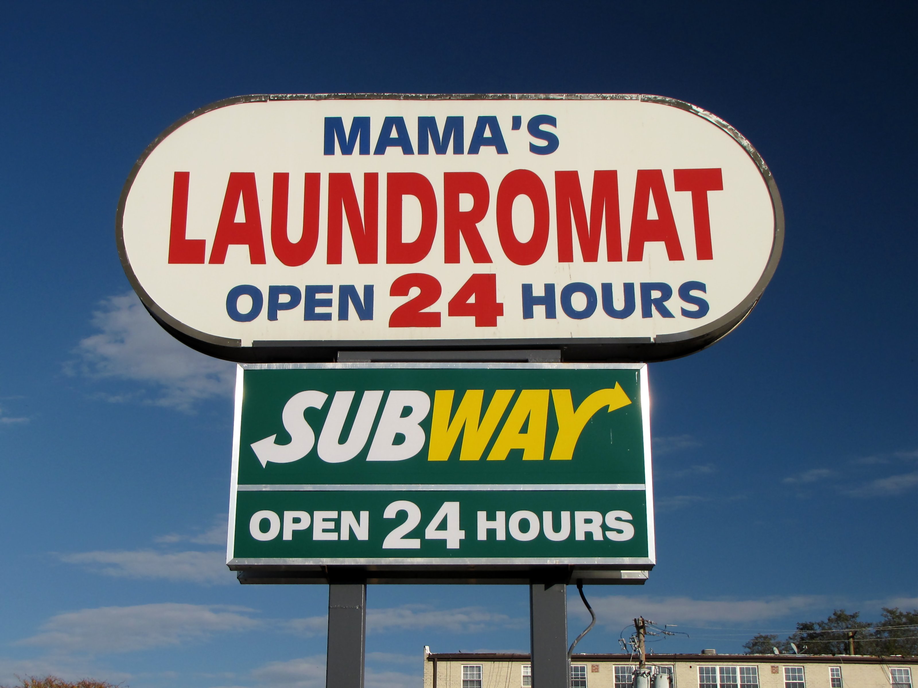
However, the sign for Church’s Chicken didn’t go with the wings place. Rather, it’s now advertising a laundromat at the end of the shopping center.
. Still, I wonder if the dental work done here is \"Finger Lickin Good\"?")
I found Smile Center Dental in this former KFC by accident after making a wrong turn. According to Street View, it was still KFC as of December 2007 (and the 7-Eleven next door, much to my surprise, was a different business). Still, I wonder if the dental work done here is “Finger Lickin Good”?

This former 7-Eleven, on Benning Road SE near the DC line, is now Nite N Day Food Store. It’s now orange, but the architecture screams “7-Eleven”, with the store’s apparently reusing the original 7-Eleven sign frame.

And finally, one more 7-Eleven on Southern Avenue SE, though it’s technically located in PG County. This one has a different roof style than the other, but its origin as a 7-Eleven is indisputable.
From there, I made a left turn on Branch Avenue, and headed out to Waldorf. The purpose of going out to Waldorf was to check out this little town in Charles County that I had been to once before on a business trip. In 2011, my then-boss, two others, and myself went down to Waldorf to visit Sheads and Associates, a company that did various direct mail caging services for the organization. The visit led to expansion of the relationship with Sheads, but it was an in-and-out trip, so I didn’t get to see much of Waldorf other than what my GPS gave me to get to and from Sheads. So now, I got to see Waldorf.
It was starting to get dark by the time I got down there, but I did quickly spot something that I had seen on the Internet. Do you remember the “lumber car” photo that had made its way around the Internet around 2000? That was taken in Waldorf, in front of IHOP. I posed my car in the same spot. Compare:


Not a bad pose, if you ask me.
Otherwise, while I was in Waldorf, I went down Route 5 as far as the St. Charles Towne Center shopping mall. It wasn’t a bad mall, though it was a bit generic. This trip to Waldorf, even if it was a relatively short visit, left me thinking that this might be a town worth exploring further. Seems like there could be all sorts of “mildly interesting” things in it. Don’t know when I’m going to get down there again (and it may be a while), but it seems to be worth another look.
And then as far as converted buildings go, I’m planning another one of these sorts of field trips. The next one would be in PG County. Over the course of driving the bus these last few weeks, I’ve spotted quite a few converted commercial buildings – enough to make another day out of it, both in the Landover area and along Indian Head Highway. One is a Marina-style Safeway that’s been converted to an AutoZone. Look for that one of these days, though with the days’ getting shorter and the time change, I’m not entirely sure when it’s going to happen. But we’ll see.
Categories: Converted buildings, Maryland, Netculture, Washington DC