


Back to Cumberland…
October 11, 2014, 7:56 PM
On October 2, exactly a year and a half after my first road trip to Cumberland (where I produced a photography set), I was back out that way again. The purpose of this trip was to explore the downtown area a little bit more deeply, make some photo spheres, and check out a few things that I had missed the last time I was out there for one reason or another.
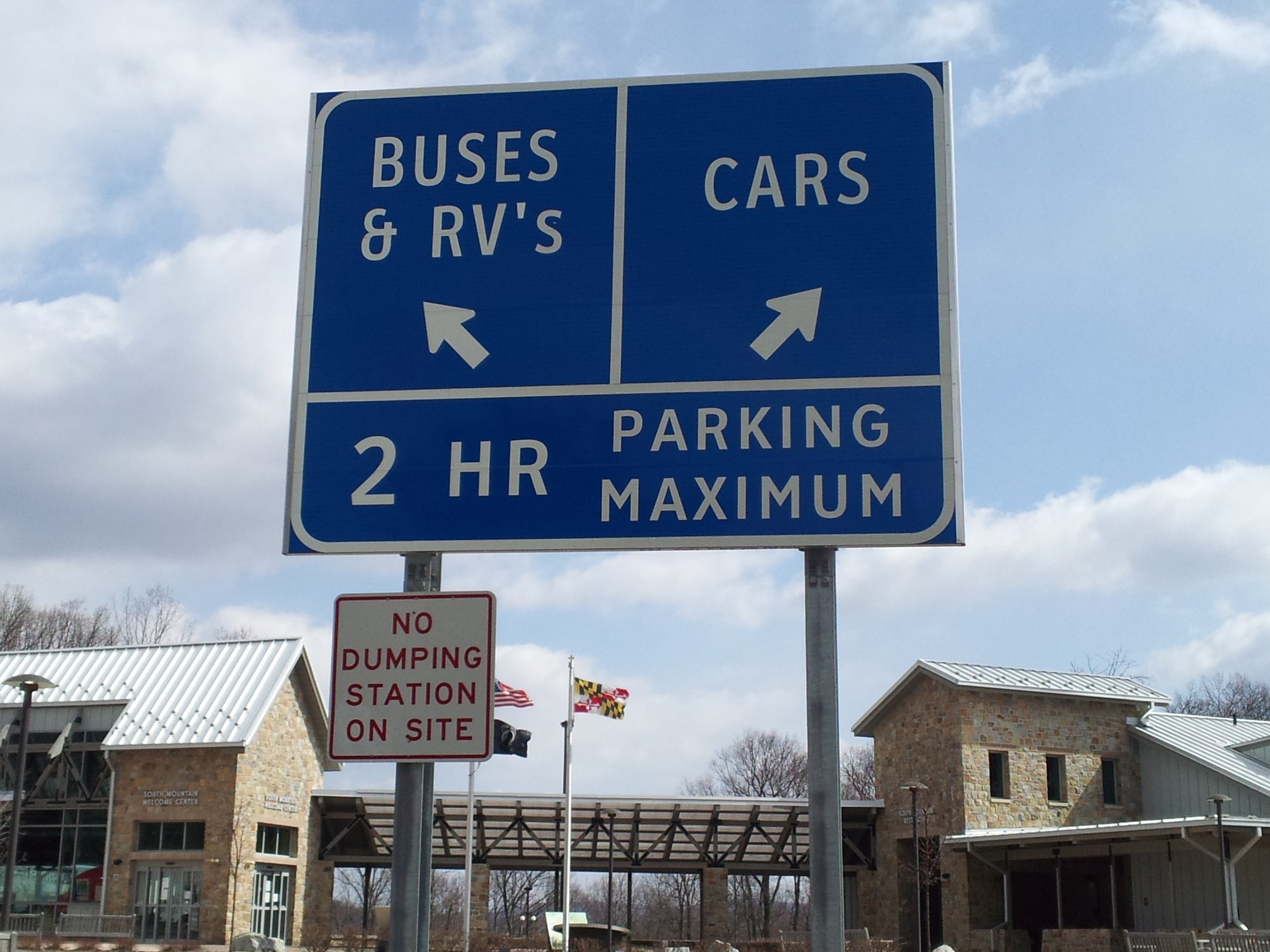
I had two planned stops on the way out. The first was at the westbound South Mountain rest area and welcome center on Interstate 70. Besides its being a logical spot to take a break, I wanted to get some photo spheres while there, plus I wanted to get updated photos of something that really bothered me on the last trip to Cumberland. In the Journal entry for the April 2013 trip, I discussed an errant apostrophe on the signage directing motorists to parking, where “RV” was pluralized using an apostrophe. The rule of thumb when it comes to pluralization in English, by the way, is that an apostrophe is never used to form a plural. Ever. I filed a request about this with SHA, which became case #SR-0198410, in early May of this year, to get it fixed, referencing the photo from 2013. I heard back from SHA a few days later, where they promised that they would have the apostrophes removed by the end of the month. When I was through that area again in mid-June, I swung by the eastbound rest area (opposite side) to check to see if they kept their promise. They did, as they scraped the apostrophe off of the sign. This left a somewhat inelegant result:

The apostrophe was gone, though the awkward spacing, as well as a labelscar, made it apparent that an errant apostrophe was once there. But I could live with that result. Still, I was quite pleased to be greeted by this when I stopped by on this trip:

Turns out that the scraped-off apostrophe was a temporary fix while they made a more permanent solution, i.e. a plate with a new “s” on it to correct the awkward spacing and hide the labelscar. This was a far more satisfactory solution than the original fix.
Continuing on down the road, the next stop was the rest area on I-68 in the cut through Sideling Hill. This rest area was of interest to me because it had a pedestrian bridge over the Interstate, as well as another observation platform higher up, which offer spectacular views of the cut. I would have stopped and viewed this the last time, but it was still closed for the winter at that time. Now it was time to take in that view:

The cut through Sideling Hill, viewed from the pedestrian bridge, facing east.

Same location as above, but showing more of the north side of the cut.

I spotted an escort vehicle for an oversized truck, and was ready to go. I was surprised to see that the load in question was a car wash. This is, as it turns out, a Genesis modular car wash. Based on the appearance, this looks like it is probably destined for a Sheetz location. This is reinforced by the fact that a Sheetz car wash appears on their website.

Pedestrian bridge over the highway, viewed from the path to the upper observation deck.

View of the Sideling Hill cut from the observation deck over the eastbound side.

Syncline visible in the Sideling Hill cut.
What a gorgeous view, even with the cloudy skies and light fog. I need to come back out here on a nice day around midday and photograph this again when the sun is shining straight down on it. That would look awesome.
From here, I traveled the remaining 30-some miles to Cumberland (you wondered when I was going to get there, weren’t you?). Arriving in Cumberland, I got off the highway at the downtown exit, and got my bearings. On my last trip out this way, I stayed fairly close to the CSX tracks, and didn’t go any further west than Centre Street. Therefore, I missed a good chunk of the downtown area, as well as an historic train station. That station is the Cumberland station for the Western Maryland Scenic Railroad. When I learned some time after my 2013 trip about the existence of the other station, I was amazed that I had missed it last time, as I had come within three blocks of it but never saw it. Considering how train-centric my last visit was, you would think I would have seen a train station, right?
In figuring out the lay of the land west of downtown, mainly to determine where I could park the car, I drove into Ridgeley, West Virginia. Of Ridgeley, let me say this: the town itself is pretty uninteresting, but it’s got some halfway decent views near the river. It did, however, have an interesting sign at the town border:

“Town license required”?
When I inquired via email to Ridgeley Town Clerk Renee Martz about the town license, she indicated in her response that anyone who wants to do business in Ridgeley needs to have a license, and that having a West Virginia license is a prerequisite for the Ridgeley license. Doing a little bit more research on this, it would appear that this is a common practice in West Virginia, primarily as a revenue measure.
I eventually found parking in a row of metered spaces off of Greene Street in Cumberland, near the bridge to Ridgeley. The first thing I did after parking was to walk back over the bridge to Ridgeley, where I got a few pix of the river, and things along it:

The bridge from Cumberland to Ridgeley, and the area of the Potomac River immediately downstream from it. There is a waterfall, presumably manmade, directly beneath the bridge.

Western Maryland Scenic Railroad bridge, carrying two tracks over the river from Cumberland to Ridgeley. Based on what I observed, only the track on the right side sees regular use, and it is not used for revenue service.

Western Maryland Scenic Railroad tracks in Ridgeley, leading to a rail yard. This photo is a 180-degree turn from the previous one, thus the track on the left side in this photo is the one used for train movements.

Sign warning would-be adventurers away from the Western Maryland Scenic Railroad bridge. The scare quotes, though, amused me. Why the scare quotes around “danger” and “no public access”? Is that code for something else, like the entrance to a villain’s secret lair or something? (In any case, though, I wouldn’t go out on the bridge. There are large gaps on both sides of the bridge, and a few missing boards, which made me think that other boards might suddenly and unexpectedly give out if walked on, sending a would-be adventurer on a one-way trip down to the river below.)
After a few photos in this area, I returned to Cumberland. After crossing the bridge back into Maryland, I made my way over towards the Western Maryland station, via a footbridge over Wills Creek, with the intention of photographing along the way. Then I saw a train arriving at the station. Forget taking photos from the bridge. Train. Must photograph train. After all, it’s not every day that you get to see this:


Yes, it’s definitely not every day that you get to see a vintage 2-8-0 steam locomotive in action. Seeing #734 was a very unexpected surprise.
Then after the train departed, I got a few photos of the station:


When I first saw photos of this station, my first thought was that it was a shame that Amtrak can’t use this station for passenger service with the Capitol Limited. After all, this is a beautiful historic station that looks like a train station should look. The Amtrak station, on the other hand, is old – and not in that nice, historic way – and kind of dumpy, with the scent of old cigarette smoke in the air. There’s a very simple reason that Amtrak can’t use this station, though: no track connection to the CSX mainline west of the station. There is a track connection to CSX to the south of the station, though based on Street View imagery, it appears to be disused. West of the station, while the CSX and Western Maryland tracks run parallel to each other for some distance, there is no connection between them before they diverge.
After finishing up the photography at the station, I checked out more of downtown. Unfortunately, the parts of downtown that I explored this time were about as exciting as the parts that I explored last time, that is to say, they weren’t so exciting. I got a few photo spheres (look for them on Google Street View at some point), but other than that, not too much, save for this sign:

This is the New Embassy Theatre, a theater that opened as a movie theater in 1931, served for a period as a drapery store, and then eventually was turned into a performance theater. I’m left wondering about that sign, though. It looks like a temporary reproduction of an earlier vintage sign while the real sign is pending restoration or what have you, but it clearly needs attention.
From there, I started to head back towards the car, as my meter was ready to expire. On the way back, however, I noticed one of the signals and crossbucks for the Western Maryland Scenic Railroad:


I don’t know what kind of geek this makes me, but the reason I was drawn to this signal was the button copy lettering on the crossbuck. Normally, button copy is found on older road signs (but such signs are slowly disappearing), but I’ve never seen it on a crossbuck before. Interesting.
After I got back to the car, I drove around town some more, and soon found a converted restaurant building:

That’s a former Dunkin Donuts right there!
Then after stopping off for something to eat, I headed up to WTBO to get some new sign photos. I was in the “golden hour” for photography, and it would look quite nice on that sign. And unlike last time, when the station was totally unmanned and I just helped myself, I got permission from station staff on site this time. Take a look at the result:


Not bad, but I’m annoyed that the top of the “W” is cut off in that last photo, and I only got the one shot from that angle. But those are the breaks sometimes, I suppose. I did, however, get a really dirty look from the woman who lives in the house right next door to this sign. Apparently she didn’t appreciate my being there photographing the sign, even though I was very careful to stay on the radio station’s property. I wonder how often people come up to photograph the sign, though. This could be a common occurrence for her. Who knows. I don’t feel much sympathy for her, though, because the sign’s been there for decades, and I’d bet she’s been there for less time than the sign, thus she knew exactly what she was getting into.
Then from there, I had to make a decision: did I want to stay in Cumberland and wait around for an hour for the Capitol Limited to come through, or did I want to go over to La Vale (the next town over) to check out the Country Club Mall, i.e. the local shopping mall? I ended up choosing the mall, figuring that I had photographed both the westbound and eastbound Capitol Limited in Martinsburg with Elyse the week before, plus it would likely be darker than I would like by the time the train rolled in, and thus not conducive for photographing trains.
The mall wasn’t much to write home about, as it was a relatively small mall with typical mall stores (i.e. nothing that interesting) though I did spot this in the parking lot:

Yes, that is a Volkswagen Bug with pink eyelashes on the headlights. I always feel like I need to question the sanity of people who put eyelashes on their car, because they never look good. Not even on a Kia Soul.
And that was my trip to Cumberland! You won’t see a photography set from this trip, but I believe I got a few winners in there. Look for them to turn up as the photo feature, and on my Flickr. And as with the last time I was in Cumberland, I have ideas for things that I want to photograph and do on a future trip out there. I definitely enjoy my time out in this little western Maryland town, as it’s a nice change of scenery from what I’m used to.
Categories: Cumberland, Photography, Railroads